

There's so many great beaches and walks around the East Cape that in some instances the walk is the beach. Or the beach is the walk. We've picked 16 of the best from knee tremblers to laid back ambles to epic 3-4 days over passes and through forests and around lakes, to the mighty hike up Mt Hikurangi to see sacred sculptures of Maui and his whanau.
Remember, before embarking on any walk: plan your trip, check the weather, tell someone where you're going and take gear including water, food, warm clothing, jacket, torch, basic first aid kit and a map of where you're walking. To ensure you have an awesome adventure, check out these interactive guides from the NZ Mountain Safety Council.
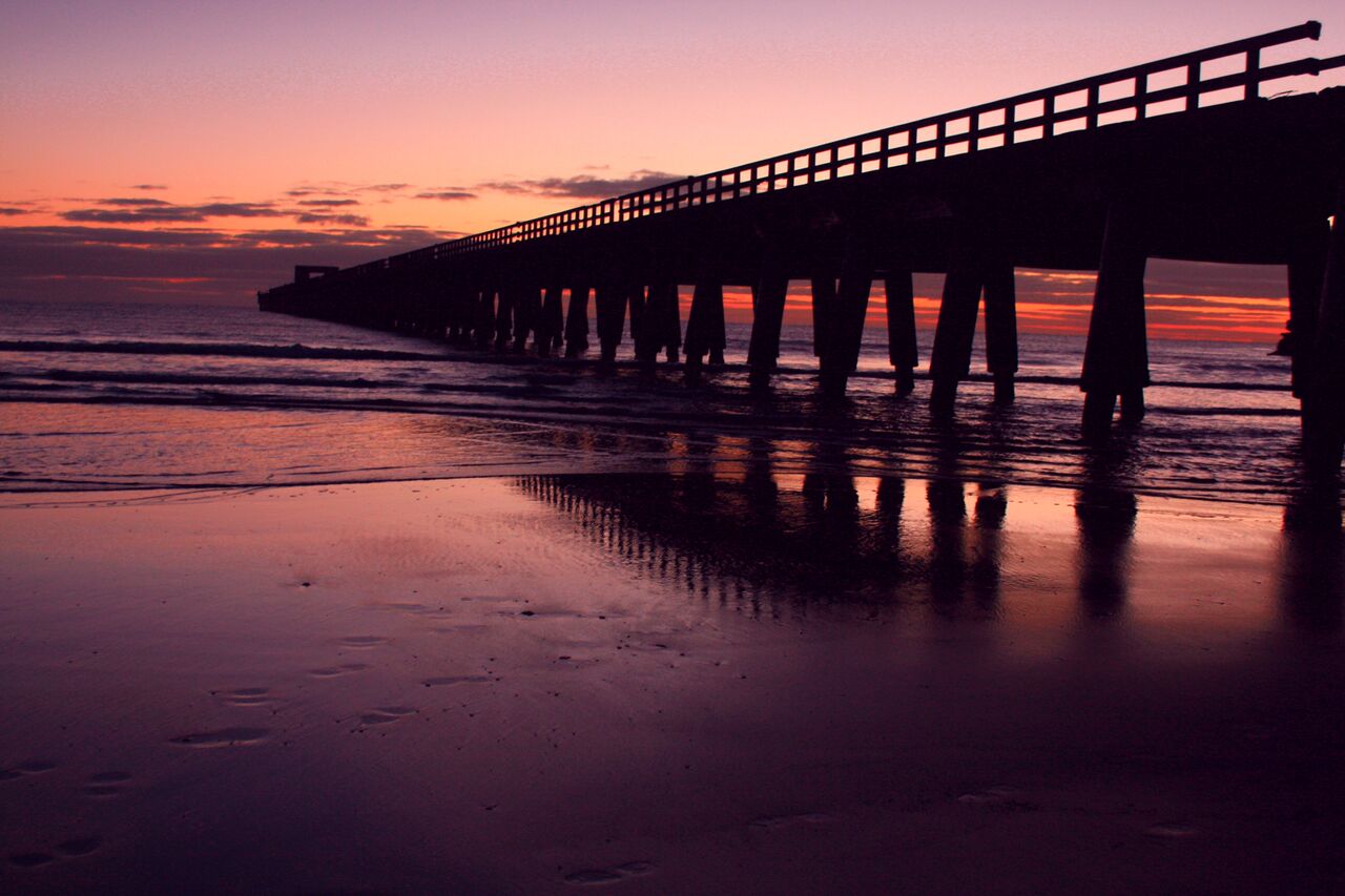

"Tolaga Bay Wharf" — Photo Credit: Vaughan Gillard and Eastland Tourism

Mount Hikurangi Maori Sculpture Experience
Car park to hut: 4 - 5 hr Hut to summit: 2 - 3 hr
Two thirds of the way up Mount Hikurangi, the highest peak in the rugged Raukumara Range, stand nine carved whakairo (sculptures) that tell the story of the demigod, Maui, and his whanau (family). These mighty carved art works celebrate the dawn of the millennium and the infamous Maori legend of Maui, when he fished up the North Island. Mount Hikurangi is said to be the first point to emerge from the sea and is the resting place of Maui’s waka (canoe) Nukutaimemeha. That Maui was one legendary demigod!
The sculptures also stand as a tribute to local iwi, Ngati Porou, as Hikurangi is their sacred mountain. At 1754 metres tall, it’s the highest non-volcanic mountain in the North Island and is the first point to greet the morning sun.
You can see the sculptures by 4x4 drive (guided only) or walk up yourself.
For hikers, watching the sunrise is the goal of climbing Mount Hikurangi. It’s easier to hike up to the hut in the afternoon, stay the night, and then get up two hours before sunrise.
Getting there The track starts 25 km from Ruatoria. Turn off SH 35 onto the gravel Tapuaeroa Valley Road and follow the signs for Pakihiroa Station.
Walk across Pakihiroa Station to Hikurangi summit and yellow markers show the route from the carpark to the hut. Marker poles show the route from the hut up the mountain, although the last 400 m up a scree slope are unmarked - keep left all the way. Extreme care is required.
Know before you go Te Ara ki Hikurangi track crosses private farmland - leave gates as you find them and don't disturb stock.
Visitors are requested to make contact with Te Runanganui o Ngati Porou before embarking on the Te Ara ki Hikurangi track. There is a hut available for public use on the track, book with Te Runanganui o Ngāti Porou.

Arohaki Lagoon Track
3 km return via same track - 4 hr
Arohaki Lagoon is one of the must see sites in the Whirinaki. Impressive tawa/podocarp forest leads to a rain-fed waterway which is home to a number of rare birds. Birdlife includes the blue duck/whio, North Island kākā, red and yellow crowned kākāriki, kiwi and kererū.
The track starts at the Arohaki Lagoon car park, adjacent to River Road, following an old disued hauling track in a westerly direction before descending and crossing the Waiatiu Stream. The track follows a spur and climbs to a terrace before continuing west and reaching a viewing platform at Arohaki Lagoon at the end of the track. The ephemeral lagoon (rain-fed) is surrounded by towering kahikatea and is often alive with frogs, but in times of drought, appears to dry up. Even so, it remains an interesting place to visit.
Getting there: Whirinaki Te Pua-a-Tāne Conservation Park is 90 km south-east of Rotorua. Access to Arohaki Lagoon is via River road, off Old Te Whaiti Road, to the Arohaki Lagoon carpark.
Know before you go: A reasonable level of fitness is required as the terrain ranges from steep uplands to flats.

Lake Kaitawa Fairy Springs Track
Loop Track - 1 Hour
The track leads around the lake past some majestic rimu trees to a turn-off near a small bridge. A left turn here takes you to a translucent green pool in the forest. Water wells up gently as 'Fairy Springs' in this pool. The water flows from Lake Waikaremoana through 'leaks' in the lake bed. Attempts were made from 1948 to 1955 to seal the leaks to maximise the water available for power generation. But water still percolates through gaps in the rock (landslide debris from the Ngamoko Range) to emerge as springs feeding the upper Waikaretaheke River and Fairy Springs.
The track leads around this pool and back to the bridge. Climb over the stile and return to the power station along a gravel road.
Getting there: About 12 km from the Aniwaniwa Visitor Centre towards Wairoa a signpost indicates the turn-off on the left to Kaitawa. Drive down the sealed road to the Kaitawa Power Station. A track on the left of the powerhouse crosses a footbridge over a large stream, the upper part of the Waikaretaheke River, which is diverted here by canal into Lake Kaitawa.

Lake Waikareiti Walk
Two hours return.
Lake Waikareiti is Lake Waikaremoana’s smaller cousin, ‘iti’ meaning little in Maori. The walk is a steady incline on a wide, well-formed track which climbs 300m in height to a day shelter right on the lake edge. It’s a delightful two-hour return hike through a forest of red and silver beech and mighty rimu trees. Even on a rainy day, hikers are sheltered from the elements under the forest canopy.
Hire a boat from the DoC visitor centre and row out to one of the islands on the lake, one of which has its own little lake with an island on it. A more rugged track continues another 3 hours around the lake to Sandy Bay Hut located on an exquisite white sand beach. (Hut fees and bookings apply.)

Tauranga Loop Track
The track starts adjacent to the road and within 5 minutes reaches the historic Tauranga Birdge, spanning the Waioeka River. From the bridge you can see stunning views of the Waioeka River and surrounding native bush.
Once across the bridge the loop track begins and can be walked in either direction.
Travelling clockwise, turn left and walk through regenerating farmland on the southern side of the Tauranga Stream for approximately one hour. The track then crosses over the stream to the northern bank and doubles back along the bush edge to the Waioeka River. There is a second stream-crossing at the mouth of the Tauranga Stream to get back to the Tauranga Bridge.
There are parking and picnicking facilities at the start of the walk.

Haurata Walks
In 2008 Jane Tombleson had a bright idea. Having walked and ridden the hills of their back-country farm for years, she decided it was time to share the outstanding rugged beauty and history of the region with the rest of the world. At the time, her husband Warwick was a little dubious about the merits of such a scheme but nine years later, Haurata Walks are booming. TV crews have filmed there and Haurata is suddenly not the hidden gem it once was.
The landscape is spectacular - steep escarpments and bluffs, bizarre sandstone formations, native bushland, waterfalls, swimming holes, rock slides, native birds, sheep, cattle, wild goats and deer. At night you can even see glow-worms. Consequently there are long and short loop walks of varying degrees of difficulty, each with their own unique features. This is big, steep country so a reasonable level of fitness and sturdy boots are required.
The four to six-hour Top of the World walk takes hikers to the highest point in the region which offers 360-degree panoramic views over Gisborne-Tairawhiti, Mt Hikurangi, Young Nicks Head and Panekiri Bluff.
Te Kooti’s Retreat, a three to five-hour walk, ends at a historic pa site on top of Ngatapa Mountain where, in 1869, the famous Maori Ringatu church leader Te Kooti was surrounded by the English constabulary and Ropata from the Ngati-Porou tribe, before escaping over the cliffs into the Urewera ranges.
Accommodation is available in the Farm House, a four-bedroom holiday home with all the luxuries including an outside tub, or the Backpacker Cottage which offers basic, budget accommodation with all the amenities you need for a great walking holiday. Meals can also be arranged.
- Haurata is approximately 65km from Gisborne city and 24km east of Matawai village.

Eastwoodhill Arboretum
Eastwoodhill Arboretum, 30 minutes’ drive from Gisborne, is the National Arboretum of New Zealand. The 135-hectare site has an outstanding collection of Northern Hemisphere trees, regarded as the largest and most comprehensive south of the equator. Founded in 1910 by the eccentric William Douglas Cook who used to wander around the property stark naked apart from gumboots and a sunhat, it is planted in over 25,000 exotic and native trees, shrubs, climbers and flowers. The many pathways are lovely to walk anytime of the year but the trees are at their most spectacular in autumn when the leaves are on fire with red, gold and amber. Walks cater for all levels of fitness and ability, from flat tree-lined paths to a steep climb up Mt Arateitei with magnificent views of the arboretum and the surrounding countryside. More than 40 species of native and exotic birds come to feast on the seeds, insects and berries within the arboretum.
- The arboretum is 30 minutes’ drive (34.5km) from Gisborne via the Wharekopae Rd.

Oneroa Beachfront Cycle any Walkway
1km, 10-15 minutes
Accessible to all, the Oneroa Cycle and Walkway linking Waikanae Beach to Midway Beach is popular with visitors and locals alike. Since opening in August 2015, there’s been a steady stream of walkers, pushchairs, wheelchairs, trikes, bicycles, skates, scooters and walking frames trundling up and down the 3m wide 1km long beachfront boardwalk and concrete path.
It's a delightful place for a leisurely stroll at any time of the day with a variety of activities and sights to see - surfers and paddle boarders catching perfect waves, children splashing in the sea and building sandcastles, tugs guiding ships into port, competitions at the tennis courts, the cliffs of Young Nick’s Head, white against the blue-green sea, and sunrises and sunsets to take your breath away.
The design of the walkway reflects the region’s seafaring traditions with artistic use of timber patterning, rope lashings and waka-shaped seating areas.
You can extend the walk by starting at Bright Street and following the path along the banks of the Taruheru River which joins the Waimata River to become the Turanganui River. A mere 1200m in length, it’s the shortest river in the Southern Hemisphere.
The foreshore of the Turanganui River resonates with history. It is the landing place of the Horouta canoe or waka, one of the great ocean-going canoes in which Polynesians migrated to Aotearoa-New Zealand about 800 years ago. Commanded by Pawa and guided by the stars, the waka sailed here from Hawaiki bearing the ancestors of the Maori. On board was a tohunga (priest) named Kiwa who was first to step ashore. Hence the Maori name for the region - Turanganui a Kiwa, ‘the standing place of Kiwa’. It is also the place where British explorer Captain James Cook and his crew first stepped ashore in Aotearoa-New Zealand in October, 1769. Cook and a local Maori man saluted each other with a hongi (a nose-to-nose Maori greeting) on Te Toka a Taiau, a rock in the middle of the river – the first greeting between Maori and European. Sadly, the rock was blasted to smithereens in 1877 to make way for harbour development.
- NB. Historians disagree over the official date of Captain Cook’s landing due to the fact that he used ‘ships’ time’ (noon-to-noon). Dates above have been converted to civil time (midnight-to-midnight). If the extra day ‘lost’ in crossing the 180th meridian is added, the first landing was made on 9 October, 1769.

Kaiti Hill Walkway
When visitors come to Gisborne, local residents insist on dragging them up the steep steps to the scenic lookouts on Kaiti Hill, known as ‘Titirangi’ in Maori. They are superb vantage points from which to gain a physical and historical perspective of Gisborne and Poverty Bay before exploring the region. Easily accessed from the harbour, the 15-20 minute climb takes you to several observation platforms with sweeping views over the city, beaches, bay, fertile flats, and ships loading squash and logs at Port Eastland. On a clear day, you can see all the way to Mahia Peninsula and Portland Island to the south.
It’s also the perfect location to view the dramatic headlands that were British explorer Captain James Cook’s first glimpse of Aotearoa-New Zealand nearly 250 years ago. In fact, it was not Cook who first sighted land but Nicholas Young, a cabin boy on the HMS Endeavour. He spotted the white cliffs at the southern end of the bay on October 7, 1769 (*see footnote below) and they were subsequently named Young Nick’s Head (Te Kuri a Pāoa) after him.
Standing at Cook’s Plaza about half way up Titirangi, you can visualise the tall masts of the Endeavour anchored in the bay and Cook coming ashore at a site at the foot of the hill marked by a tall obelisk.
Cook’s encounter with Maori when he stepped ashore for the first time on New Zealand-Aotearoa soil on Oct 9 (*see footnote below) left long-lasting scars. When the ship sailed into the bay, local Maori were mystified by what they saw. They thought the Endeavour was an enormous bird with huge wings and Cook and his men were ‘atua’ or gods. Cook was eager to make friendly contact - however, a series of unfortunate misunderstandings resulted in the tragic deaths of several Maori.
Cook had planned to call the place Endeavour Bay, but instead he named it Poverty Bay ‘because it afforded us not one thing we wanted’. Ironically, Poverty Bay is one of the most fertile areas of New Zealand, famous for its chardonnay wine, and the fruit and vegetables which flourish in the rich, alluvial soils and abundant sunshine. The region has since unofficially adopted the Maori names Tairawhiti, ‘the coast upon which the sun shines across the water’ and Turanganui a Kiwa, the ‘standing place of Kiwa’ after the tohunga (priest) on one of the first voyaging canoes from Polynesia to land here 800 years ago.
There’s a controversial statue of Captain Cook at the plaza which is not an accurate representation of the man or his uniform. Erected in 1969 at the bicentenary of his landing, it’s known as the ‘Crook Cook’. Read all about him on the plaque. Continue to the top of the hill via a track just above and to the right of the statue. At the summit (130m), there’s a World War 2 gun emplacement, an observatory and even more stunning panoramas stretching from Sponge Bay Island (Tuamotu) to Mahia and beyond. Kaiti Hill is also a popular fitness track for local residents.
- NB. Historians disagree over the official date of Captain Cook’s landing due to the fact that he used ‘ships’ time’ (noon-to-noon). Dates above have been converted to civil time (midnight-to-midnight). If the extra day ‘lost’ in crossing the 180th meridian is added, the first landing was made on 9 October, 1769.

Nikau Loop Track
Loop - 20 Minutes
This well-marked, all-weather track is mostly flat with some gentle inclines. It's suitable for families. For a more challenging walk, branch off on the Ridge Track or Mangakawa Track.
Getting there: The track is located in the Morere Springs Scenic Reserve, 40 km east of Wairoa and 58 km south of Gisborne. Access via Morere Hot Springs. The scenic reserve can be accessed via the Morere Hot Springs Pool Complex which opens at 10.00 am and has ample car parking space. The pools complex is managed by a private concessionaire, and fees are payable for visits accessing the reserve via the main entrance from SH2.
Alternative free public access at any time to walking tracks only is via Tunanui Road, approximately 1 km north of the Morere Hot Springs entrance. The track entrance is approximately 500m from SH2. There is no formed carpark at this entrance.

Mangakawa Walkway
The Mangakawa Walkway at Morere Springs Scenic Reserve, roughly 58km from Gisborne, is described by DoC (Department of Conservation) as “among the most diverse and beautiful of New Zealand's short bushwalks”.
This track continues on from the easy, family-friendly 20-minute Nikau Loop Track and becomes a little more physically challenging with stream crossings, boulder hopping and high, steep steps but it’s easily managed in two hours if you have a reasonable level of fitness . . . and sturdy footwear.
There are bonuses on the Mangakawa Track. While your muscles may complain, you are walking alongside the pretty Mangakawa Stream in the dappled shade of a stunning virgin rainforest, a haven for a wide variety of native bird-life. It’s the perfect track on a hot summer day.
And another major plus of the Mangakawa, is that at the end of the hike, you can luxuriate in a refreshingly cool, outdoor pool at Morere Springs where the track begins and ends — or if it's a cold day, soak in one of the hot mineral pools. It's fascinating to see the source of the hot springs as the track takes you right past a pond where the hot water bubbles up and is then piped to the pools below.
The information panels along the way explain how early Maori used nikau palm leaves for thatching, basket-making, floor mats and wrapping food for cooking. They also name many of the other trees that surround you as you walk in the forest.
The scenic reserve, pools and track can be accessed via the Morere Hot Springs pool complex (entrance fees apply). Alternative free public access to the walking track is via Tunanui Road, about 1km north of the Morere Hot Springs entrance. The track entrance is 500m from SH2.
Access during wet weather may be difficult, so please check on track conditions at the Morere Hot Springs office.

Gray's Bush Scenic Reserve Walks
Various Tracks - 15 min - 1 hr
There are two main tracks that loop and link within the reserve. Both are reached from the car park. The 15-20 minute wheelchair-accessible loop track is clearly marked, allowing wheelchair users to immerse themselves in native bush and view interpretation signs along the way. The reserve is on flat land, and is small enough to roam and explore freely. A full circuit of the tracks takes 40-60 minutes at an easy pace.
Getting there: Gray's Bush Scenic Reserve runs alongside Back Ormond Road, about 10 km north-east of Gisborne. The car park and entrance is located on Back Ormond Road, at the turn off to Harper Road. The reserve is signposted from Back Ormond Road.

Te Kuri Farm Walkway
Te Kuri Farm Walkway is a surprisingly challenging farmland walk with multiple ups and downs. It’s a sneaky track that tricks you into thinking you have conquered the last of the steep climbs but then springs another one on you. However, the awesome panorama of Poverty Bay from a lookout point at Town Hill, 290m, makes the considerable effort all worthwhile. On a clear day, hikers can see as far south as Mahia Peninsula and as far west as Maungapohatu on the eastern fringes of Te Urewera National Park.
Remnants of native bush along the way provide a home for tui, kereru (native wood pigeon), ruru (owl), riroriro (grey warbler ) and piwakawaka (fantail). A 2-3 hour, 5.6km loop track that can be walked in either direction, the walkway is on a private farm and is closed each year for the lambing season from 1 August until late October.
Please note, no dogs, horses or mountain bikes allowed. And please leave gates as you find them.

Anaura Bay Walkway
The Anaura Bay Walkway is a two-hour loop track, 60 minute's drive north of Gisborne on SH35, a road that links a series of pristine beaches and also tracks across huge swathes of fertile green farmland.
Beginning and ending at the most beautiful of these remote East Coast beaches, the 4.5km track can be walked in either direction. Park at the DoC camping ground at the northern end of the beach and head steadily uphill on a narrow track through native bush in the company of tuis and fantails.
The track emerges from the bush after about 10 minutes and climbs steeply across grassland to a ridge overlooking Anaura Bay and Motuoroi Island.
The area is rich in history. It's nearly 250 years since Captain James Cook made his second landing on Aotearoa-New Zealand soil in the bay below you.
When HMS Endeavour sailed into Anaura Bay on 22 October 1769 (*see footnote below), the crew were welcomed by Maori in waka (canoes). Cook and his men were given a cordial reception by local chiefs and were able to fill their casks with water from Hawai Stream, where there is a plaque marking the occasion.
Anaura Bay was home to the first comprehensive written description of Maori horticulture and historical records tell us the crew of the HMS Endeavour were astonished by the neatness, regularity and extent of the gardens in the area.
From the ridge, a well-formed track descends on a carpet of soft pine needles through a shady forest to the valley floor. Here hikers cross Waipare Stream which can be muddy and slippery after recent rain. The track then meanders up and down alongside and sometimes in the stream bed, and emerges from the forest in farmland populated with cattle and maize. Cross a stile or two and walk through grassland back to the carpark.
If you’ve got the time, camp overnight within spray-drift of the sea at the Anaura Bay or DoC camping grounds, and walk the length of the sickle-shaped bay, barefoot in the soft white sand and swim in the frothy surf - lukewarm at the end of a long, hot summers day. Take a fishing line with you and dine on kaimoana (seafood) under a canopy of stars. And the next day, you will awake with the sunrise, knowing you are among the first on the planet to see the light of the new day on this most easterly of beaches.

Tolaga Bay Wharf
Before or after the Cook’s Cove walk, a stroll to the end of the historic Tolaga Bay Wharf, the longest in the Southern Hemisphere, is an absolute must.
Built in the 1920s, ships docked at the wharf to deliver supplies and collect meat, wool and livestock from the farms in the district. The last ship called in 1966 after which the structure fell into disrepair.
The wharf is still standing today thanks to the outstanding efforts of fundraisers who could not bear to watch it crumble into the sea. The 660m-long wharf is a stunning sight stretching far into the sparkling blue-green sea against a backdrop of the steep white cliffs.
You will see locals and tourists fishing or jumping off the end of the jetty, hooting with glee as they hit the water. If you are lucky, Verity’s food caravan, the Curbside Café, will be parked on the beach front selling gourmet street food including the world's best burgers.

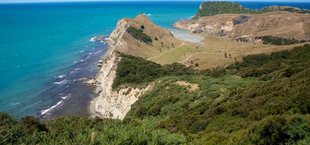
Cook’s Cove Walkway
5.8 km, 2 hr 30 min return.
On the way to or from Anaura Bay, hike the scenic two-and-a-half hour (return) track to another historically-significant location, Cook’s Cove at Tolaga Bay. British explorer Captain James Cook and the crew of the HMS Endeavour came ashore at this sheltered cove, named after the captain himself, and dug a well to collect fresh water.
There was a great deal of friendly contact between the local tribe and the visitors while the ship was anchored in the bay, with Maori taking fish and kumara to the crew by waka (canoe). Joseph Banks, the botanist on board, collected 20 new plant species, some of which the sailors sampled. One of the crew described the landscape as ‘agreeable beyond description’. They were very impressed with the Hole-in-the-Wall (Te Kotere o te Whenua) rock formation, an archway carved by the sea which these days, creates a perfect frame for photographs.
Excellent information panels at the cove explain the history of local iwi, Te Aitanga a Hauiti, and the excavation of an archaeological site once occupied by Maori. Nearby, there’s a New Zealand Historic Places Trust memorial commemorating Cook's visit.
From the carpark, climb steadily uphill across farm paddocks dotted with sheep. Please make sure you stay well away from the cliff edge which is highly unstable. This section of the track is exposed to the sun so set off early in summer and wear a hat, apply sunblock and take water.
Stop on the way up to appreciate the magnificent views of Tolaga Bay and the Uawa River. Just beyond the summit (120m high) there's an excellent viewing platform looking out to the vast expanse of the Pacific Ocean, Cook's Cove and Pourewa Island.
The descent to the cove is down many flights of well-constructed steps in the shade of kanaka trees. It's a flat walk across grassy farmland to the cove, where, depending on the tides, you can walk through the Hole-in-the-Wall and over rocks to the water's edge. Clamber up on the highest boulder for a great selfie and stunning views of the historic Tolaga Bay wharf. If time permits, take a picnic lunch and swimsuit for a dip in the sheltered cove.
Walk across the sandy flats at low tide or around the edge of the cove at high tide to get a closer look at the dramatic Mitre Rocks which jut up steeply from the sea to the left and Pourewa Island to the right.
Explore More Trip Guides
- Trip Guide
Wellington's Best Walks
- 18 Places
- Trip Guide
West Coast Region Walks
- 10 Places
- Trip Guide
Otago's Amazing Day Walks
- 10 Places
- Trip Guide
Southland Region Walks
- 5 Places