

Most people drive up and down the west coast because it's vast and vastly different between small towns. But sometimes it's worth parking the car and venturing down some tracks with some sturdy shoes on. The locals are friendly and the scenery's like nothing you see on the east.
Remember, before embarking on any walk: plan your trip, check the weather, tell someone where you're going and take gear including water, food, warm clothing, jacket, torch, basic first aid kit and a map of where you're walking. To ensure you have an awesome adventure, check out these interactive guides from the NZ Mountain Safety Council.

Pancake Rocks and Blowholes
This is an all weather walk around the famous Pancake Rocks and Blowholes. Looking like giant pancakes the curious limestone formations are especially spectacular at high tide in a westerly sea.
With the exception of an optional short section with steps, the walk is suitable for wheelchairs (with assistance). As the rocks are both fragile and dangerous, it is important to stay on the path.
The blowholes are at their best around high tide when there is a westerly swell.

Heaphy Track
If it’s varied and rugged landscapes with mountain views you’re looking for, you’ll be spoilt for choice on the Heaphy Track. Retrace the steps of early Māori seeking pounamu (greenstone) and 19th century gold prospectors.
You’ll pass through expansive tussock downs, lush forests and nīkau palms before reaching the roaring seas of the West Coast.
Tackle the track in 4 or 5 days, or take your time and soak up the views over 6 days. There is a popular 2-day, overnight return trip on the western side from Kōhaihai to Heaphy Hut. You can also mountain bike the track during the mountain biking season and it is a 2-3 day ride. The Heaphy Track in Kahurangi National Park can be walked in either direction. The track is well marked and signposted, but some sections may be steep and rough and the track could be muddy. This guide describes a 4-day hike for independent, non-guided walkers travelling from Brown Hut to Kōhaihai.

Cape Foulwind Seal Colony & Walkway
A seal colony, a lighthouse and panoramic views of mountains and coastline feature on this spectacular coastal walkway. With the beach close by as well it's a good option for children. It's also one of our best short walks.
Shorter option: Tauranga Bay carpark to seal colony viewpoint Time: 15 min Distance: 500 m
Cape Foulwind short walk takes you from Tauranga Bay along a rocky headland to a viewpoint overlooking a New Zealand fur seal breeding colony.
Panels along the track tell stories of Māori history, sea voyages and early explorers.
Longer option: Seal colony viewpoint to Cape Foulwind lighthouse Time: 1 hr Distance: 2.9 km
From the seal colony, a longer walking track leads to Cape Foulwind lighthouse.
Return the same way or arrange transport from Cape Foulwind car park.

Alpine Nature Walk
This is a 20 minute loop track at the start of the St James Walkway. It leads through an alpine wetland, with views of Gloriana Peak and the Spenser Mountains. Picnic tables make it a great spot to stop while on a longer drive. Getting there The Alpine Nature Walk can be accessed from the St James Carpark 400 m east of the Lewis Pass on SH7 (Lewis Pass Highway).

Bain Bay Track
The track starts at the boat launching site opposite the Lake Brunner Lodge at Mitchells, on the southern end of the lake.
It follows a boardwalk through wetlands and around the lake shore to a secluded camping and picnic area at Bain Bay. Parts of the track also pass through dense forest containing kahikatea, matai and rimu, and tall tree ferns.
Both track and boardwalk can be immersed and impassable when the lake level is high.
About halfway around, a double row of piles in the lake are the remains of an old L-shaped wharf. There are also remains of tramways and other equipment that delivered logs to be towed across the lake to a sawmill at Te Kinga.

Hokitika Gorge Walk
From the car park, follow the walking track for a few minutes through dense podocarp/hardwood forest before emerging onto a viewing platform. From here you can look down to the stunning Hokitika Gorge and out to the lush farmland of Kowhitirangi. This part of the track is accessible for wheelchairs.
From the viewing platform, continue for another 6 minutes along the curving boardwalks and you will reach a swing bridge. From here there are excellent views of the blue-green waters of the Hokitika River as it makes its way through the rock sided Hokitika Gorge.
For good views further up the gorge, cross the swing bridge and when you come to the end of it turn left (straight ahead leads to private farmland). The track continues for another 200 m through the bush to another viewing platform with looking out to the gorge upstream of the bridge.

Callery Gorge Walk
The Callery Gorge Walk begins approximately 5 minutes along the Tatare Tunnels Track with a short, gentle climb to a high terrace behind Franz Josef Waiau township, passing the town water supply pipes and tanks. The track narrows through the rainforest, and follows alongside an old gold mining water race. The water race and some rusty relics are among the last visual reminders of the gold mining era. The track then descends to the historic Callery Gorge bridge. From here there are views of the narrow Callery Gorge which has changed dramatically over the years due to gravel deposits filling in the gorge and raising the level of the riverbed.

Sentinel Rock Walk
This short steady climb up a now bush-covered ice-scraped rock offers the most impressive views of the glacier and the Waiho River. Information panels at the viewpoint show dramatic photos of the glacial retreat, making it one of the best places to appreciate the power of the glacier. Sentinel Rock emerged from beneath the glacier in 1865 and is an example of how the glacial ice ground the hard schist bedrock into a Roche moutonnee or ‘rock sheep’. Since 1909 the glacier has retreated over 3 km and plants have progressively colonised where a veneer of rubble has been dumped over bedrock in the valley.

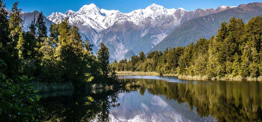
Lake Matheson Walk
Lake Matheson is nestled in ancient forest and is famous for mirror views of Aoraki/Mount Cook and Mount Tasman. Its excellent reflecting properties are due to the dark brown colour of the water – the result of organic matter leached from the humus of the forest floor. Dawn and dusk are the best times to enjoy the reflections in the lake.
Shorter option: Car park to Jetty Viewpoint Time: 40 min return car park to jetty Distance: 1 km return car park to jetty
The first section of the walk, to the Jetty Viewpoint, is suitable for assisted wheelchairs. After crossing the Clearwater suspension bridge, the walk to the Jetty Viewpoint takes you past tall kahikatea and rimu as well as a rich profusion of smaller plant varieties.
The jetty provides a magnificent mountain view reflected in the dark waters.
Longer option: Lake circuit Time: 1 hr 30 min return Distance: 2.6 km return
After walking to the Jetty Viewpoint, continue further around the lake. You will find a similarly magnificent mountain reflection shrouded in native foliage at the View of Views at the top end of the lake, and again at Reflection Island.

Fox Glacier River Walk
Starting from the car park at the end of the Glacier View Road, follow the River Walk Lookout Track as it winds down towards the river.
About 200 m from the car park, the River Walk walking track branches off and continues downhill, passing a great viewpoint of Fox Glacier Te Moeka o Tuawe along the way.
The track then continues through the forest before crossing the Fox River by a 70 m long suspension bridge, built in 1929 at a cost of 1200 pounds.
Getting there
There are two access points to this track. Drive south for 2 km from Fox Glacier Weheka township, and turn left immediately after crossing the Fox River bridge. The Glacier View Road is narrow and unsealed so drive carefully to the car park at the end of this road. The track branches off the fully accessible River Walk Lookout Track.
Alternatively, turn left before the Fox River bridge and park in the small car park on the right about half way up the access road.
Explore More Trip Guides
- Trip Guide
Wellington's Best Walks
- 18 Places
- Trip Guide
Otago's Amazing Day Walks
- 10 Places
- Trip Guide
Southland Region Walks
- 5 Places
- Trip Guide
Central North Island's Best Day Walks
- 6 Places