

Often the best thing about a roadie is pulling over and experiencing something that's sitting right there but you never knew it. There are some walks in the central North Island that only take ten minutes to get to somewhere spectacular. Or there are others that can take you all day like Tongariro but are once in a life time kind of trips.
Remember, before embarking on any walk: plan your trip, check the weather, tell someone where you're going and take gear including water, food, warm clothing, jacket, torch, basic first aid kit and a map of where you're walking. To ensure you have an awesome adventure, check out these interactive guides from the NZ Mountain Safety Council.

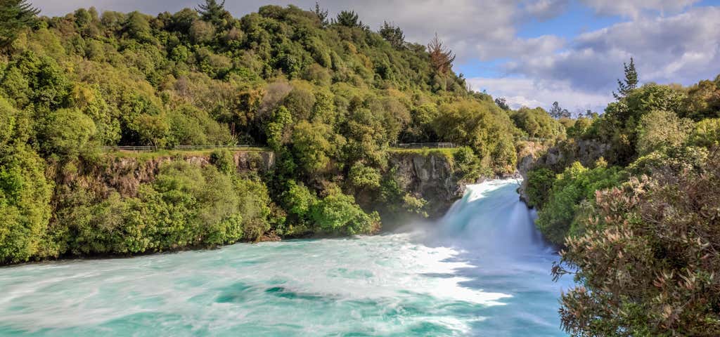
Huka Falls
Time: 10 or 30 minutes
The Huka Falls are the largest falls on the Waikato River, near Taupo on New Zealand's North Island. In fact, they are the most visited natural attraction in New Zealand.
The Waikato river is one of New Zealand's longest rivers and it drains Lake Taupo - the largest freshwater lake in all of Australasia. At Huka Falls, the Waikato River which is normally 100m wide, is squeezed through a 20 metre wide gorge and over a 20m drop. Every second up to 220,000 litres of water gushes through the gorge and shoots out over 8 metres beyond to create a beautful blue/green pool. The name Huka is the Maori word for 'foam', which is appropriate as the falling water and rapids certainly resembles foam, especially under flooding conditions.
Huka Falls is located in Wairakei Park. This is only a short 5 minute drive north of Lake Taupo. Or you can choose the 30 minute riverside walk as a way to get to the several viewing platforms that are available.

Rotopounamu Track
Time: 20 min to the lake to two hours to circle it.
Rotopounamu fills a crater nestled into the western side of Mount Pihanga. It is nine metres deep and covers one square kilometre. The name of the lake comes from the Maori words 'roto' (lake) and 'pounamu' (greenstone).
Beginning opposite the parking area, the track winds gently uphill to the track junction. To walk around the lake, turn right and follow a short section of gravelled track before dropping down towards Five Minute Beach. Here a broad tree stump provides a good spot to view the lake.
Long Beach sweeps along the eastern side of the lake and is an ideal spot for a picnic or rest stop. There is a toilet here.
The track continues to the northern shore where three of the lake's four tributary streams enter the lake. The lake usually has no visible outflow, however when the water levels are low a small outflow can be seen near the shore on the southern side of the lake.
Continuing on, you pass Ten Minute Beach and soon return to the track junction. From here it is downhill to the carpark. Allow two hours for a leisurely walk around the lake.

Tokaanu Thermal Walk
Loop Track - 20 Minutes
This short walk provides an interesting glimpse of a natural thermal area. See steaming hot mineral pools set in sinter basins and spluttering mud pools amidst the native bush. For hundreds of years, Maori have used the geothermal resources of this area for cooking, bathing and leisure. Share in this tradition by having a therapeutic and relaxing swim at the nearby Tokaanu Thermal Pools. Rainbow trout can often be seen here in the cold Tokaanu stream that flows beside the thermal area.
Getting there: The walk begins from Tokaanu Thermal Pools complex (6 km from Turangi on SH 41).
Know before you go: Thermal areas are changeable by nature so please keep to the track and children should be supervised at all times.

Aratiatia Rapids
Time: 10 min Distance: 620 m
The track leading to the two lookout points begins 50 metres from the bridge on the true right of the river. Before the water was diverted to the power station in 1964, the Aratiatia Rapids were the largest in Australasia - the Waikato River dropping 28 metres in just one kilometre. Today their full potential can still be seen during the scheduled daily releases. Each release lasts 15 minutes. Opening times: 10 am; 12 noon; 2 pm (and also 4 pm 1 October - 31 March)
The tiers of the rapids and steep walls of the gorge are remnants of an ancient volcano. It is said the the name "Aratiatia" comes from the meaning "stairway of Tia". Tia was a leader from the waka Te Arawa, and passed through the gorge with a small party on route to discovering Lake Taupo. These are also the famous rapids used in the filming of the barrel escape scene in Peter Jackson's movie, The Hobbit: The Desolation of Smaug.

Spa Park to Huka Falls Walk
Time: 1 hr 30 min Distance: 3 km
This walking track allows you to walk rather than drive to the Huka Falls from Taupo. It's a pleasant walk for the whole family, starting from Spa Park and winding along the banks of the Waikato River.
From the car park walk five minutes down to the river's edge where you'll cross the Otumuheke Stream, a naturally hot stream which flows into the Waikato. The well-defined track then continues along the riverbank and offers lovely views along the way.
Return via the same track or arrange transport from Huka Falls carpark.
For a longer walk, continue from Huka Falls along the Aratiatia Rapids Track. This track is for walkers only, so to mountain bike from Spa Park to Huka Falls take the Rotary Ride.
Getting there: For Spa Park, turn right off Tongariro Street into Spa Road at the northern end of Taupo, then left into County Avenue and drive into Spa Thermal Park.
Helpful hints: Volunteers from the Craters of the Moon Trust have assisted with the management of the Huka Falls since 2000. Visitors are given a warm welcome from local volunteers who run the information kiosk, where you can buy refreshments or use the toilets for 50 cents. But please note that the car park is locked overnight from 6 pm - 8 am in summer (daylight savings), and 5:30 pm - 8 am in winter.

Waitonga Falls Track
Time: 1 hour 20 min Distance: 4 km
Tongariro National Park’s highest waterfall, the 39 metre Waitonga Falls, is reached via a well-formed track through mountain beech and kaikawaka (mountain cedar) forest.
On clear calm days there are fantastic views of Mount Ruapehu and the surrounding countryside. You can see reflections of the mountain in the Rotokawa pools, part of an alpine wetland area.
Banner Photo Credit: GeoZoneUserId_706365
Explore More Trip Guides
- Trip Guide
Wellington's Best Walks
- 18 Places
- Trip Guide
West Coast Region Walks
- 10 Places
- Trip Guide
Otago's Amazing Day Walks
- 10 Places
- Trip Guide
Southland Region Walks
- 5 Places