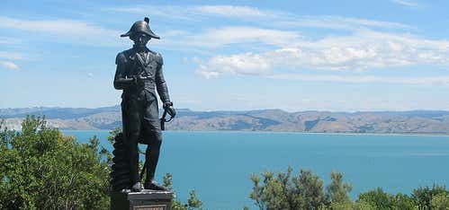
“When visitors come to Gisborne, local residents insist on dragging them up the steep steps to the scenic lookouts on Kaiti Hill, known as ‘Titirangi’ in Maori.”
There are superb vantage points from which to gain a physical and historical perspective of Gisborne and Poverty Bay before exploring the region.
Easily accessed from the harbour, the 15-20 minute climb takes you to several observation platforms with sweeping views over the city, beaches, bay, fertile flats, and ships loading squash and logs at Port Eastland. On a clear day, you can see all the way to Mahia Peninsula and Portland Island to the south.
It’s also the perfect location to view the dramatic headlands that were British explorer Captain James Cook’s first glimpse of Aotearoa-New Zealand nearly 250 years ago. In fact, it was not Cook who first sighted land but Nicholas Young, a cabin boy on the HMS Endeavour. He spotted the white cliffs at the southern end of the bay on October 7, 1769 (*see footnote below) and they were subsequently named Young Nick’s Head (Te Kuri a Pāoa) after him.
Standing at Cook’s Plaza about half way up Titirangi, you can visualise the tall masts of the Endeavour anchored in the bay and Cook coming ashore at a site at the foot of the hill marked by a tall obelisk.
Cook’s encounter with Maori when he stepped ashore for the first time on New Zealand-Aotearoa soil on Oct 9 (*see footnote below) left long-lasting scars. When the ship sailed into the bay, local Maori were mystified by what they saw. They thought the Endeavour was an enormous bird with huge wings and Cook and his men were ‘atua’ or gods. Cook was eager to make friendly contact - however, a series of unfortunate misunderstandings resulted in the tragic deaths of several Maori.
Cook had planned to call the place Endeavour Bay, but instead he named it Poverty Bay ‘because it afforded us not one thing we wanted’.
Ironically, Poverty Bay is one of the most fertile areas of New Zealand, famous for its chardonnay wine, and the fruit and vegetables which flourish in the rich, alluvial soils and abundant sunshine.
The region has since unofficially adopted the Maori names Tairawhiti, ‘the coast upon which the sun shines across the water’ and Turanganui a Kiwa, the ‘standing place of Kiwa’ after the tohunga (priest) on one of the first voyaging canoes from Polynesia to land here 800 years ago.
There’s a controversial statue of Captain Cook at the plaza which is not an accurate representation of the man or his uniform. Erected in 1969 at the bicentenary of his landing, it’s known as the ‘Crook Cook’. Read all about him on the plaque.
Continue to the top of the hill via a track just above and to the right of the statue. At the summit (130m), there’s a World War 2 gun emplacement, an observatory and even more stunning panoramas stretching from Sponge Bay Island (Tuamotu) to Mahia and beyond.
Kaiti Hill is also a popular fitness track for local residents.
* NB. Historians disagree over the official date of Captain Cook’s landing due to the fact that he used ‘ships’ time’ (noon-to-noon). Dates above have been converted to civil time (midnight-to-midnight). If the extra day ‘lost’ in crossing the 180th meridian is added, the first landing was made on 9 October, 1769.
Reviews
Be the first to add a review to the Kaiti Hill Walkway.
/178.028198,-38.680725,14/300x172@2x?access_token=pk.eyJ1Ijoicm9hZHRyaXBwZXJzIiwiYSI6ImNsdjQ5N2VtZDA2bW8ycW13ZHAxeGhjbjkifQ.UIccpoAxc7g3BAuK4s9vjg)
Kaiti Hill Walkway
Hours
- Sun - Sat: 12:00 am - 11:59 pm
Problem with this listing? Let us know.
Has RV parking changed? Let us know.
-
Parking
-
Pets Allowed
-
Restrooms
-
Wifi
-
Wheelchair Accessible
-
Credit Cards Accepted
Parking
Nearby Hotels
Related Trip Guides
New Plymouth to Gisborne Long Weekend Roadie
- 12 Places
- 14:06
- 621 mi
Explore The East Coast On Foot
- 17 Places
Wellington to Gisborne Long Weekend Roadie
- 18 Places
- 19:22
- 826 mi
Cycle The Otago Central Rail Trail
- 34 Places
- 04:20
- 169 mi
