

Remember, before embarking on any walk: plan your trip, check the weather, tell someone where you're going and take gear including water, food, warm clothing, jacket, torch, basic first aid kit and a map of where you're walking. To ensure you have an awesome adventure, check out these interactive guides from the NZ Mountain Safety Council.

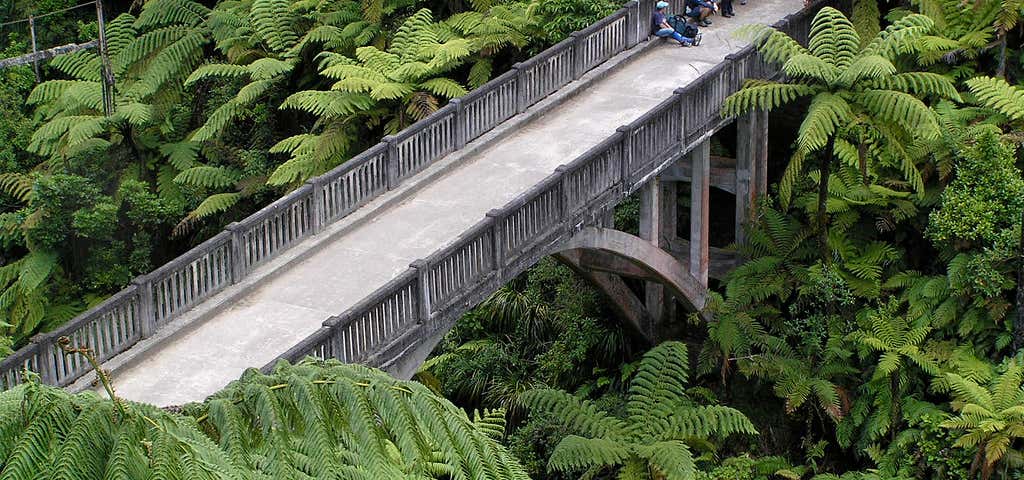
Bridge To Nowhere Track
Walk to an abandoned bridge in the heart of the Whanganui National Park.
The Bridge to Nowhere is a concrete road bridge spanning the Mangapurua Stream in Whanganui National Park, North Island, New Zealand. It has no roads leading to it, but it is a popular tourist attraction, accessible by mountain bike or tramping on a variety of different tracks, or by boat or kayak, followed by a 45-minute (one way) walk along maintained bush trails. It was built across the deep Mangapurua Gorge to provide access to an area where the government was opening up land in 1917 for pioneering farmers, mainly soldiers who had returned from World War I. The intention was to build roads to it later, but the area proved to be so remote and unsuitable for farming that the venture failed and the farms reverted to native bush. A sign on the bridge states: Started in January 1935 and completed in June 1936, this bridge was built by the Raetihi firm of Sandford and Brown, for the Public Works Department. It is 130 feet long, and 125 feet above the stream. The cost of labour was 598 pounds 11 shillings 7 pence, and cartage of all materials (via the Mangapurua Valley road) cost 419 pounds 14 shillings. Unfortunately the cost of materials was not recorded. Aggregate for the concrete is said to have been transported from the Rangitikei River. The completion of the bridge was delayed considerably due to floods, slips, and the consequent delay in the supply of materials. The bridge was built to facilitate vehicular access to the Wanganui River, to link the settlers of the valley with the riverboat service. In 1917 the Government opened up the valley for settlement by soldiers returning from World War I. Virgin forest was cleared, and a total of 35 holdings developed. A school was opened, and for some years the valley prospered. However economic hardship, and problems associated with the remoteness and difficulty of access, resulted in many families abandoning their farms. By 1942 there were only 3 families left. After a major flood in January 1942 the Government declined to make further funds available for road maintenance, and it officially closed the valley in May 1942. The disappearing road line, old fence lines, stands of exotic trees, occasional brick chimneys, and this bridge serve as reminders of the ill fated settlement of the Mangapurua valley.

Waitonga Falls Trailhead
The 39 m Waitonga Falls is Tongariro National Park’s highest waterfall. The well-formed track passes through mountain beech and kaikawaka forest.
Tongariro National Park’s highest waterfall, the 39 metre Waitonga Falls, is reached via a well-formed track through mountain beech and kaikawaka (mountain cedar) forest.
On clear calm days there are fantastic views of Mount Ruapehu and the surrounding countryside. You can see reflections of the mountain in the Rotokawa pools, part of an alpine wetland area.
Getting there
The track begins from the parking area 11 kilometres up the Ohakune Mountain Road.
Nature and conservation
The track is rich in plant life, with mistletoe on the beech trees, and a variety of orchids along the banks. In the alpine wetland area, you can see sundews and bladderworts in addition to the usual larger vegetation of the bog.

Manawatu Gorge
Walk through native bush, enjoy scenic views and experience native wildlife only a short distance from Palmerston North.
You can start the track from the Woodville or Ashhurst end.
Use caution when walking the section of track from Ashhurst carpark, between SH3 and the river. Beware of the sharp drop-off to the river.
From either end the track climbs steadily (and steeply in places) before levelling out for a spell high above the gorge. Five viewpoints along the way give spectacular views of the river, road, railway, reserve and turbines at nearby windfarms.
After climbing up from the Woodville end, the Upper Gorge Bridge track gives an alternative route back down to SH3. This return track takes between 1 hr 30 min to 2 hr. Transport needs to be arranged as this track finishes at a different place to the start.
If you choose to walk for an hour, turn around and come out the same way, it is recommended that you start from the Ashhurst (western) end.
A shorter 4 km loop option is available at the western end of the track.

Atene Skyline Track
6-8 hours loop track.
Beginning at the up-river end, the track climbs steeply from the River Road to a height of 260 m through fine lowland forest. Following an old, gently graded roadline for approximately 3 km the track follows the ridgeline to a clearing which marks the track's halfway point. A campsite with drinking water, a shelter and a toilet is available here.
Shortly beyond this point is the Taumata Trig, the highest point of the track at 572 m. The track then winds around the edge of sandstone bluffs to reach Taupiri Trig before descending steeply back to the River Road.
The focus throughout the walk is Puketapu hill. Many hundreds of years ago the hill stood at the end of a long, narrow-necked peninsula. The river once flowed in an almost complete circle around Puketapu but after years of erosion the river broke through the neck, forcing a more direct route to the sea and cutting off the meander.
Spectacular views from vantage points along the track include the cut-off meander, the Whanganui River, Mt Ruapehu, Mt Taranaki/Egmont, the Tasman Sea, and the Whanganui River's tributary valleys.
Banner Photo Credit: Website
Explore More Trip Guides
- Trip Guide
Wellington's Best Walks
- 18 Places
- Trip Guide
West Coast Region Walks
- 10 Places
- Trip Guide
Otago's Amazing Day Walks
- 10 Places
- Trip Guide
Southland Region Walks
- 5 Places