

On these seven walks around the Nelson & Abel Tasman areas you'll find mighty strolls across pointy Farewell Spit, the ridiculous golden sand in the Abel Tasman, some underwater caves in Takaka and ancient train tunnels in Kawatiri to explore all on foot.
Remember, before embarking on any walk: plan your trip, check the weather, tell someone where you're going and take gear including water, food, warm clothing, jacket, torch, basic first aid kit and a map of where you're walking. To ensure you have an awesome adventure, check out these interactive guides from the NZ Mountain Safety Council.

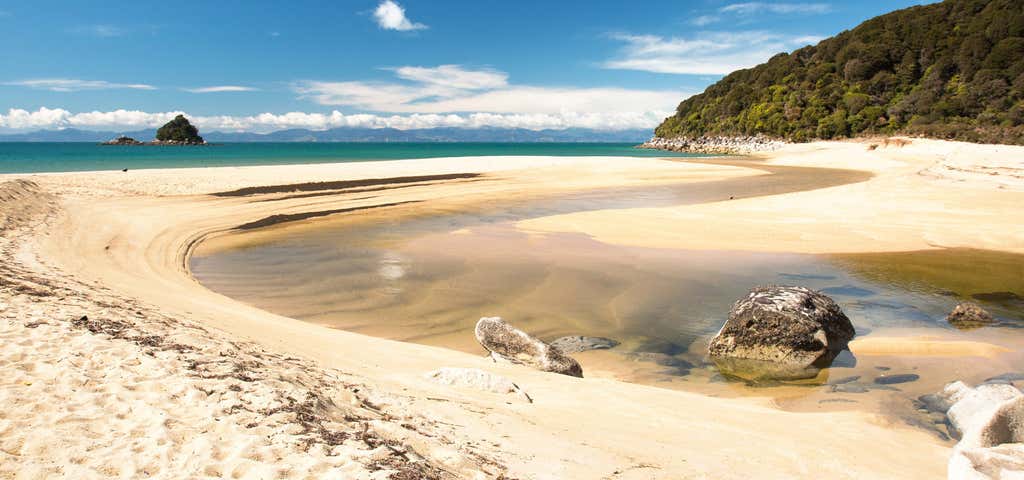
Farewell Spit and Puponga Farm Park tracks
Farewell Spit, at the tip of the South Island, is New Zealand’s longest sand spit (25 km) and a nature reserve. It is an internationally-renowned bird sanctuary with over 90 bird species recorded in the area.
Every spring, thousands of wading birds arrive from the northern hemisphere. Other birds range from black swans to sparrows. Penguins also breed in the area.
The area's attractions include a historic lighthouse, pa sites, the seals and striking landforms of Wharakiki Beach and a cliff top viewing platform.
The caves, islands, and arches of Wharariki Beach, where seals breed, are among the most dramatic in the country. Behind are constantly shifting dunes and a series of lakes and swamps. The vegetation is diverse, with some very rare plants.
The part of the spit that forms the Ramsar Wetland site, covering 11 388 ha, is managed by the Department of Conservation as a Nature Reserve and Shorebird Network Site. The spit is ramsar site number 103, listed on 13 August 1976. This wetland area is both estuarine and freshwater.
History and culture
There is much evidence of Maori occupation in this area. Some is associated with the hunting of moa (now extinct) and harvesting of other foods. Puponga Point, once the site of a pa/fort, is one of many archeological sites.
In 1642, Abel Tasman was the first European to visit the area. In 1770, Captain Cook named it Farewell Spit as he left New Zealand. In 1870, the first lighthouse was built to prevent shipwrecks, which occurred frequently. Grazing of Farewell spit stopped in the late 1930s, but Puponga Farm Park is today a working farm operating under a DOC lease.
Getting there
From Takaka, follow State Highway 60 north to Farewell Spit.

Knuckle Hill Track
This aptly named hill provides the only elevated viewpoint of Whanganui Inlet, a huge estuary declared a marine reserve and wildlife management reserve in 1994.
From the car park, an old logging road climbs gently through regenerating forest to a clearing, where there is plenty of space to relax and picnic. This 5.6 kilometre section of road takes about one hour to walk or a little less to mountain bike. At the clearing, the marked route up Knuckle Hill begins - a short climb of 20 minutes.
If mountainbiking leave your bike at the clearing.
From the top, right on the boundary of Kahurangi National Park, are excellent views of the top of the South Island, particularly Farewell Spit and Whanganui Inlet.

Paynes Ford Tramline Track
The track follows the line of a tramline that operated between the early 1880s and 1905, and was used to take timber from the Takaka Valley down to Waitapu wharf. It provides access to some excellent swimming holes in the Takaka River as well as to rock climbing areas.
Paynes Ford Scenic Reserve takes its name from the original ford across the flood-prone Takaka River on the main road into Takaka. A modern bridge now replaces the ford.
There is a large picnic area with a toilet beside the bridge.

Abel Tasman Coastal Track
Blessed with a mild climate, golden beaches and lush coastal native bush, the Abel Tasman Coast Track has it all.
Visit golden sand beaches, Discover Cleopatra's Pool - natural rock pool with a moss-lined waterslide, Admire the beautiful inlet to Falls River as you walk across a 47 m suspension bridge and Keep an eye out for fur seals/kekeno.
It is well marked and signposted, but some sections may be steep and rough and the track could be muddy.
There is one compulsory tidal crossing - consult a tide timetable before booking your trip.

Riwaka Resurgence
Dancing dappled light, soft moss-covered rocks, babbling crystal-clear fresh water, and native forest alive with bird song all combine to make Riwaka Resurgence a truly magical place. Tread softly and with care when visiting, not only because the marble stairs and rocks can be slippery, but because the resurgence is sacred to the people of Te Atiawa and Ngati Rarua – and it’s not hard to see why.
From Riwaka, head towards Takaka on SH60 and turn left at the signpost just before the start of Takaka Hill. Follow the road for 7km as the scenery morphs from fruit orchards to native bush taking you to a large picnic area alongside the Riwaka River and the start of the short track.
Enter under the impressive carved gateway, called a wahraroa, and enjoy a leisurely stroll to Crystal Pool then up over locally hewn rock stairs to the resurgence pool where pristine water exits the Takaka Hill from an underwater cave after travelling kilometres underground. A metal ladder leads you down to the resurgence pool. Pack your bathing costume in summer and bring some water bottles to fill with some of New Zealand’s best-tasting water.
This is one of the Nelson region’s best-kept secrets and the non-commercial natural experience is hard to beat. It’s an easy 10-minute stroll covering about half-a-kilometre, but the longer you take the deeper the enchantment seeps into your soul; look out for small waterfalls and secretive weka on the way.

Lake Rotoiti Walking Tracks
Bellbird Walk Time: 15 min
This short, wheelchair-standard walk gives an introduction to the Rotoiti Nature Recovery Project area.
This sheltered corner of the lake attracts nectar-feeding birds such as tūī and bellbirds to the large red beech trees that dominate this area. Listen for their enchanting calls as you take this walk. Keep an eye out for other insect-eating forest birds as well. The deciduous New Zealand fuchsia, which is rare in much of the forest due to browsing by possums, may be seen in several places along this walk. The pathway returns through a small wetland area where sedges, rushes, ferns and mosses thrive.
As you walk along the path, you may see traps and/or toxin bait stations – do not touch these as they are important to the work of Rotoiti Nature Recovery Project and may contain poison or cause injury.
The track begins at the car park near the east jetty at Kerr Bay. Allow 5 minutes walking time for this as well as 10 minutes or so to read the information panels along the way.
Black Valley Walk Time: 30 min one way
This walk starts near the Kerr Bay campground and follows the Black Valley Stream through majestic beech forest.
The walk runs parallel to State Highway 63 ad has three entry/exit points along the way that lead off to the Rotoiti Chapel, the village store and Bridge Street.
Brunner Peninsula Nature Walk Time: 1 hr
Beginning at the western side of Kerr Bay below the Visitor Centre, this walk follows the peninsula around into West Bay, twice crossing the Alpine Fault.
Return via Baxter Street or Cotterell Street and View Road.
Panels along the way give an insight into the history of the area.
For a longer walk (1 hr 30 min) continue to the next junction and turn right, returning to Kerr Bay via Rotoiti Lodge and Ward Street. This walk has a good variety of native plants and several easy access points to the lakeshore.
Honeydew Walk Time: 45 min
This walk takes you further into the Rotoiti Nature Recovery Area along a high-standard track.
The Honeydew Walk branches off the Bellbird Walk, which begins at the car park near the east jetty at Kerr Bay.
There are several information panels along this track, which provide information on the recovery project. Allow 35 minutes walking time plus 10 minutes to read the information panels along the way.
The surface is suitable for wheelchairs but would need someone to push on the steeper slopes.
Anglers Walk Time: 1 hr
This walk begins by the Buller River Bridge on Mt Robert Road just below the river's lake source.
The track follows the northern river bank where there are several good spots for trout fishing.
This walk makes a pleasant extension to Moraine Walk and the circuit can be completed by returning along SH63.
Note: A fishing licence is required for fishing rivers and lakes in New Zealand. Eel fishing is prohibited in the lakes and rivers of the national park.
Black Hill Walk Time: 1 hr 30 min return
This walk begins at Rotoiti Lodge and climbs through beech forest and stands of manuka and kanuka to a viewpoint at Black Hill – a solid mound of volcanic rock. Near the top is a clearing from which St Arnaud Village and Big Bush can be viewed.
The track descends steeply to the highway and follows it back to Rotoiti Lodge Road.
This walk can easily be linked to the Brunner Peninsula Nature Walk or Moraine Walk to make a half-day excursion.
Loop Track Time: 1 hr 30 min return
Beginning in the eastern corner of Kerr Bay, the Loop Track takes you well into the Rotoiti Nature Recovery Project area.
Start the track by taking the Bellbird Walk and Honeydew Walk before turning left to follow the St Arnaud Range/Loop Track.
From here, the track climbs a series of terraces to a junction at a creek and then loops back and down until you re-emerge at the lakeshore and join the Lakehead Track, which returns to the car park.
The track is likely to be a bit muddy after rain.
Moraine Walk Time: 1 hr 30 min return
This walk begins at the junction of SH63 and Rotoiti Lodge Road. It winds around the base of Black Hill, over piles of moraine debris left by the ancient Travers Glacier, and past kettle ponds created when blocks of ice surrounded by glacial gravel melted away.
The walk passes through the back of West Bay campground and on to the Buller River.

Kawatiri Historic Railway Walk
The walk starts from a carpark with information panels detailing the rich history of the area. After 200 metres the track crosses an old rail bridge before passing through a train tunnel built in 1923. A torch is helpful but not essential.
The track returns via beech forest above the Hope River closing the loop at the entrance to the tunnel.
Explore More Trip Guides
- Trip Guide
Wellington's Best Walks
- 18 Places
- Trip Guide
West Coast Region Walks
- 10 Places
- Trip Guide
Otago's Amazing Day Walks
- 10 Places
- Trip Guide
Southland Region Walks
- 5 Places