

On these nine walks around The Coromandel you'll find popular strolls to not so popular peaky bluffs, to waterfalls, ancient Kauri trees and beach romps ranging from one to three hours.
Remember, before embarking on any walk: plan your trip, check the weather, tell someone where you're going and take gear including water, food, warm clothing, jacket, torch, basic first aid kit and a map of where you're walking. To ensure you have an awesome adventure, check out these interactive guides from the NZ Mountain Safety Council.

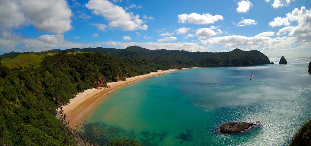
New Chum Beach Track
Cross the stream at the northern end of Whangapoua Beach and follow the rocky foreshore around to the headland.
Here a walking track takes you over the saddle and down into New Chums Beach through nīkau and pōhutukawa. Enjoy a walk along the secluded white sandy beach.
Getting there:
New Chums Beach is immediately north of Whangapoua village.
The beach is accessible by boat or foot.

Cathedral Cove Walk, Hahei, Coromandel
Make your way to the Hahei shops where you’ll find a signpost pointing to Cathedral Cove. Once you’ve followed the sign and parked at Grange Rd – assuming you can get a park as this place can be hectic over summer - ensure you have sensible footwear, water and your swimsuit in the warmer months, then head on down the path. As it’s downhill to the coast, getting there is easier than returning - but it is so worth it.
After about 10 minutes of walking you’ll come to a sign pointing to Gemstone Bay where there’s a very popular snorkel trail, so pack your mask and snorkel too if that’s on the agenda. Or keep walking for 20 minutes and you’ll find the way to Stingray Bay, where you’ll be able to enjoy the clear waters and eponymous stingrays of that small bay. Otherwise keep on going and arrive at Cathedral Cove, arguably one of the most beautiful beaches on the Coromandel Peninsula.
The view of Cathedral Cove through the famous rock arch known as Te Hoho Rock is one of the most photographed spots in New Zealand and because the water around these parts is all marine reserve, visitors are routinely astonished at the vast array of sea life. Always take note of any signs indicating dangers, from rock falls to slips but otherwise, just bring your sunscreen and a big smile. And for those of you who like your beaches a little bit famous, you’ll be interested to learn that Macklemore filmed a music video here and, in the movie version of The Chronicles of Narnia; Prince Caspian, the Pevensie children re-entered Narnia here, using the cave and beach as the portal through which they travelled.

Kauaeranga Valley short walks
You’ll find numerous short walks in the Kauaeranga Valley. Many of the tracks wind through regenerating bush where remnants of the area’s logging history can still be seen.
- Kahikatea Walk - model dam
Time: 20 min/900 m return
A walk leads from the visitor centre through native plantings to the one-third scale replica kauri driving dam. The path crosses the dam as far as the old water race and then you will then need to retrace your steps back to the visitor centre and car park.
- Nature Walk - Hoffman's Pool
Time: 30 min/500 m return
Information panels along this easy walk introduce you to the valley’s native trees and shrubs. Look for the old water supply intake which once fed Thames township and associated stamper batteries. Hoffman's Pool is a great place for a picnic and a summer swim.
- Jasper Creek
Time: 20 min/500 m return
The Jasper Creek Walk starts at Hotoritori campsite and passes through regenerating totara, rimu, towai, kahikatea, with several varieties of fungi and ground orchids. The walk finishes back at the campsite.
- Outlook 76 Time: 1 hr/1.2 km return
Access this walk from the road between Hotoritori and Whangaiterenga Campsites. It involves a climb up to a lookout with excellent views of the valley and Table Mountain. You can return to the road via the same track or descend to Whangaiterenga Campsite, with a 4-minute walk back along the road.to your starting point.
- Edward's Lookout
Time: 1 hr/1.4 km return
Cross the concrete ford beyond Whangaiterenga campsite and walk along a well-formed metal track through manuka-towai forest to a rock outcrop and saddle with extensive views of the valley. This is a favourite spot for abseiling.
- Booms Historical Walk
Time: 30 min/1 km return
Just past the Booms Flat Campsite on the opposite side of the road is a 1920s logging booms site. From here, the walk crosses the river flats and takes you through manuka and kanuka mixed with totara, kauri, five-finger, ground ferns and lancewood before emerging at Catleys Campsite.
- Murray's Walk
Time: 30 min/1 km return
A raised boardwalk takes you through a variety of vegetation from manuka, fivefinger, karamu and koromiko growing at the forest edge, into rewarewa, mahoe, towai, tawa, rimu and rata and past a swampy area with kahikatea and other wetland plants. Nikau and at least three species of tree ferns can be seen along the way.
Getting there: The Kauaeranga Valley is east of Thames on the Coromandel Peninsula.

Waiau Falls and Kauri Grove Lookout Walk
Waiau Falls can be viewed from the roadside 7 km along the 309 Road.
Beautiful native bush surrounds the falls and it is a popular swimming hole in the summer.
Another 1 km up the road, a walking track takes you to the most accessible and mature kauri stand on the Peninsula. This track takes visitors through luxuriant and diverse forest - from Nikau to tree fern to Kauri.

Historic Whitianga Rock
An impressive maori pa once stood on this narrow rocky area in Whitianga Harbour.
Captain Cook visited the site in 1769 and wrote '“A little with[in] the entrance of the river on the East side is a high point or peninsula jutting out into the River on which are the remains of one of their Fortified towns, the Situation is such that the best Engineer in Europe could not have choose’d a better for a small number of men to defend themselves against a greater, it is strong by nature and made more so by Art”.
Several physical features of the pa are still visible. A short track (400m) through pohutukawa bush passes through the ditch and over terraces where houses, cooking shelters, fireplaces and pits for storing crops would have been built. Depressions cut into the rock mark where posts stood. Along the track large areas of midden lay exposed indicating shellfish was an important food source.
At the top of the headland you will be rewarded with spectacular views of Mercury Bay and Whitianga Harbour.
At low tide the remains of a stone structure can be seen at Back Beach. The stone which once formed the high defensive walls on the pa was reused to build a kauri boom which was used to collect logs for transport, this boom dates from the 1880s when kauri logging expanded in the area.

Muriwai Walk
6 km loop - 2 hours
This stunning coastal walk leaves the car park and heads along a benched farm track on the ridge towards Wharekaiatua Pa. Domed topped bollards mark the walk as it is formed and grassed. You will see views across to Great Barrier and the Hauraki Gulf.
Follow along the track until you get to Muriwai estuary (note this is easier to cross at low tide) and continue along the beach until you get to the boat ramp at Port Jackson campsite. Walk through the campsite and head back up Fletcher Bay Road to the Hilltop car park or turn around and return via the Muriwai walk.
Getting there: Head to Port Jackson, 58 km north of Coromandel. From Coromandel take the Colville Road for 22 km until the Whangaahei Junction, then turn left and follow the Port Jackson Road for 28 km until you get to Fantail Bay. From Fantail Bay follow the road for a futher 8 km. Drive along Fletcher Bay Road past Port Jackson campsite and up to the Muriwai Hilltop car park.
Please note, care is required in windy weather as this walk is very exposed.

Fantail Bay Track
1.5 km - 30 min one way
A tramping track leaves from the Fantail Bay campsite and leads to the bushline where you’ll find outstanding views. The pohutukawa grove provides good shade in the summer time. But please note, there is no access across the range.
Getting there: Fantail Bay is approximately 33 km north of Coromandel town.

Matarangi Bluff Track
4.7 km loop - 2 hr 30 min - 3 hr
Nestled in the hills between Matarangi and Kuaotunu on the Coromandel Peninsula, this popular track was conceived by retired local residents in 2010. Built entirely by volunteer labour, residents wanted to provide a recreational area with an educational element for the community. The track is well defined through regenerative natives, pine and wetlands with some stair sections and some narrow crossings (wetlands). It is often jogged by locals in the mornings but it is suited to walkers of all levels with fairly easy gradients and only small steeper sections.
A shorter walk (15-20 mins) is possible up the ridge from the Matarangi side to an elevated cellphone tower with peninsula views and then on to Rings Beach.
Getting there: Access to the track is from the end of Goldfields Drive in Matarangi, or from either end of Rings Beach, with adequate parking handy to all three entrances.
Nature and conservation: The walk has been enhanced with a native tree planting program since 2010 in cooperation with local schools which has seen over 4000 trees established up to 2016. Wilding pines have been eliminated from 37 ha of the wetland area and native trees planted have been selected as suitable species with a view to attracting native birds into the growing forest. This has been supplemented by a trapping program dealing with predators. Trapping of stoats, possums, rats and mice has allowed a remnant population of the endangered fernbird to expand dramatically. The fernbirds populate a 4.5 ha pristine and unmodified wetland in a valley halfway through the track, which has become the focus for planting and trapping, with a loop track following the wetland perimeter.
History and culture: The Matarangi Bluff reserve has been used over the last 170 years for forestry, mining and until 1955 farming by the annual burnoff method. Forest regrowth started after that year but native trees have been slow to establish, birdlife has been under threat especially as wilding pines dominated the landscape.
Please note, the scenic Bluff Road skirting the coast between Matarangi and Kuaotunu has now been closed, due to a dangerous cliff, which has collapsed, and deemed too dangerous to reopen, so Rings Beach is now only accessible from Kuaotunu at the eastern end of Bluff Road.

Square Kauri Tree
The 15th largest kauri on the Coromandel Peninsula. Estimated to be 1,200 years old, this tree has an unusual square-looking trunk. The walking track to the tree is short but steep with 187 steps.
From the viewing area you get good views across to Maumaupaki (Camels Back) on the main Coromandel Range.
Banner Photo Credit: Department Of Conservation
Explore More Trip Guides
- Trip Guide
Wellington's Best Walks
- 18 Places
- Trip Guide
West Coast Region Walks
- 10 Places
- Trip Guide
Otago's Amazing Day Walks
- 10 Places
- Trip Guide
Southland Region Walks
- 5 Places