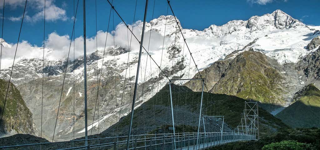
There are few places in the world where you can stroll through such spectacular alpine terrain right to the foot of the country’s highest peak in an hour or so without guides, oxygen and a team of Sherpas or yaks. So take your time in the presence of Aoraki (the Cloud Piercer) as the mountain was named in Maori.
There are a few good walks you can do around the Aoraki village. Remember, before embarking on any walk: plan your trip, check the weather, tell someone where you're going and take gear including water, food, warm clothing, jacket, torch, basic first aid kit and a map of where you're walking. To ensure you have an awesome adventure, check out these interactive guides from the NZ Mountain Safety Council.
Hooker Valley Track
The hike up the Hooker Valley is one of the few flattish walks in the Aoraki-Mt Cook National Park, which by definition, is full of mountains. It’s an easy three-hour, 11km (return) walk from the carpark at White Horse Hill campground. The path is well-formed with a gentle gradient. We recommend wearing hiking boots but we’ve seen Aussies in jandals and the odd tourist wearing high-heeled boots! (please don't do this).
Near the start of the track, make sure you visit the Alpine Memorial, a sobering reminder of the many mountaineers who have perished in the park. Then climb to a viewing point of the magnificent Mueller Glacier and cross the first of three ‘swingy’ swing bridges over the Hooker River.
The track ambles up a wide valley with a profusion of wild flowers and along a boardwalk to protect the delicate eco-system. On a clear day, as you walk up the valley, the views of Aoraki-Mt Cook (3724m) and the glaciers and peaks of the Southern Alps - Ka Tiritiri o te Moana are absolutely jaw-dropping. The track ends at the Hooker Glacier Lake close to the foot of Aoraki-Mt Cook. The lake often has icebergs floating in it - once we spotted a ‘poodle-berg” - so it’s a chilly dip if you decide to take one.
Take lunch with you and spend some time in the presence of the Cloud Piercer.
Then retrace your footsteps and stay a night at White Horse Hill or Glentanner campgrounds, a lodge, or the famous Hermitage Hotel at Aoraki-Mt Cook village so you can watch the splendour of sunset and sunrise over ‘the Cloud Piercer’. Also visit the Sir Edmund Hillary Alpine Centre which showcases the Aoraki-Mount Cook region, its history, people and pioneer extraordinaire, Sir Ed himself.
There are dozens of spectacular walks and climbs to do in the park. Call at the DOC (Department of Conservation) office in Aoraki-Mt Cook village and talk to the highly- knowledgeable rangers there. They will suggest the best walk to suit your ability, time and hiking gear.
Kea Point Walk
Start at the DOC visitor centre and cross over the road to the Hooker valley campground and car park. The walk gently winds its way through subalpine grasslands and scrub to the Mueller Glacier moraine wall, with stunning views of Aoraki/Mount Cook and the Main Divide on good days.
The track passes through a landscape that was formed in 1913 when a stream cut through from the glacier to the original Hermitage site, damaging the building. The walk ends at a viewing deck that gives stunning views of Mount Sefton, The Footstool, Hooker valley, Mueller Glacier lake and Aoraki/Mount Cook.
The track is 2hr (approx.) return from the village and 1hr (approx.) return from the White Horse Hill campground and carpark. In good weather an all-terrain buggy can be pushed along this walk. As this is an exposed walk, so please be careful on windy or wet days.
Glencoe Walk
30 minutes.
Start behind the Hermitage Hotel. The walk zigzags through tōtara trees with a ferny understorey, emerging at a lookout near the prominent water tanks above The Hermitage. A short climb rewards with a bird’s-eye view of the village and beyond to the white ice of Hooker Glacier and Aoraki/Mount Cook. Sunrise and sunset are good times to catch the light-play over the mountains.
Red Tarns Track
2 hours, mainly steep gradient.
Follow the track downhill from the public shelter to cross the bridge over Black Birch Stream and then climb steeply to the Red Tarns. The vegetation changes as you ascend from the valley floor to a superb panoramic viewpoint of the valleys below, the village and Aoraki/Mount Cook. The tarns are named from the red pond weed that grows in them. An aptly placed seat allows you to recover your breath and enjoy the views. This is a magnificent spot to view the sunset in summer.
Bowen Bush Walk
10 min return (loop track) on predominately flat terrain with some steps
This walk starts opposite the petrol pumps. It's an easy forest walk that can be joined with Govenors Bush Walk to form a nature trail. This track wanders through tōtara and celery pine/mountain toatoa forest, and has an alternative exit/entry towards the Mount Cook Backpackers. A ‘Bird Song’ sounds system enhances the experience.
Governors Bush Walk
1 hr return (loop track) over well gravelled track with some steps.
Start this walk at the public shelter. It's a delightful bush walk, which joins with Bowen Bush Walk to form a nature trail and explores one of the few stands of silver beech/tawai (also known as tawhai) forest in the park.
A gradual climb leads to a lookout point of Wakefield Ridge and Aoraki/Mount Cook. This popular walk offers birdlife, a great view of the mountains and a sheltered place to experience the outdoors in poor weather.
Explore More Trip Guides
Wellington's Best Walks
- 18 Places
West Coast Region Walks
- 10 Places
Otago's Amazing Day Walks
- 10 Places
Southland Region Walks
- 5 Places


