

Auckland, like Mexico City and Honolulu is built on a volcanic field which adds an interesting personality to the place with a dash of danger on the side. There are 49 volcanoes in a 20km radius; some are dormant, some are exctinct and some are yet to be discovered. It seems like a rather silly spot to build New Zealand’s fastest growing and largest city but the volcanic activity has provided fertile soils, rocks for building and roads, and aquifiers for water supply. Now the volcanoes simply provide a delicious nature break from the bustling city. The type of volcanic action is called monogenetic which means every eruption occurs in a new location. It’s like the face of a spotty teenager – you never know where a new eruption will appear, you just know one will come up eventually. Mind you it’s been 600 years since the last eruption, creating Rangitoto, so you don’t have to walk around in a boiler suit.

Rangitoto is the youngest and largest volcano forming a near symmetrical cone island in Waitemata Harbour 600 years ago. Apparently the eruption was violently spectacular, spewing forth more lava than any other Auckland eruption. Rangitoto makes a great day trip, starting with an easy 35 minute ferry ride from the bottom on Queen Street or Devonport. The ground is a rich black powder and there are parts that crunch under your feet as if the lava only set yesterday. Seven lava caves are well worth an investigation and the island is home to New Zealand’s largest Pohutukawa forest. It’s a good heart-pumping (one hour) stroll to the top with an extremely satisfying view of the city that will entertain you over lunch (make sure you pack one!). If in summer, take your swimsuit as you can swim in some of the bays and rock pools.
2 hour return.
Height 260 m.
See www.fullers.co.nz for a ferry timetable.

You wouldn’t know Pupuke was a volcano as it’s incognito as a lake. Pupuke (or its full name, Pupukemoana) is an explosion crater – a volcano that blew its head off 150,000 years ago leaving a big hole that filled with water, like Taupo. The fresh water lake is used for many water sports above and below the surface and it’s really nice to stroll around in the middle of suburbia. The path takes you through a mix of reserves and lakes and there is some street walking. The bits by the lake edge – Killarney Park, Henderson Park, Sylvan Park, Kitchener Park and the Quarry Lake Reserve – are the best, but from September to December the path from Henderson Park to Sylvan Park is closed to allow water birds some peace and quiet to nest and breed. To top off this suburban walk you can grab a coffee at the French Rendez-Vous Café at Killarney Park.
90 minutes.
Depth: 57m.
Can get muddy in winter.

One of Auckland’s famous landmarks used to be called One Tree Hill. A grand old totara tree and five pine trees have all graced the top of the dormant volcano over the last four centuries but sadly all have fallen victim to vandalism and protests, with the last tree retiring in 2000. However the name has stuck with many. Maungakiekie would have been a cracker blow when she went sending lava flows for 2.4 km towards the coast at Onehunga, 30,000 years ago - enough lava to fill 32,000 Olympic size swimming pools. The hill once housed three historic Pa (hillfort) site and used by Maori to live in. It’s nestled in Cornwall Park - Auckland’s Hyde or Central Park, which is lush, vast and great to explore by bicycle or foot. The park has plenty of trees to climb or picnic underneath too.
30 mins. Height: 182m. (You can drive to the top)

Maunga-a-Reipae or Mount Wellington is the second youngest volcano, being only 9000 years ago, and the best one to visit if you want less crowds. A deep quarry has scratched the life out of it over years, which means most tourists give it a miss but you do get a different perspective on the city from the top with 360 degree views. And getting to the top is easy. You might find joggers and runners also there, exploring the rim, which you can walk right around. Plus you can peer down into the crater.
25 mins. Height: 135 m.

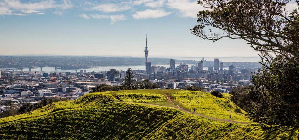
The highest volcano in the region is Mount Eden or Maungawhau, which formed 15,000 years ago. There are usually busloads of curious tourists clicking away at the summit. It’s worth exploring the lower slopes that were also used by Maori up until the 1700s but watch out for cow pats. The best part is the deep, eerie crater at the top. You are no longer allowed to run down to the middle of it and shout your name out, as conservation prevails, but you can feel it’s sleeping power from the majestic rim. When you stand at the top, try and spot the other volcanoes sneaking up through the city and ponder where the next one might emerge.
35 mins. 196m.
Banner Photo Credit: Auckland NZ
Explore More Trip Guides
- Trip Guide
Wellington's Best Walks
- 18 Places
- Trip Guide
West Coast Region Walks
- 10 Places
- Trip Guide
Otago's Amazing Day Walks
- 10 Places
- Trip Guide
Southland Region Walks
- 5 Places