

It would be crazy if the Bay Of Plenty was not full of plenty of stuff to do. And it totally delivers on the walking front. We've included the best hikes - from fifteen minutes to stretch your folded limbs to dusting off the boots and marching somewhere mighty for four hours.
Remember, before embarking on any walk: plan your trip, check the weather, tell someone where you're going and take gear including water, food, warm clothing, jacket, torch, basic first aid kit and a map of where you're walking. To ensure you have an awesome adventure, check out these interactive guides from the NZ Mountain Safety Council.

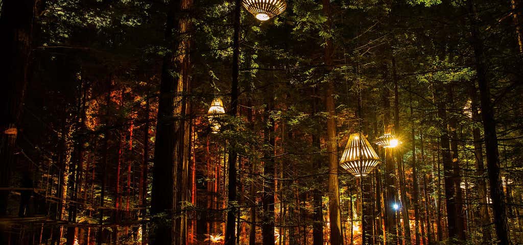
Redwoods Treewalk
Redwoods Treewalk is Rotorua’s newest Eco-Tourism attraction. Using ecologically friendly engineering, the Treewalk is suspended from 110-year-old majestic redwoods. Featuring a series of suspension bridges and living decks, elevated from 6-metres to 12-metres at its’ highest point.
In addition to the day-time treewalk, Redwoods Treewalk and David Trubridge Design have partnered to create an iconic nocturnal tourism experience: the Redwoods Nightlights.
This suspended 30-minute ecological walk, which captures the beauty and ambience of the forest from a bird’s eye perspective Designed for use without harnesses or protective gear, it is suitable for all ages. The only pre-requisite is that all users must be able to walk the entire 553-metres (please don’t carry children – prams and front/back carriers are not permitted).
The Treewalk is 553-meters long. There are 23 bridge sections connected to 22 living decks (platforms).

Karangahake Gorge Historic Walkways
There are several walks at Karangahake Gorge, so you can choose between a choice of loops that take from 45 minutes to 4 hours return.
Connecting the old gold mining towns of Paeroa and Waihi and set snug between the Kaimai and Coromandel Ranges, the Karangahake Gorge is gorgeous, even if you’re only admiring it from your car. But where’s the fun in that, considering this gorge is listed as one of the “14 Wonders of New Zealand”. So do make time to pull over at the Karangahake Domain car park, you’ll know it by the impressive swing bridge that crosses the river. Kitted up with snacks and water, cross the bouncy bridge and follow the signs to the various walkways. You’ll be pleased to know, there are bathrooms at the carpark and over the road there’s a café and a restaurant – but do be careful crossing here as it can get terribly busy during the holiday season.
The Rail Tunnel Loop 2.5km, (allow 90 minutes return) is relatively easy. Sure to impress, this loop follows the Ohinemuri River and passes through pretty native bush with lots of friendly fantails to accompany you on your walk. Two notable manmade marvels are the Crown Battery Site stamper, built in 1892 for crushing quartz, and an 1100metre long tunnel. And because that’s quite a lengthy tube, be sure to have a torch on hand.
Karangahake Gorge Historic Walkway 7km, (allow four hours return), again is a relatively easy walk. Follow alongside the Ohinemuri River, this walk takes in the gold mining relics left over from the days when this peaceful oasis was a bustling mining settlement, with the ruins giving the area an archaeological atmosphere. The walkway includes three bridges, a waterfall and the wonderfully smooth river rocks mean there are plenty of swimming spots. The bush around here can be just the thing for peaceful contemplation, but do keep an ear and an eye out for the cyclists who share the path. Also do try to allow time to take a turnoff to check out the Windows Walk, this track is such a surprise with its secret tunnels and eponymous windows that look out to the river. You’ll find numerous information panels round these parts too, which really help in bringing the history to life. Starting from the Karangahake Reserve car park begin by crossing both the suspension bridge over the Ohinemuri River, and then the Lower Waitawheta Gorge bridge. Go up the stairs and through the abandoned buildings and machinery of the Talisman battery. Then follow the rail track along the gorge and into the old gold mining tunnels. The tunnel has four openings (windows) which look down on the spectacular river gorge far below. The track emerges from the cliff and descends a staircase before crossing the river on a suspension bridge and returning on the opposite side of the gorge along the Crown Tramway Track to the car park.
Alternative route: You can take a recommended side-trip to the remains of the underground Woodstock Pumphouse. After the windows section and the crossing over the Waitawheta River, walk upstream for a short distance (through another tunnel) to where a set of wooden stairs on the right hand side mark the entrance to the pumphouse tunnel. Remains of the beam engine and other machinery can be seen inside, as well as the rafters supporting th ceiling. Glow worms are also visible. A good torch is essential for viewing this unique piece of mining heritage.
Mt Karangahake Summit Walk 4.3km, 4.5 hours return. Moderately challenging, so a decent level of fitness is required. Looming above the western end of this impressive gorge, carved out over the ages, this hike takes some serious effort and you will need to be prepared with food, drink, appropriate clothing and sunscreen because the weather can change quite quickly round these parts. But if you do decide to tackle Mt Karangahake, and you make it to the trig station at the 544m peak, you will feel mighty proud of yourself, even if for a few days afterwards your legs might complain a little on account of the steep sections. With a choice of routes to get you to the top, you’ll pass through native bush, alongside gurgling streams and mossy rocks and, nearer the top of the trail it can get pretty intense and more exposed and in fact in the wetter months it can get pretty boggy too. Starting at the swing bridge at the domain carpark, the only way is up!
Getting there: The Karangahake Gorge is on SH2 between Waihi and Paeroa, at the southern limits of the Coromandel Peninsula. Know before you go: A torch is recommended for the gold mining tunnels, and is essential for viewing the underground pumphouse side trip.

Mount Te Aroha Summit Track
3.9km, 3 hours one-way, good level of fitness required.
Te Aroha is a charming, historic spa town which punches well above its weight for things to see and do. This Waikato wonderland is not only blessed with hot pools, great cafes, and artistic ventures, there’s also a lot of walking to be done.
The obvious walk for the fairly fit would have to be to the top of Mt Te Aroha, the highest point in the Mamaku Ranges. Starting with a fairly stern 1km of relentless ascent, the track begins at Mokena Geyser in the Te Aroha Domain. After walking about 45 minutes, you should arrive at the Wahakapipi Lookout where you’ll want to take a breather and admire the views across the Hauraki Plains, and for some people that will be enough. But if you’re ready to move on, follow the path as it carries on, up up and up for another two hours as it winds its way to the top through beautiful native New Zealand forest. This is a challenging walk and at times the surface is uneven and often steep but, when you reach the top you’ll forget how hard it was because you’ll be distracted by the 360 degree views across the Waikato and Bay of Plenty with clear skies allowing you to see all the way to the mighty mountains of Ruapehu, Ngāuruhoe and Taranaki. Renowned kiwi author Frank Sargeson wrote in his 1973 memoir Once is Enough: “ Te Aroha used to be my favourite climb. From the top I used to see almost the whole of the world I had so far known and felt.” Nicely put.
Then return the way you came or take the slightly longer Tui Mine Loop track option which will add another 30 minutes to the walk and offer new vistas and alternative rocky mountain streams. And do prepare sensibly as this is more than a stroll so you’ll want warm clothes, rain gear, sunscreen, drinking water and food. Lots of food.

Hamurana Springs Track
800 m - 15 min one way
This is an easy, streamside walk through a redwood grove with beautiful views throughout and extensive interpretation along the way. It's suitable for all ages and fitness levels.
You can see the source of the Hamurana Springs’ crystal-clear water from a viewing platform just before you make a choice to either return on the same track or cross the footbridges, walking along the gravel track to the car park to make a circuit. This is a nice, family orientated area with picnic spots in a picturesque setting.
Rawinia Ngati Rangiwewehi looks after the Hamurana Springs Track. You can contact them on +64 7 332 2254.
Getting there: Hamurana is located 15 - 20 minutes drive north-east from Rotorua central, on the left-hand side of Hamurana road.

Rainbow Mountain-Crater Lake Walk
1 km - 15 min one way
From the carpark, follow the signs. There are great views over two crater lakes that are set against a backdrop of bare brown, orange and red steaming cliffs and an array of geothermal vegetation. Fitter and more experienced trampers can continue on the Summit Track to the mountain summit. Add another 3 hours up to the summit and back from the crater lakes.
Getting there: Rainbow Mountain lies 26 km south-east of Rotorua, beside SH 5 (the Rotorua-Taupo highway). Approaching from Rotorua, the carpark for the walking track is situated just past the turnoff for SH 38 (the Murupara/ Waikaremoana highway), on the left-hand side of the road.

Wairere Falls
The falls can be seen from the Te Aroha-Okauia Road and are signposted from the Goodwin Road turnoff. In spring, keep an eye out for the apricot coloured flowers of the taurepo or sandpaper plant on the rocky valley walls.
From the carpark a well formed track weaves its way through moss covered rocks and tree roots. It meets up with the river and there are bridges to assist with river crossings. There is a steady climb up the base of the cliff where sets of steps lead to the top of the gorge. The track passes through a grove of nīkau, pūriri and kohekohe before leading to a lookout platform with a spectacular view looking from the base of the falls. The falls drop 153 m over the steep escarpment, which is part of the Okauia fault line.
The track climbs further with plenty of steps and staircases in the steep section. At the top of the hill the track winds through a rich mosaic of forest species. The track then branches to the falls lookout. From this point the return tramp to the lookout will take you 2 hours, but you will be able to see the magnificent view looking back over the valley and the Waikato Plains.

Blue Lake Track
5.5km, 90 minutes return, easy walking
One of the closest lakes to Rotorua, this one is popular for watersports and swimming, and the loop walk that circles the lake is a lovely way to warm up before submerging yourself in the calm blue waters. The Blue Lake car park, where you’ll find bathrooms, a playground, BBQs – perfect for a picnic - is also the starting point with signs clearly showing the way, with most people setting off to the right. With everything from native bush to stands of impressive trees, quiet sandy beaches and lovely views of both the Blue and Green Lakes (Rotokakahi), this charming walk is popular with locals and visitors alike. There are a few stairs along the track, some rocky surfaces and some boggy patches if there’s been rain and the end of the walk takes you along the road so do take care as sometimes cars seems to come flying round the corners. Of course you can go the other way round, in a clockwise direction, and that way you do the road portion first and end by emerging out of the beautiful bush.

Isthmus Track
1.2 km one way - 20 min.
The track links Lakes Tarawera and Rotomahana and is an integral part of Waimangu 'Round Trip'. Take the launch across Lake Rotomahana and walk across the Isthmus to Lake Tarawera where another launch delivers you to Tarawera Landing. (Contact Waimangu Volcanic Valley, phone +64 7 366 6137.)
Getting there: 26 km south-east of Rotorua. Most visitors access Lake Rotomahana through Waimangu Volcanic Valley (Waimangu Rd, off SH 5). Visitors boating on Lake Tarawera often tie up at Rāpatu Bay and walk to Lake Rotomahana over the Isthmus Track.
Nature and conservation: Lake Rotomahana was internationally famous for its spectacular Pink and White Terraces which were destroyed in the Mount Tarawera eruption of 1886. Steaming cliffs and silica terraces still remain as a feature of this lake. The lake and surrounding margins are a wildlife refuge protecting many species of water fowl. The lake is closed to powerboats in May for the birds' breeding season. Many rare ferns and orchids are found within the thermal areas.
Know before you go: When bathing in geothermal water do not immerse your head, due to risk of contracting the fatal disease Amoebic Meningitis. This disease is caused by water containing the amoeba entering through nasal passages.

Lake Okareka Walkway
2.5km to the outlet, return trip 90 minutes, easy walking.
You can find 18 lakes in Rotorua and Okareka is one of the smaller ones, surrounded by hills and reserve land. Depart from the council’s lakeside reserve on Acacia Rd, 9km from Rotorua, the track takes you through wetlands where a variety of birds live together, including swans, herons, pukeko coots and geese. Along this portion of boardwalk, look out for the hide where budding ornithologists can sit and watch the birds going about their business. As the lake is also popular with watersports enthusiasts, if you visit this spot in winter, you will have a more bird friendly and peaceful experience, although that said, most of the creatures around here are used to a bit of noise from boats. And because there’s a small campground here, there is a toilet block, however you’d still be wise to bring your own drinking water.

Okere Falls Track
1.2 km - 30 min one way.
This is a well-formed bushwalk with scenic lookouts over Okere River and its spectacular waterfalls. There are numerous information panels along the track, describing the human and natural landscape. A wide grassy area beside the main carpark provides a good site for a picnic. And please note, public toilets are provided here as well.
The trout pool is a popular fishing spot, and trout are often seen swimming gently against the current.
From the main lookout platform by Hinemoa's steps you can watch rafters and kayakers sweep over the highest commercially rafted waterfall in the world.

Tarawera Falls Track
700 m return via same track - 20 min one way.
Set off from Kawerau Township, off SH30 between Rotorua and Whakatane. This is the perfect walk if you don’t have all the time in the world to explore around this region by foot.
Starting at the Waterfall Road car park, you’ll head upstream following the course of the Tarawera River. When you reach the bridge, trot over it to continue upstream on the other side of the river where, pretty quickly, you’ll arrive at the falls. If it’s been raining, the path can be a little bit muddy but the falls will be so much more impressive.
The interpretation panels at the falls tell all sorts of interesting stories of the area’s cultural significance while also explaining how it’s thought the falls formed 11,000 years ago when Mt Tarawera first erupted. With a seat up at the falls to sit and admire them, and bathrooms down at the car park, this is a one-stop beauty spot.
But do be aware you need a permit to enter the forest by car, at a cost of $5 per car if bought at the Kawerau Visitor Centre or $6 online at htrg.com

Papamoa Hills Walk
Reasonable fitness, allow 45 minutes to get to the trig station.
Papamoa Hills Regional Park – Te Rae o Papamoa - is a 135ha property rich in cultural heritage with six former Maori Pa sites dotted about the land. The local council has planted over 50,000 trees in recent years so the park features plenty of regenerating bush.. This spot is also a working pine forest and just recently a great deal of forest was cut down which lends a certain barren look in some places, although on the plus side, this means new views exist where you couldn’t previously see out.
Entry to the park is via Poplar Lane off State Highway 2 between Papamoa and Te Puke where you’ll find signage telling you about the various walking trails. The best known and most popular walk takes you straight up to the trig station, 224m above sea level and this is the highest point where you’ll enjoy outstanding views across farmland and out to sea.
Plus there are several other tracks which lead to the various pa sites within the park’s boundary if you want to make a day of it.
Open daily from 6:30am till 7pm in winter and till 9pm in summer, you’ll need plenty of water, sensible shoes and sunscreen with the only toilets found in the car park at Poplar Lane.

Mt Maunganui (Mauao) Summit Walk
Give yourself about 40 minutes to reach the 232m high peak, reasonable fitness required.
Starting point: The Mt Maunganui Surf Club. With several scenic tracks to choose from, no trip to Mt Maunganui in the picturesque Bay of Plenty is complete without a walk up Mt Maunganui.
Two of the most popular tracks to choose from are Oruahine and Waikorire, with both beginning on the ocean side of the base, starting at the boardwalk just beyond the Surf Life Saving Club. All the tracks have quite different flavours, so perhaps if time allows you can try them all over a longer visit.
Mt Maunganui is Maori for ‘big mountain’, and whichever path you choose, the walk up is challenging, but the views when you reach the peak make all that puffing and panting worthwhile. Catch your breath while gazing out upon the entire western Bay of Plenty, south along the white sand beaches of Papamoa and north toward the shores of Waihi and Bowentown and across to the Port and Matakana Island.
Whether you are able to snag one of the picnic tables, or prefer to shelter in the shade of a giant Pohutukawa tree, this walk is fabulous any time of day with sunrise and sunset really blowing people’s socks off.
Local Maori call the mountain Mauao which means ‘caught by the dawn’ and it is indeed very spiritual up here first thing in the morning.
And if you feel like you’ve earned a reward when you get down, why not treat yourself to an ice cream, especially as there are several ice cream emporiums vying for your custom back down at sea level.

Orokawa Bay to Waihi Beach walk
The walk to Orokawa Bay starts at the northern end of Waihi Beach, but please note, it may not be possible to access this track from the beach at times of high tide and strong swell.
The track is popular and skirts the coastal headlands before descending into Orokawa Bay. This beach is not considered safe for swimming due to the steep grade of the seafloor, but is popular for picnicking with its lovely overhanging pohutukawa.
Good fishing can be found off the rocks at the northern end of Orokawa Bay, but do take care for tidal movements and wave conditions which can change suddenly.
Explore More Trip Guides
- Trip Guide
Wellington's Best Walks
- 18 Places
- Trip Guide
West Coast Region Walks
- 10 Places
- Trip Guide
Otago's Amazing Day Walks
- 10 Places
- Trip Guide
Southland Region Walks
- 5 Places