

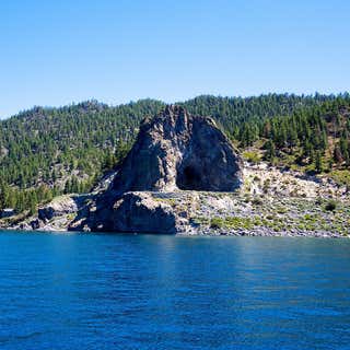
Cave Rock was created over 3 million years ago, and is located on the southeastern shore of Lake Tahoe. You can see the rock structure from almost any point on the lake. It’s still considered sacred to the Washoe Indians and is what they call “The Lady of the Lake” because from the water you can see the profile of a woman’s face in the rock structure, the “Lady”. The hike is very short and only takes about 15 minutes, if that.
There is not much room for parking, but because the hike is so short there is quick turnover. You can just park on the side of the road so it’s free. You’ll start on a dirt path slightly up that parallels Highway 50. You can see the Lake from the path the whole way until you actually reach Cave Rock. You can climb to the top or just hang at the base of the rock.
The views are breathtaking. If you decide to climb up, it is a pretty steep scramble up the rock so be careful.
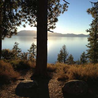
Driving up from Carson City a few times during our stay at S. Lake Tahoe, I noticed a lot of cars were parked on the right side of Highway 50. One day, after playing in the snow, we decided to stop and see what was up. I'm glad we did because the views we saw were absolutely stunning! Amazing views of the lake and the snow covered mountain peaks as its backdrop.
After parking the car, we walked up to a paved walkway. Then, we stopped by the first viewing area where you will see a picture of all the peaks of Lake Tahoe. After taking a lot of pictures, we decided to explore some more and followed the paved path. We passed the bathrooms (closed during our visit), and ended up at another viewing area. Behind this viewing area, we found a hiking trail which led towards the lake. It was another great discovery because from here you can go down towards the lake, climb on top of a big rock, and take more pictures.
The hike in itself was easy for kids
Great photo stop. Excellent view of the lake and coast line. You can also see cave rock. No parking fee, just a pull off north of the cave rock tunnel on the coast road. Limited parking. Very short walk to viewing spots and few stairs. Much easier to get too if you are heading south
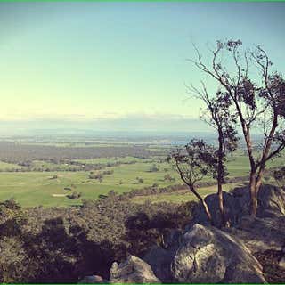
Adresss is closer to 656 Northern Hwy Heathcote turn on to Mt Ida Road keep driving up a dirt road for about 4klm .
Mt Ida lookout is just out of and a 3.5Km drive up a dirt track to the summit. The road is quite good and can be transversed in a two wheel drive vehicle. Once on top there is a great view of Heathcote and the country side below. There are walking track across the ridge through light forest and a small walk to the top of the mountain.
Great place for a walk with a view.
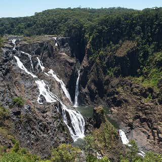
Protected within the Barron Gorge National Park, the volume of water seen in the upper photo only occurs after substantial rainfall during the wet season. For much of the rest of the year, little more than a trickle is evident, due in part to the presence of a weir behind the head of the falls that supplies the Barron Gorge Hydroelectric Power Station located downstream in the gorge.
The Barron Falls may be viewed and accessed by road via the Kennedy Highway that crosses the Barron River upstream of the falls, near Kuranda. The narrow-gauge Kuranda Scenic Railway and the Skyrail aerial tram also leads from the coastal plain to the tablelands. The train stops at Barron Falls overlook, where passengers may disembark for several minutes. The Skyrail stops at two rainforest mid-stations, Red Peak and Barron Falls. The trail at Barron Falls Skyrail station leads through the rainforest to three separate lookouts providing views of the Gorge and Falls.[5]
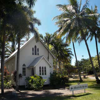
St Mary’s by the Sea is an historic 1880 fully restored non-denominational chapel situated in the heart of Port Douglas. It has a huge glass altar window which offers breathtaking views of the Coral Sea and rainforest clad mountains, stained glass windows, traditional wooden pews and a church bell.
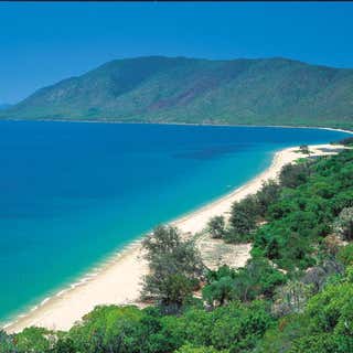
While driving along the glorious coastal road between Cairns and Port Douglas, make sure you stop off at Rex Lookout for a stunning view of Trinity Bay. It’s a great spot to get a group photo with the magnificent blue of the ocean stretching out to the horizon as your backdrop. The lookout is also a popular natural launching pad for hang gliders and becomes a hub of activity on the weekends.
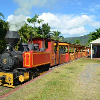
BALLY HOOLEY Does that sound Irish to you? Well, you may well be right, as this was the name given to the end of the line up the Mowbray Valley, more than a hundred years ago, possibly by an Irish immigrant.
Nowadays Bally Hooley is the name given to the historic little steam train that operates from the Marina Mirage station in Port Douglas every Sunday.
It is historic because the two coal-fired steam locomotives (Speedy and Bundy) that haul the trains are both over 55 years old, being the very last ones used by the Mossman Sugar Mill before switching to diesel locomotives for hauling the sugar cane from the fields to the region's mill.
It is also historic because the track on which these trains run has been in existence for over a century, and the whole little set-up is much loved by locals and visitors alike. The railway is operated by a dedicated small group of passionate volunteers. All moneys collected go towards the cost of coal and insurance which are both very big “cash consumers”. Maintenance costs are extremely high also.
The excursion, which takes a bit under one hour for the return trip from the Marina Station, passes through some attractive areas of mangrove, the Sheraton Country Club, and a couple of resorts to the Station at St. Crispins which is adjacent to the 12th tee of the Mirage Golf Course. Located right alongside a tidal lake at St. Crispins, a couple of resident crocodiles can often be seen. At the terminus of St. Crispins Station, the locomotive is turned around on the turntable for the start of the return run to the Marina.
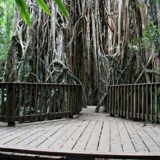
Crater lakes, huge strangler figs, rainforest walks, lakeside camping areas and places of important local history are some of the interesting features along the 28 kilometres Danbulla Road. At least half a day should be set aside to explore the area. Each site is unique, catering for the needs of a wide range of visitors. Choose a secluded camping site at School Point or let the kids kick a football around the grassed area at The Chimneys. Enjoy a short walk through the upland rainforest to Mobo Creek Crater or take time to marvel at the size of the Cathedral fig tree.
Take care when driving. Danbulla Road is narrow, unsealed and has sharp curves and rough surfaces. Be aware of other vehicles, logging trucks, pedestrians and wildlife on the road. The Tablelands Regional Council has erected signs indicating this road is unsuitable for caravans. Lake Tinaroo contains many submerged trees and other hidden hazards. These hazards vary as the water level in the lake changes. Vessel masters must ensure they navigate with extreme caution.
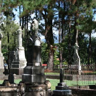
Historical cemetery with interesting pioneers buried here and some sad demises as well. There is occasionally a guided walk complete with period dress, band and actors illustrating various stories. This is an amazing event, well worth booking, guided with lanterns.