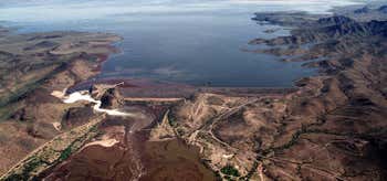
The Dendora Valley is a small valley on the Gila River west of Painted Rock Dam and Reservoir. The valley is north of the river, and is the valley west of the north-south Painted Rock Mountains which form the western end of the Painted Rock Reservoir. The Dendora Valley is only about long. The Gila Bend Mountains form the northern border from east to west, of both Dendora Valley, and the Painted Rock Reservoir adjacent eastwards; this is the famous Gila Bend formed by the Gila River as it changes direction to south, then west entering the reservoir. Other small mountains and hills border the southwest, namely Oatman Mountain, at and the Face Mountain group with Montezuma Head, (peak) to the west. The easiest access route to the Dendora Valley is from Hyder in the Hyder Valley about west-southwest. The coordinates for Oatman Mountain, on the southwest border of Dendora Valley are .
Be the first to add a review to the Dendora Valley.
/-113.08222222222221,33.052499999999995,14/300x172@2x?access_token=pk.eyJ1Ijoicm9hZHRyaXBwZXJzIiwiYSI6ImNsdjQ5N2VtZDA2bW8ycW13ZHAxeGhjbjkifQ.UIccpoAxc7g3BAuK4s9vjg)
Dendora Valley
Hours
Problem with this listing? Let us know.
Has RV parking changed? Let us know.
-
Parking
-
Pets Allowed
-
Restrooms
-
Wifi
-
Wheelchair Accessible
-
Credit Cards Accepted
Nearby Hotels
Related Trip Guides
- Trip Guide
The top things to do on an I-40 road trip
- 35 Places
- 49:44
- 2,851 mi
- Trip Guide
The top things to do on an I-10 road trip
- 55 Places
- 56:13
- 3,026 mi
- Trip Guide
The ultimate guide to Petrified Forest National Park
- 15 Places
- Trip Guide
The ultimate guide to Grand Canyon National Park
- 14 Places