July 2024 - This will be our second attempt to get to Key West. And just like last time, there is a tropical development forming in the Atlantic that may impact our trip. However, it doesn't look as strong and threatening as Hurricane Dorian was. We may very well get away with doing this trip despite Murphy's bad weather plans.

Date:
Pet friendly and free to visit. This is our only stop for the day and just gives us a pretty place to stretch and let the pups go potty.
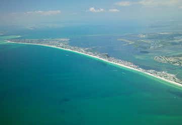
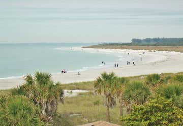
Anna Maria Island, sometimes called Anna Maria Key, is a barrier island on the coast of Manatee County, Florida in the United States. It is bounded on the west by the Gulf of Mexico, on the south by Longboat Pass (which separates it from Longboat Key), on the east by Anna Maria Sound, and on the north by Tampa Bay. Anna Maria Island is approximately seven miles long north to south. Anna Maria Island is at latitude 27.513N, longitude -82.719W. A nautical chart of the island and surrounding waters may be seen at http://www.charts.noaa.gov/OnLineViewer/11425.shtmlHistory. Anna Maria Island was discovered by the local Timucan and Caloosan American Indian tribes and, later, by Spanish explorers in the name of the Spanish Crown. Hernando de Soto and his crew entered the mouth of Tampa Bay, north of Anna Maria Island, in May, 1539, passing it by to make their landfall on the mainland. In 1892, George Emerson Bean became the first permanent resident on the Island, homesteading much of what is now the City of Anna Maria. After Bean's death in 1898, the land's ownership transferred to his son, George Wilhelm Bean, who partnered with Charles Roser, a wealthy real estate developer from St. Petersburg, to form the Anna Maria Beach Company in order to develop the area. The company laid out streets, built sidewalks and houses, and installed a water system.
Our hotel is 4 hours and 15 minutes away.
Date:
We're staying at this hotel both nights. We just need to make sure we only have two dogs out at a time. So you take care of the girls, I'll take care of Jack and we'll enter and leave the room separately so they never see all three pups together since they have a 2 pup limit.
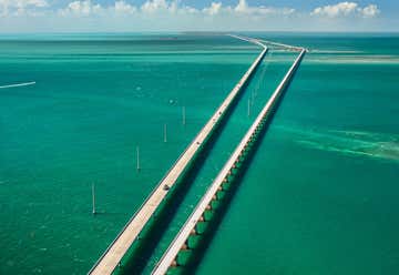
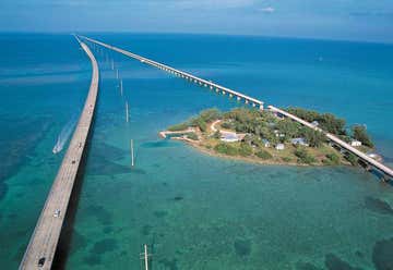
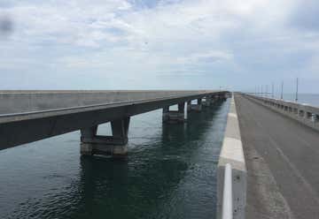
Let's try to leave the hotel by 8 am on Saturday so that we have plenty of daylight to see stuff. Our first stop, 7-mile bridge, is about 2 hours away.
Date:
This isn't really a stop but it's an iconic part of any Key West visit.
A masterpiece of engineering. The Seven Mile Bridge is a famous bridge in the Florida Keys, in Monroe County, Florida, United States. It connects Knight's Key (part of the city of Marathon, Florida) in the Middle Keys to Little Duck Key in the Lower Keys. Among the longest bridges in existence when it was built, it is one of the many bridges on US 1 in the Keys, where the road is called the Overseas Highway. There are two bridges in this location. The older bridge, originally known as the Knights Key-Pigeon Key-Moser Channel-Pacet Channel Bridge, was constructed from 1909-1912 under the direction ofHenry Flagler as part of the Florida East Coast Railway's Key West Extension, also known as the Overseas Railroad. The total length of the new bridge is actually 35,862 ft (10,931 m) or 6.79 miles (10.93 km), and is shorter than the original. Each April the bridge is closed for approximately 2.5 hours on a Saturday and a "fun run," known as the Seven Mile Bridge Run, of 1,500 runners is held commemorating the Florida Keys bridge rebuilding project. The event began in 1982 to commemorate the completion of a federally funded bridge building program that replaced spans that oil tycoon Henry Flagler constructed in the early 1900s to serve as a foundation for his Overseas Railroad. The Seven Mile Bridge was engineered by Figg & Muller Engineers. The structure was completed six months ahead of schedule and has earned eight awards, including an Exceptional Award for Cost Savings Innovation from the Federal Highway Administration. The Bridge has featured in many films such as License To Kill, True Lies, 2 Fast 2 Furious and Mission Impossible III.
Our next stop is about 40 minutes away.

Date:
Perky is a ghost town in Monroe County, Florida. There used to be a Bat Tower here but it was destroyed in a hurricane a few years ago. We may not see anything real interesting here but it would be cool if there are some remnants of the ghost town. Plus it's a good time to stop and let the dogs out to pee.
A HISTORIC SITE IN MONROE County, Florida, the Sugarloaf Key Bat Tower (also known as Perky’s Bat Tower) has been on the U.S. Register of Historic Places since 1982. Built in 1929 by Richter Clyde Perky, a fish lodge owner, the tower was designed to control the Lower Keys’ mosquito problem. The problem: When the bats were put into the tower, they all flew away and never came back.
Built using plans purchased from Dr. Charles Campbell of Texas, a Nobel Peace Prize nominee, the tower was a complete failure. It was supposed to be a deluxe bat house that the animals would continue to come back to so they could feast on the mosquitoes in the area. This tower is only one of fourteen Campbell towers that were built around the world (only three remain standing); the other two are in Texas.
Even though the tower is on the register of historic places, maintenance is rarely, if ever, undertaken. While still in sturdy condition, local teens and vandals often make their tower their own with carvings and litter. But ultimately the tower appears much the same as it did when it was first erected.
Update September 2017: Hurricane Irma destroyed the historic tower.
Know Before You Go Take US-1 South into the Florida Keys. At mile marker 17 take a right hand turn onto Bat Tower Road. Veer to the right at the road fork.
Our next stop is in Key West, half an hour away.
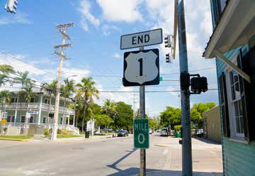
Date:
I wanted to make sure to visit the most iconic spots on our first trip.
The southern terminus of U.S. Route 1. The highway officially ends/begins at the intersection of Whitehead Street and Fleming Street in Key West. It is 2,390 miles from its northern terminus in Fort Kent, Maine... which I also want to visit one day.
LOCATED ON AN OTHERWISE UNASSUMING street corner, this Mile 0 marker garners perhaps just as much love from tourists, bikers, travelers, and highway enthusiasts as its Route 66 counterpart.
U.S. Route 1 stretches from Key West, Florida, more than 2,000 miles to Fort Kent, Maine, not far from the United States-Canada border. The highway connects several major cities along the eastern seaboard such as Boston, Washington, D.C., and Portland, Maine. It’s also commonly referred to as the Overseas Highway in Florida, as it stretches out across the Florida Keys.
Not far from the famous marker is the End of the Road Gift Shop, a small souvenir store dedicated to the green and white sign. Inside, visitors can buy cups and other souvenirs featuring the mile marker sign. Not far from the marker is the Southernmost Point Buoy, which indicates the southernmost point of the continental United States. The buoy also states that from that point it’s just a mere 90 miles to Cuba.
Know Before You Go The gift shop is located at 405 Fleming St.
Our next stop is about 5 minutes away.
Date:
I've always wanted to bring you here since they named it after you. ;-)
Not sure if pets are allowed here or not. But if it's a problem, we'll take turns while one of us sits in the truck with the pups.
Florida State Park and National Historic Landmark centered on a Civil War-era fort in Key West, Florida.
Our next stop is about 10 minutes away.
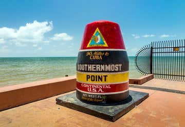
Date:
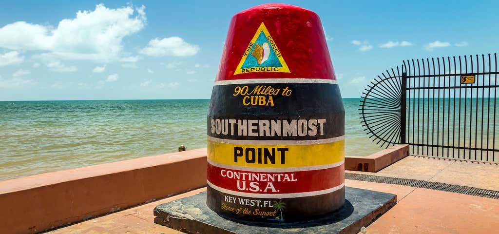
This is another of the iconic spots in Key West. Usually there's an hour-long line unless we get there at sunrise. I'm not interested in waiting in line to get a selfie with it that has no other people in it. If you are, we can.
I'm good with getting pictures close to it and if we time it just right, we can get pics without other people in it. We'll see.
AT THE CONVERGENCE OF WHITEHEAD and South streets on the south coast of Key West, Florida, sits an enormous concrete monument. Made to look like a buoy sticking out of the coral bedrock, this monument just 90 miles from the coast of Cuba marks the southernmost point in the continental United States.
Rather, it claims to mark the southernmost point. The qualifier “continental” before “U.S.A.” is required because Hawaii is actually farther south than Key West. But aside from that, there are technically several islands, part of the Key West National Wildlife Refuge, that are farther south than the monument. And there are even points on the island of Key West proper that lie farther south than this celebrated point.
The Southernmost Point monument, however, offers an easy destination to reach for a photo and a story, even if the claim is technically untrue. The site of the monument has led to the development of several Southernmost-themed hotels, inns, restaurants, bars, and gift shops along South Street, radiating a robust tourist economy that’s a byproduct of making a place that’s fascinating and difficult to reach accessible to everyone.
Know Before You Go Head south on either South Street or Whitehead Street until one meets the other at a corner. The best thing to do is go early in the morning to avoid the cruise ship crowds.You’re close to White Street, so stop there and grab a Cuban coffee to go, then drive over to the point.
Our next stop is just a couple minutes away.
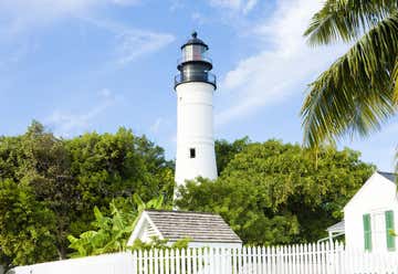
Date:
Pets aren't allowed here, so one of us will wait in the truck while the other goes in.
“haunted historical lighthouse” The Key West lighthouse is located in Key West, Florida. The first Key West lighthouse was a 65-foot (20 m) tower completed in 1825. It had 15 lamps in 15-inch (380 mm) reflectors. The first keeper, Michael Mabrity, died in 1832, and his widow, Barbara, became the lighthouse keeper, serving for 32 years. The Great Havana Hurricane of 1846 destroyed the lighthouse; the USS Morris, which was wrecked during the storm, reported "a white sand beach covers the spot where Key West Lighthouse stood". Barbara Mabrity survived, but fourteen people who had sought refuge in the lighthouse tower died, including seven members of her family. (The same hurricane destroyed the Sand Key Lighthouse, eight miles (13 km) away, killing six people, including the keeper, Rebecca Flaherty, another widow of a previous keeper.) Barbara Mabrity continued to serve as keeper of the Key West Light until the early 1860s, when she was fired at age 82 for making statements against the Union (Key West remained under Union control throughout the Civil War). As both lighthouses serving Key West had been destroyed in the 1846 hurricane, a ship, the Honey, was acquired and outfitted as a lightship to serve as the Sand Key Light until new lighthouses could be built. Due to efforts to reorganize the Lighthouse Board, Congress was slow to appropriate funds for the new lighthouses. The new tower for the Key West Light was completed in 1848. It was 50 feet (15 m) tall with 13 lamps in 21-inch (530 mm) reflectors, and stood on ground about 15 feet (4.6 m) above sea level. In 1858 the light received a third order Fresnel lens. In 1873 the lantern was replaced (it had been damaged by a hurricane in 1866), adding three feet to the height of the tower. The growth of trees and taller buildings in Key West began to obscure the light, and in 1894 the tower was raised twenty feet, placing the light about 100 feet (30 m) above sea level. After the Coast Guard decommissioned the Key West Light in 1969, it was turned over to Monroe County, which in turn leased it to the Key West Arts and Historical Society. The society operates the lighthouse and its associated buildings as the Key West Light House and Keeper's Quarters Museum. On display at the museum is the first order Fresnel lens from the Sombrero Key lighthouse.
Our next stop is an hour away.
Date:
This is just marking the destination point of our trip. At this point, we're turning around and heading home.
Date:
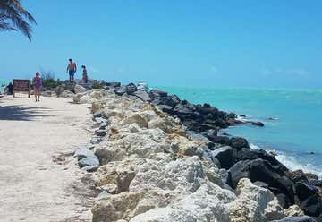
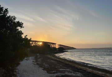
This one is pet friendly.
Although today it acts as an overlook, the old Bahia Honda bridge has had a long and intriguing lifespan deeply connected to the development of the Florida Keys. A small portion of it can be accessed by pedestrians from Bahia Honda State Park.
Our next stop is 40 minutes away.
Date:
Okay, so it's not really a stop, but definitely a part of Florida's history.
The Long Key Bridge, officially known as the Dante B. Fascell Bridge, is a bridge in the Florida Keys connecting Long Key and Conch Key, roughly halfway between Miami and Key West. At a length of nearly two and a half miles, it is the second longest bridge on the Overseas Highway after the Seven Mile Bridge. The current bridge opened in 1982, replacing the parallel Long Key Viaduct, which carried the Overseas Railroad from 1907 to 1935 and was repurposed for highway use shortly after.
Our next stop is half an hour away.
Date:
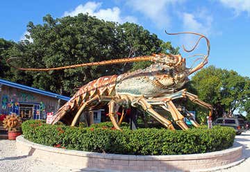
We'll have to take turns here. Probably a good place for souvenirs.
BECAUSE NOTHING IS TOO TERRIFYING to create a giant novelty version of, the Rain Barrel artist’s village in Islamorada, Florida is home to “Betsy,” a massive roadside lobster statue the is a serious contender for the title of the world’s largest lobster.
Modeled in eerily life-like detail, Betsy is a huge spiny lobster that was originally created in the 1980s to celebrate the species which is native to the Florida Keys. Unlike many of its brethren, spiny lobster do not have claws, but as Betsy shows in massive detail, they don’t need them to be alien and frightening. The lobsters’ carapace is covered in sharp spikes and it features a handful of long antennae which are probably not used as whips… but could be.
Betsy’s original home was in the south Florida Keys in front of a different shopping center where she became a popular photo destination rivaled only by the tip soft the Keys themselves. In 2009, the old shopping center wall was converted to a Montessori school and so the monster crustacean was moved to a new location in front of the Rain Barrel Artisans’ Village in Islamorada.
At around 40 feet long and nearly 30 feet tall, Betsy is not just a living nightmare, but may also be the largest lobster in the world despite some vocal opposition from a fiberglass creature in Canada.
“Discover that one-of-a-kind creation” Stroll through our tropical gardens and see the best in contemporary art and american crafts. Discover that one-of-a-kind creation that makes shopping a fun experience. Watch the artists create your masterpiece.
Our next stop is probably about an hour away.
10775 Caribbean Boulevard, Cutler Bay, Florida, United States
Date:
Let's try to check out around 8 am or so. The trip home is always the longest and we want to try to get home at a decent hour because you work tomorrow. But! We do have a few stops along the way.

Date:
THIS SOBERING MEMORIAL HONORS THE memory of the 110 victims of ValuJet Flight 592 that crashed May 11, 1996 in the Everglades. The cause of the crash was determined to be due to expired oxygen generators being improperly carried in the cargo hold. All of the passengers and crew lost their lives during the crash. The memorial was built in 1999 for the third anniversary of the crash.
Memorial does not have good signage, but is on the north side of the Tamiami Canal just to the East of lock L-67. The boat ramp sign is more visible than the sign for the memorial. It is approx 10 mile past the Miccosukee Tribe of Indians of Florida Casino. There is also a Lock/Bridge over canal and a small building with the number S333 where you need to cross canal to get to memorial.
Our next stop is maybe half an hour away.
Date:
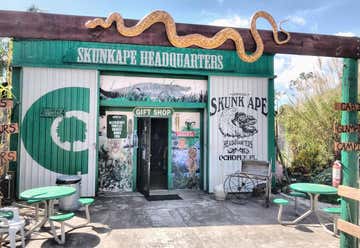
We'll take turns on this one.
“Hunt a famous Florida monster!” Skunk Ape Research Headquarters is open to the public 7 days a week from 9am to 5pm. You can purchase Skunk Ape memorabilia along with blow guns, knives and alligator heads at the Headquarters Store or on line. The Headquarters also features a Reptile & Bird Exhibit of huge gators, constrictors and a variety of exotic birds. Admission is $5 per person, children 5 and under free.
DAVE SHEALY IS THE JANE Goodall of the Florida Everglades. Shealy has spent his entire life studying a smelly hominid cryptid known as the Skunk Ape, and has established the official Skunk Ape Research Headquarters in Ochopee, Florida. Here, Shealy conducts studies, investigates reports on sightings, and brings awareness to the elusive creature of the Everglades.
Shealy is aware that the Skunk Ape – like its alleged distant relative, Big Foot – is considered by many to be a figment of imagination. The United States National Park Service even refers to the creature as nothing more than a “local myth.” Despite the lack of serious attention paid to his cause, Shealy insists that there are 7-9 Skunk Apes currently living in the Everglades, and he has been working tirelessly to document their existence.
The Skunk Ape earns its name for its unusual odor, which some have likened to the smell of rotting garbage, methane or, quite simply, skunks. Some researchers attribute the mammal’s odor to its natural habitat of alligator dens “filled with swamp gas and animal cadavers,” while others maintain that the smell is a result of their lack of bathing. Regardless, all Skunk Ape sightings have made reference to their distinct scent.
According to Shealy, an average male Skunk Ape reportedly stands 6-7 feet tall and weighs roughly 450 lbs. Females are considerably smaller, standing only 5-6 feet tall and weighing only up to 250 lbs. Both sexes are covered in long, reddish or black hair – similar to that of an Orangutan or Gorilla – and stand upright on two legs. Castings made of their footprints have established four toes on each foot. Seasonal stool samples have indicated that their omnivorous diet consists of bird nestlings, wild hogs and native berries.
Though there have been thousands of Big Foot-like sightings over the past few decades, almost all have been reported as spontaneous events. That is to say, most people who go out in search of hominid cryptids often do not find success. Such is not the case for Shealy, who has encountered three Skunk Ape sightings in the course of his field studies.
Since his first sighting at the age of 10, Shealy has been documenting his methods on how to “bait” Skunk Apes. He has compiled these tips into his Everglades Skunk Ape Research Field Guide, which is sold both online and at the Ochopee headquarters. Such tips include instructions on properly “wetting” lima beans (a Skunk Ape’s favorite treat), and a reminder to store deer liver on ice.
Though Shealy has created Skunk Ape baiting tactics, he is vehemently opposed to the poaching or capturing of these mystical creatures. In fact, Shealy recommends that anyone who encounters a Skunk Ape should wait five days before publicizing their findings, so as to give the Skunk Ape sufficient time to leave the area. Additionally, Shealy has been featured on The Daily Show and various TLC and Travel Channel programs, where he has educated people on the Skunk Ape and the fragile ecosystem of the Everglades.
Visitors to the Skunk Ape Research Headquarters can purchase Skunk Ape memorabilia and educational materials (complete with Shealy’s own personal illustrations), as well as experience a reptile exhibition. Overnight stays are available on the campgrounds.
Know Before You Go "We are located at the Trail Lakes Campground on Highway 41 in Ochopee, Florida. We are fifteen miles south of Interstate 75 (old Alligator Alley) then four miles east of Highway 29. We are 36 miles east of Naples, 60 miles west of Miami and just 90 minutes from either the Miami International or Regional Southwest Florida International Airports. "
Our next and final stop is about 2 and a half hours away.

Banner Photo Credit: Shutterstock
