Remove Ads

10 year

  • 20
  • 56:40
  • 3,007 mi
  • $493
Take This Trip

Created by jaswan79 - July 4th 2014

Portland International Airport-Pdx, Northeast Airport Way, Portland, OR, United States

1
97mi 01h 49m
Photo of Oswald West State Park
3.4

Arch Cape OR, Arch Cape, OR, US

Oswald West State Park

1
2
5mi 00h 19m
Photo of Neahkahnie Mountain
4.5

US 101, Manzanita, OR, US

Neahkahnie Mountain

2
3
381mi 06h 37m

Cannon Beach, OR, US

Haystack Rock

3
4
166mi 02h 54m
Photo of Indian Beach
4.3

Cannon Beach Trail, Seaside, OR, US

Indian Beach

4
5
450mi 08h 04m
Photo of Lava Beds National Monument
4.5

1 Indian Wells, Tulelake, CA, US

Lava Beds National Monument

5
6
47mi 01h 30m
Photo of Lassen Volcanic National Park
4.6

44801 State Highway 36 E, Mineral, CA, US

Lassen Volcanic National Park

6
7
209mi 03h 40m
Photo of Ramona Falls
3.6

Forest Road 1825-024, Rhododendron, OR, US

Ramona Falls

7
8
144mi 02h 49m

902 Wasco Street, Hood River, OR, US

Columbia River Gorge National Scenic Area

8
9
176mi 03h 34m
Photo of Proxy Falls
4.5

Oregon Hwy 242, McKenzie Bridge, OR, US

Proxy Falls

9
10
138mi 02h 44m
Photo of Thor's Well - Cape Perpetua
4.4

HWY 101, Yachats, OR, US

Thor's Well - Cape Perpetua

10
11
182mi 03h 33m
Photo of Dee Wright Observatory
4.0

McKenzie Hwy, Blue River, OR, US

Dee Wright Observatory

11
12
11mi 00h 14m
Photo of Crater Lake National Park
4.6

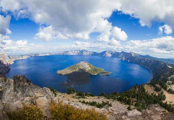
From Medford - Route 62 north and then east. From Klamath Falls - Route 97 north to Route 62 north and then west., OR, US

Crater Lake National Park

12
13
575mi 10h 24m
14
229mi 04h 34m
Photo of Secret Beach & Thunder Rock Cove
3.8
14
15
9mi 00h 17m
Photo of Yosemite National Park
4.6

9039 Village Drive, CA, US

Yosemite National Park

15
16
11mi 00h 27m

47555 Highway 1, CA, US

Julia Pfeiffer Burns State Park

16
17
151mi 02h 50m
Photo of McWay Falls
4.5

Hw 1, Monterey, CA, US

McWay Falls

17
18
4mi 00h 06m
Photo of Sun Portal at Pfeiffer Beach
3.5
18
11mi 00h 15m