Apple Valley, Minnesota, United States
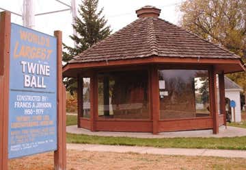
Darwin, Minnesota, is the home of a ball of baler twine rolled by Francis A. Johnson. It is 12 feet in diameter and weighs 17,400 pounds. Johnson began rolling the twine in March 1950, and wrapped four hours every day for 29 years. It is currently housed in a specially made gazebo across from the town park on Main Street, and the town celebrates "Twine Ball Day" on the second Saturday in August every year. An adjacent volunteer-run, free to visit museum and gift shop has information on the history of the ball, as well as selling a variety of souvenirs.

3rd St. between 6th and 8th Avenues, International Falls, MN. Feb 26, 2018 - From International Falls, you can ride the Rainy Lake Bike Trail, which runs 12 miles from International Falls to Voyageurs National Park.
Kabetogama, Minnesota, United States
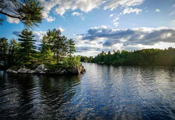
We can take a Grand Voyageur Boat Tour through Border Guide Service for $160 each. This 8 hour trip is a complete tour of the most scenic and historic areas of the park including Lakes Kabetogama and Namakan. In addition to all the highlights of the Ellsworth Rock Garden tour and Kettle Falls tour this trip includes deboarding at Woodenfrog Point and the Ash River Visitor Center, trips into Junction Bay and Daily Brook and the schedule includes time for a meal at Kettle Falls or a picnic lunch on an island or on board. This is a rain or shine trip so please dress accordingly.
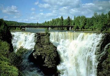
Fort William Historical Park is a leading heritage and cultural attraction that brings people from across North America to our doors to experience northern hospitality, be entertained, and conduct business - just like we did two hundred years ago. This section will allow you to learn more about the Fort’s multi-faceted role and diverse facilities both in the past and in the present.
Grand Portage, Minnesota, United States
Heading south on Hwy 61 toward Cedar Rapids. The state of Minnesota, in 1921, established a trunk highway system. Trunk Highway 1 was one of the longest routes, starting on the border of Iowa and going through Albert Lea, Minneapolis, Duluth, Two Harbors, and Grand Portage before ending at the border with Canada. The portion of Highway 1 along Lake Superior was exceptionally scenic, located on a rocky ledge cut by cascading streams. A travel writer in the 1920s wrote this about the highway: Beyond argument, the drive on this northern shore of Lake Superior between Duluth and Port Arthur [Canada] is a natural classic. This is the land of the sky-blue water and the cathedral red rocks, where the prophetic Indian voice of Gitchie Manitou booms to the joyous loneliness amid the million sea gulls flying like snow. A most satisfying road clings to the shore, now streaming with light, now cut through somber jungle of blue-black trees. The rock-rimmed river gorges were more economically bridged with concrete arch bridges, since the footings could be formed directly from the exposed bedrock.
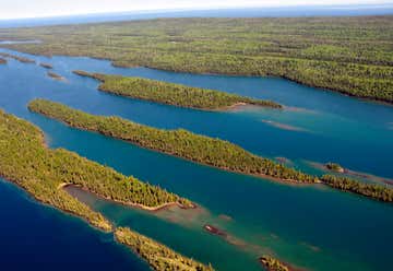
Isle Royale National Park is a U.S. National Park in the state of Michigan. Isle Royale, the largest island in Lake Superior, is over 45 miles (72 km) in length and 9 miles (14 km) wide at its widest point. The park is made up of Isle Royale itself and approximately 400 smaller islands, along with any submerged lands within 4.5 miles (7.24 km) of the surrounding islands. Isle Royale National Park was established on April 3, 1940, was designated as a Wilderness Area in 1976, and was made an International Biosphere Reserve in 1980. It is a relatively small national park at 894 square miles (2,320 km2), with only 209 square miles (540 km2) above water. At the U.S.-Canada boarder, it will meet the borders of the future Canadian Lake Superior National Marine Conservation Area. The park has two developed areas: Windigo, at the southwest end of the island (docking site for the ferries from Minnesota), with a campstore, showers, campsites, and a boat dock; and Rock Harbor on the south side of the northeast end (docking site for the ferries from Michigan), with a campstore, showers, restaurant, lodge, campsites, and a boat dock. The Tobin Harbor Trail at sunsetSleeping accommodations at the park are limited to the lodge at Rock Harbor and 36 designated wilderness campgrounds. Some campgrounds are accessible only by private boat; others in the interior are accessible only by trail or by canoe/kayak on the island lakes. The campsites vary in capacity but typically include a few three-sided wood shelters (the fourth wall is screened) with floors and roofs, and several individual sites suitable for pitching a small tent. Some tent sites with space for groups of up to 10 are available, and are used for overflow if all the individual sites are filled. The only amenities at the campgrounds are pit toilets, picnic tables, and fire-rings at specific areas. Campfires are not permitted at most campgrounds; gas or alcohol camp stoves are recommended. Drinking and cooking water must be drawn from local water sources (Lake Superior and inland lakes) and filtered, treated, or boiled to avoid parasites. Hunting is not permitted, but fishing is, and edible berries (blueberries, thimbleberries) may be picked from the trail. The Greenstone Ridge is a high ridge in the center of the island and carries the longest trail in the park, the Greenstone Ridge Trail, which runs 40 miles (60 km) from one end of the island to the other. This is generally done as a 4 or 5 day hike. A boat shuttle can carry hikers back to their starting port. In total there are 165 miles (265 km) of hiking trails. There are also canoe/kayak routes, many involving portages, along coastal bays and inland lakes.
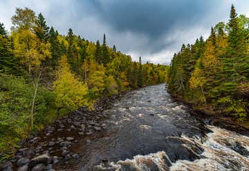
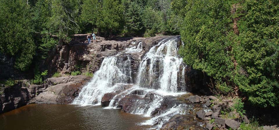
“Explore the Great North!” Come for the quiet, the solitude, and the famous Devil's Kettle waterfall. The most popular hike leads from the trailhead upstream along the Brule River to Devil's Kettle, where the river splits around a mass of volcanic rock. Half of the river plunges 50 feet into a pool, while the rest pours into a huge pothole. Anglers can catch brook and rainbow trout in the Brule River or its tributary, Gauthier Creek. The park offers camping, picnicking and hiking. Moose, white-tailed deer, black bears, and timber wolves are among the larger animals that inhabit the park. Smaller mammals that visitors may see include the woodchuck, snowshoe hare, red squirrel, and chipmunk. In the spring and summer, listen for the songs of warblers. All year round, chickadees, nuthatches, jays, woodpeckers, and ruffed grouse can be seen in the park. Concrete foundations in the campground and picnic areas of the park are remnants of a transient work camp built there in 1934 by the State. The camp provided work and lodging for men displaced during the Depression years. In addition to building trails, logging, and completing public service projects, these men helped fight a fire in 1935 that burned more than 10,000 acres in the area. Later the men set up a sawmill and began to salvage fire-damaged wood. In 1957, a 940-acre parcel of forest along the Brule River was set aside as Brule River State Park. The park became Judge C. R. Magney State Park in 1963 when the Minnesota legislature selected this park as a memorial to the late Judge Magney, a lawyer, mayor of Duluth, justice of the Minnesota Supreme Court, and a strong advocate of Minnesota State Parks, especially those along the North Shore. With his influence, he was instrumental in establishing 11 state parks and waysides along Lake Superior. Over the years, parcels of land have been added to the park which today totals 4,642 acres.
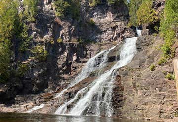

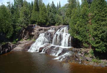
Gooseberry Falls State Park is a state park of Minnesota, USA, on the North Shore of Lake Superior. The park is located in Silver Creek Township, about 13 miles (21 km) northeast of Two Harbors, Minnesota in Lake County on scenic Minnesota Highway 61. The Joseph N. Alexander visitor center, built in 1996, provides space for interpretive displays, a cinema screening room, and a gift shop.The park provides 70 non-electric camping sites that are available year-round. There are 18 miles (29 km) of hiking trails, including 8 miles (13 km) of mountain bike trails. The trails connect to the Superior Hiking Trail.The rustic style resources in Gooseberry Falls State Park were constructed by the Civilian Conservation Corps between 1934 and 1941. The structures are notable for their stone construction, using red, blue, brown, and black granite. The designs were supervised by the Minnesota Central Design Office of the National Park Service and construction was supervised by two Italian stonemasons.
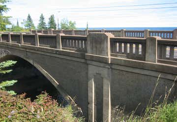
Bridge No. 3589 in Silver Creek Township, Minnesota is a reinforced concrete arch bridge carrying Minnesota State Highway 61 over the Stewart River just north of Two Harbors, Minnesota. The bridge was built in 1924, originally with a span and a width of . It was widened to in 1939 because of increasing traffic loads. The bridge was listed on the National Register of Historic Places in 1998.
The bridge is notable for its Classical Revival detailing. Usually, the Minnesota Highway Department devoted more detailing to urban bridges than rural bridges, but the scenic location on a popular tourist route lent itself to a more architecturally-detailed approach. As a result, the bridge was designed with open-balustrade railings, an emphatic archivolt, and monumental pilasters with recessed panels accented by contrasting concrete finishes. The original bridge was finished in 1924. By 1934, so many travelers were using the highway that the highway department proposed widening the bridge. Funds were not available until 1939, at which point the bridge was widened. The cost of widening the bridge was $12,793, and the widening respected the bridge's original design.

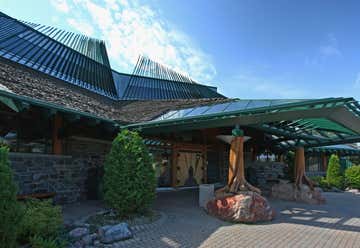
Built in 1908 for the Congdon family. Standard one-hour guided tour includes the basement, first floor, and second floor. The 1.5-guided hour tour also includes the third floor. The carriage house and the landscaped grounds can be explored unguided. The Full Mansion Tour is the best tour to get a complete mansion experience, as it includes the self-guided General Admission floors and a guided tour of the Third Floor & Attic.
The Third Floor shows off the Congdon Boys’ rooms and even a few rooms that have recently been restored back to their original glory. The attic shows the bones of the home such as the steel and concrete that make up the home. Plus in the attic are many unique items such as the original rugs to rare furniture.
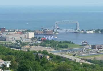
Built in 1939, Enger Tower, a 5 story structure constructed of national Blue Stone taken from this region, stands guard from the top of the Duluth skyline. Looking out over the Duluth Harbor and the St. Louis Bay, the green beacon mounted at the very top of the western Duluth hillside brings it to 531' above the level of Lake Superior. The tower was dedicated by Crown Prince Olav and Crown Princess Martha of Norway on June 15, 1939. The dedication was in honor of Bert Enger, a native of Norway who came to this country and became a successful furniture dealer. At the time of his death Mr. Enger donated two thirds of his estate to the city of Duluth. This included the land known as Enger Hill which includes Enger Tower, the park and Enger Golf Course. There are numerous lookouts at each level of the octagonal tower, with a stair case taking you all the way to the top. Each level offers fantastic photographic opportunities from every vantage point.
Banner Photo Credit: Pixabay
