

Grant, Colorado, United States
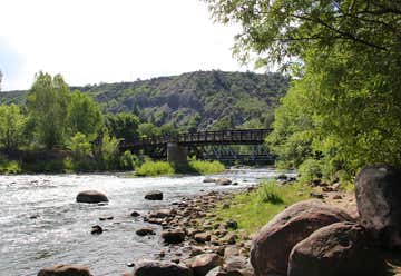
At Grant, make a right onto Guanella Pass Road which runs along Geneva Creek. Go about a mile to a turnout on the right
Fairplay, Colorado, United States

REACH HERE BY 3:00 and spend an hour
We have several large African Sulcata tortoises that wander freely throughout the their own sections of the tour. Feel free to pet these tortoises, but watch your step, there are several low “tortoise fences” too keep each tortoise in his or her section. Two of our most popular exhibits are the albino alligators, including Mr. Bo Mangles, and Morris the Hollywood alligator from “Happy Gilmore”. Some of the other reptiles you can see at Colorado Gators Reptile Park are: fearsome Nile crocodiles, Burmese pythons, a 17′ reticulated python, anacondas, red tail boas, 3 species of rattlesnakes, monitor lizards, tegus, geckos, iguanas, box turtles, snapping turtles, and caiman. The tour also includes our working fish farm.

REACH HERE BY 1:30 and spend an hour
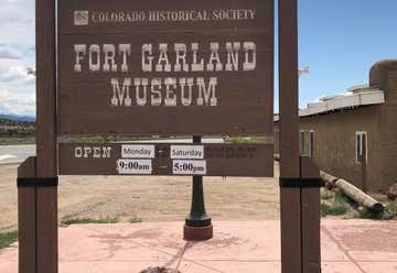
Fort Garland was once commanded by legendary frontiersman Kit Carson and had a garrison of over 100 men who served to protect the earliest settlers in the San Luis Valley. Tour original adobe buildings on the grounds and view excellent exhibits on how the fort was saved and preserved. And, don’t miss the Infantry and cavalry barracks exhibits, an exhibit on the Buffalo Soldiers and the historic dioramas.
Alamosa, Colorado, United States
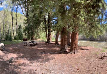
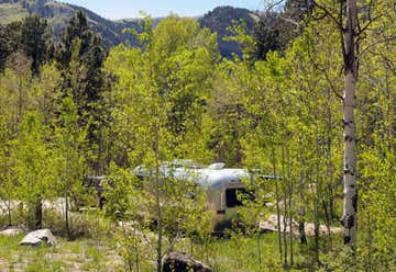
Just past Southfork, this small campground, stretches along the banks of the South Fork of the Rio Grande River among mature spruce. Many sites are adjacent to the river. US Highway 160 is very close by so some traffic noise is common day and night. With heavy understory, the campground has the feel of spacious seclusion and is very cool and shady. This is bear country; practice safe food storage techniques. There is fishing nearby in the South Fork of the Rio Grande and Park Creek. Wolf Creek Pass is 9.5 miles west from the campground. The facilities include 13 newly remodeled gravel sites with tables and steel fireplace rings (firewood is not provided), 2 vault type toilets, a centralized refuse bin and a developed drinking water system with hand pumps (in season) and adequate turn around and parking space for trailers. This is a great nightly stop over campground for travelers on US Highway 160.
REACH HERE BY 5:00. $20 fee. This is all National Forest so if there is no room, find a place
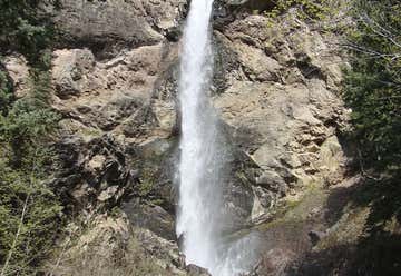
After wolf Creek ski resort and hairpin turn, look for Treasure Falls overlook. For the night, Ute Campground four miles north after Chimney Rock, Hwy 151. Treasure Falls is a 105 foot, plunge waterfall just 15 miles outside of Pagosa Springs, Colorado. It’s just a 1/2 mile hike in to the falls where you can get close enough to feel the spray and mist from the falling water. It’s a sight that kids and adults alike will remember. Explore the full Treasure Falls hike profile below for trail map, driving directions, and more of the details you need to enjoy this adventure near Wolf Creek Pass in Colorado.
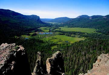
Wolf Creek Pass (el. 10,857 ft.) is a high mountain pass on the Continental Divide, in the San Juan Mountains of Colorado. It is the route through which U.S. Highway 160 passes from the San Luis Valley into southwest Colorado on its way to New Mexico and Arizona. The pass is notable as inspiration of a C. W. McCall song. The pass is significantly steep on either side (7 to 8% in most places) and can be dangerous in winter. There is a runaway truck ramp on the westbound side for truckers that lose control of their brakes. Wolf Creek Pass was made famous in 1975 by Country music artist C. W. McCall's humorous spoken word song of the same name, in which the pass is fondly described as "37 miles o' hell -- which is up on the Great Divide." In the song, two truckers drive an out-of-control 1948 Peterbilt down U.S. Highway 160 to Pagosa Springs -- a 5,000-foot (1,500 m) drop in elevation.
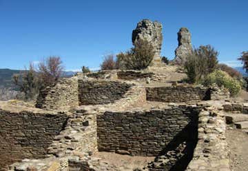
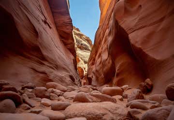
This undiscovered gem is an intimate, off-the-beaten-path archaeological site located at the southern edge of the San Juan Mountains in Southwestern Colorado. You’ll walk in the footsteps of the fascinating and enigmatic Ancestral Puebloans of the Chaco Canyon, following primitive pathways that haven’t changed for 1,000 years. Archaeological ruins and artifacts, abundant wildlife, and its setting in the breathtaking San Juan National Forest make Chimney Rock a must-see.
Chimney Rock covers seven square miles and preserves 200 ancient homes and ceremonial buildings, some of which have been excavated for viewing and exploration: a Great Kiva, a Pit House, a Multi-Family Dwelling, and a Chacoan-style Great House Pueblo. Chimney Rock is the highest in elevation of all the Chacoan sites, at about 7,000 feet above sea level. From the base, the hike to the top is just a half mile and it’s rewarded with dramatic 360-degree views of Colorado and New Mexico.
This trail, also known as ART, is the backbone of the city. It would be a nice place to eat lunch and rest from the drive. It connects to the library and parks, so you should find a place to park and have easy access to the trail.

Where Hwy 550 crosses the railroad tracks, turn right into a turnabout. BE SURE TO CHANGE TO PACIFIC TIME. You will need to leave by 6:00am