Hogback Interpretive Site sits along the Bighorn Scenic Byway. Hogback About 500 million years ago the air and land were warmer, and the seas covered all of Wyoming including the area you see. You would not recognize any animal life at that time. None of it lived on land. Then around 75 million years ago, the earth’s crust began to grind together. The earth buckled, heaved, and the Bighorn Mountains formed. The long sharp red ridges in front of you are called “Hogbacks.” Other geological formations to look for are steep escarpments, sheer almost vertical sides caused by the fault that runs along this ides of the Bighorn Mountains, synclines, downfolds in the earth’s crust that cause valleys, and Cuestas, long gentle upslopes of alternating hard and soft rocks.

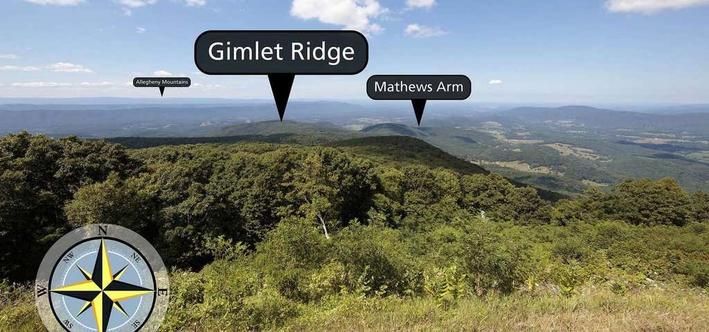
Looking north from an elevation of 3,385 ft (1031 m), Hogback Overlook extends 0.2 miles along Skyline Drive, making it the longest overlook in the Park. Straight ahead is Gimlet Ridge. Gimlet Ridge veers left and descends into the Shenandoah Valley. Veering right from Gimlet Ridge is Mathews Arm. Far in the distance, on a clear day, you may see the Allegheny Mountains.
Be the first to add a review to the Hogback Interpretive Site.
/-107.328288,44.82788,14/300x172@2x?access_token=pk.eyJ1Ijoicm9hZHRyaXBwZXJzIiwiYSI6ImNsdjQ5N2VtZDA2bW8ycW13ZHAxeGhjbjkifQ.UIccpoAxc7g3BAuK4s9vjg)
Hogback Interpretive Site
Hours
Problem with this listing? Let us know.
Has RV parking changed? Let us know.
-
Parking
-
Pets Allowed
-
Restrooms
-
Wifi
-
Wheelchair Accessible
-
Credit Cards Accepted
-
Sites
Campground
Nearby Hotels
Related Trip Guides
- Trip Guide
The ultimate guide to Yellowstone National Park
- 19 Places
- 02:35
- 80 mi
- Trip Guide
The top things to do on a U.S. Route 20 road trip
- 23 Places
- 60:25
- 3,576 mi
- Trip Guide
The top things to do on an I-80 road trip
- 35 Places
- 53:41
- 3,194 mi
- Trip Guide
Road trip along the Oregon Trail: A journey through history
- 31 Places
- 36:24
- 2,114 mi