“the canyons of the escalante!”
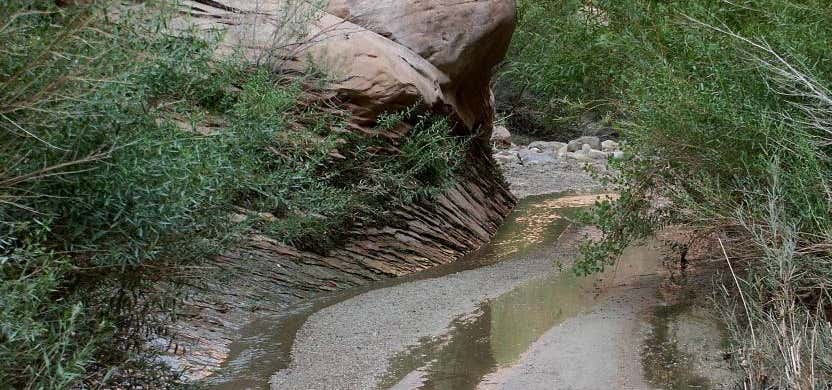
Fortymile Gulch and Willow Gulch are tributaries of the Escalante River, located in Kane County in southern Utah, in the western United States. With a combined length of over 20 miles (30 km), they exhibit many of the geologic features found in the Canyons of the Escalante, including high vertical canyon walls, water pools, narrow slot canyons, domes, and arches. Popular recreational destinations, they are located within the Grand Staircase-Escalante National Monument. The headwaters of Fortymile and Willow Gulches have their origins along a 7 mile (11 km) segment of the Straight Cliffs, the eastern edge of the Kaiparowits Plateau. Intermittent streams merge to form larger branches, then combine to carve a deep canyon up to 500 feet (150 m) into sandstone layers before meeting the main channel of the Escalante River. The northernmost branch is Fortymile Gulch, the historic location of the winter encampment of the San Juan Expedition. Intent on founding a colony in southeastern Utah, they waited at Fortymile Springs in late 1879 while a smaller group prepared a perilous route down to the Colorado River at Hole-in-the-Rock. Nearby is Dance Hall Rock, a scenic dome formed from Entrada sandstone. The lower section of Fortymile Gulch, before it merges with Willow Gulch, is a narrow channel of slot canyons and water pools.

Broken Bow Arch is about a mile down from the Willow Gulch end (which is where the trailhead starts). You can also do some primitive wilderness camping here if you so choose. Prepare to be hiking through lots of water though!
Be the first to add a review to the Fortymile Gulch.
/-110.991,37.333,14/300x172@2x?access_token=pk.eyJ1Ijoicm9hZHRyaXBwZXJzIiwiYSI6ImNsdjQ5N2VtZDA2bW8ycW13ZHAxeGhjbjkifQ.UIccpoAxc7g3BAuK4s9vjg)
Fortymile Gulch
Hours
- Sun - Sat: 12:00 am - 11:59 pm
Problem with this listing? Let us know.
Has RV parking changed? Let us know.
-
Parking
-
Pets Allowed
-
Restrooms
-
Wifi
-
Wheelchair Accessible
-
Credit Cards Accepted
-
Outdoor Seating
Parking, Dining
Nearby Hotels
Related Trip Guides
- Trip Guide
Pay Tribute and Reflect at These US Monuments and Memorials
- 14 Places
- Trip Guide
The ultimate road trip guide to Canyonlands National Park
- 18 Places
- Trip Guide
How to best experience Zion National Park
- 15 Places
- Trip Guide
Road trip to the filming locations of 'Dumb and Dumber'
- 8 Places
- 41:01
- 2,643 mi