Reviews of Lake Creek Dispersed Camping
7 people have reviewed this location
Ratings Summary
Cell Coverage
Verizon 4G/5G
Confirmed by 4 users | Last reported on October 04, 2022AT&T 4G/5G
Confirmed by 3 users | Last reported on October 04, 2022T-Mobile 4G/5G
Confirmed by 2 users | Last reported on October 04, 2022
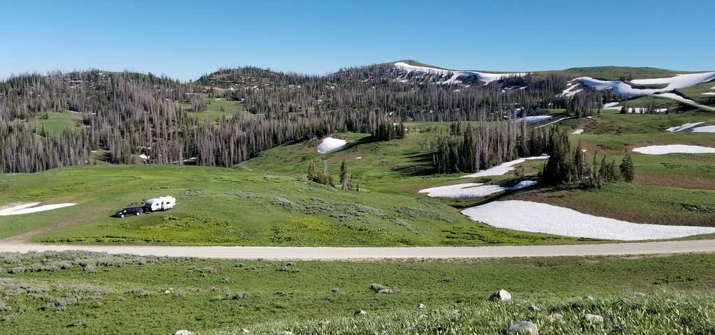
Heber Mountain is not so much a site as it is a broad area, roughly a hundred thousand acres of Uinta-Wasatch-Cache National Forest bounded by UT-35 to the north and US-40 to the south. It's located to the east of Heber City and southeast of the resort town of Park City, Utah. This also includes areas known as Duchesne Ridge and Currant Creek. Numerous Forest Service roads criss-cross this entire area, nearly all of which are legal for dispersed camping. See the Heber-Kamas Ranger District Motor Vehicle Use Map (MVUM) for specifics: https://www.fs.usda.gov/main/uwcnf/maps-pubs. Main Forest Roads in this area are graded gravel, while side roads are usually unmaintained and bumpy.
The area is accessible by heading east on Center Street from downtown Heber, which becomes Lake Creek Road and remains paved for about 12 steep, twisty miles to the National Forest boundary where the road becomes FR-083 and turns to graded gravel. A couple of miles after the pavement ends you'll reach the intersection of FR-054 and FR-083. From here, pick a direction and find a spot. Heading left on FR-054, only street legal vehicles are allowed. Turn right on FR-083 and off-highway ATVs are permitted. Be aware that you can also access the area from the north by turning off UT-35 at Wolf Creek Pass (FR-054 or FR-091), or from the south along US-40 (FR-082 or Currant Creek Road).
Heber Mountain itself sits at the northwest corner of this broad area, a 10,200-foot summit that doesn't look like much because the land surrounding it sits at 9,000-10,000 feet ASL. The summit thus doesn't have much prominence above the surrounding land. For the weekend of July 21-23, 2017 we picked a small knoll at 9,870 feet about a quarter mile due south of Heber Mountain on FR-094 (40.412854 N, -111.1825567 W) that had a rare amenity for this area: 4G on Verizon, two bars! Friends with AT&T had 1 bar and fickle service. If we walked 300 yards from camp we lost service completely. We enjoyed 270-degree views including the Wasatch Mountains to the west, and the High Peaks of the Uinta Mountains to the north. Previous campers left a couple of rock fire rings behind.
We were also camped just around the corner June 23-25, 2017 (40.406491 N, -111.178863 W) where cell service was non-existent at our site. Winter of 2016-17 was a good snow year, and some roads in the area were still impassible in late June due to lingering drifts. This area is used by snowmobilers in winter and these roads are not plowed, the effects of which at this altitude can easily last into early summer. Check with the Heber-Kamas Ranger District of the Uinta-Wasatch-Cache National Forest (435) 654-0470 for current conditions.
I've uploaded photos of both of these campsites we've used in 2017.
In years past we've also camped several times along the West Fork Duchesne River on FR-050 (bumpy and rough), and on the Duchesne Ridge along FR-091 (best access is via a decent dirt road from Wolf Creek Pass, but the further you go from Wolf Creek Pass the worse it gets). If you insist upon actually paying for a campsite, within this area there's even the Mill Hollow Campground (https://www.campendium.com/mill-hollow-campground) and Currant Creek Campground (https://www.campendium.com/currant-creek-campground), although there are no hookups at either so you'll still be dry camping anyway. The possibilities in this area are nearly limitless.
Finally, realize that this is open range where ranchers lease the land for grazing sheep. If you arrive at a site and hear sheep in the distance, consider picking another site, for there's nothing like a few hundred sheep wandering (and pooping) through your campsite. Trust me, I know.
Nightly Rate: $0.00
Days Stayed: 4
Site Number: N/A
Cell Coverage Rating
Verizon 4G
AT&T 4G

Love this area! Stay July 3-4, unfortunately had to leave early due to Dollar Ridge fires. We entered from Hwy 35, turn onto FR 054, 5.7 miles (passing Mill Hollow campground), turn left at Duschesne Ridge sign (marker 091), go up 0.3 miles on the right. The site itself is literally on the ridge and a large trailer will not fit. We had to do some pretty crazy maneuvers to get ours in there. Beautiful, beyond beautiful views once there! Up the road on the same ridge, there are several sites easier access on the left, go on a bit further and there is an amazing site on the right that is almost completely hidden by trees, and one beyond that. Now...after that I would not suggest going on the road becomes extremely narrow and harsh (a guy tore up his truck while we were there). The downsides, our site was tricky to get into, the ground was this volcanic black sand that got everywhere, and the road was dusty. I didn't rate all 5's because of these factors but the area itself is amazing and we have our eyes on another one across the way!
Nightly Rate: $0.00
Days Stayed: 2
Site Number: -

Views were outstanding, though cell service was a little spotty. We stayed up on top of a peak, and service fluctuated from zero bars to 2 bars of 5G. Can get pretty windy, but overall was an amazing, secluded site.
Nightly Rate: $0.00
Days Stayed: 2
Site Number: -
Cell Coverage Rating
AT&T 4G
As mentioned in a previous review, this is not so much a campground as it is an area. We found a GREAT spot overlooking valleys and mountains at 9765 ft ( 40.41468, -111.18082 ) . We had 1-2 bars Verizon and T-MOBILE. Also had 4G lte with our booster. We got our 36 ft Bounder in here but it was difficult. In mid June lows were in the 40s and highs in the 70s.
Nightly Rate: $0.00
Days Stayed: 9
Site Number: Na
Cell Coverage Rating
Verizon 4G
T-Mobile 4G

We did dispersed camping and it was gorgeous. One serious issue though is that people literally leave their rvs and tents up for weeks at a time just saving their spots. ON The small little road we camped on there was an old trailer and a tent set up with no occupants for the entire week. We went on a Wednesday hoping to find a spot and so many were taken and unoccupied. It was frustrating. We ended up right next to the road when we should've been able to go back further.
The week was quiet and nice. With beautiful weather and chilly nights. The weekend on the other hand was very busy with UTVs everywhere. Several campers were also shooting guns which wasn't my favorite.
My husband was trying work remotely and had no signal with verizon and an external antenna. That made it super difficult and we had to shuttle him down to Heber. The road to the area is narrow and winding and steep, be prepared to go slow. We did see all types of trailers up there so I think it's fine for most vehicles. The dirt road wasn't too bad. Sheep herders use the area for grazing so also be prepared to see some cute baby lambs.
Nightly Rate: -
Days Stayed: 6
Site Number: -
Cell Coverage Rating
Verizon
I identified maybe two dozen spots by satellite before we headed out here. They were all occupied. We drove nearly an hour further than we had intended, with a forest map but without satellite as the internet dropped off about 15 minutes in, and I think we got lucky to find anything at all. Looking at the map after the fact we were almost at the reservoir and ours was probably the very last available spot in this area. And then only because we have a high clearance trailer and were able to get into a spot not many would have been able to get up into.
All that said, it was pretty and cool and we'd go back. Just maybe not on a saturday morning.
Nightly Rate: $0.00
Days Stayed: 1
Site Number: Dispersed
Cell Coverage Rating
Verizon
AT&T
T-Mobile
We just arrived tonight. We also camped here 3 years ago. It's an amazing collection of camping opportunities spread over thousands of acres. However, previous reviewers are correct that despite the size of this area, nearly every spot is occupied by trailers that have been left by locals for weeks or month. We saw probably 75 trailers in sites, and only two of them looked occupied (stairs out, or a vehicle present, or camping items outside). Extremely disappointing. All the best spots are taken despite the fact that there's almost nobody here. Rangers need to jump on this.
Nightly Rate: $0.00
Days Stayed: 1
Site Number: 0
Be the first to add a review to the Lake Creek Dispersed Camping.
/-111.18237241152059,40.423034513248496,14/300x172@2x?access_token=pk.eyJ1Ijoicm9hZHRyaXBwZXJzIiwiYSI6ImNsdjQ5N2VtZDA2bW8ycW13ZHAxeGhjbjkifQ.UIccpoAxc7g3BAuK4s9vjg)
Lake Creek Dispersed Camping
Hours
Problem with this listing? Let us know.
Has RV parking changed? Let us know.
-
Parking
-
Pets Allowed
-
Restrooms
-
Wifi
-
Wheelchair Accessible
-
Credit Cards Accepted
- Max Stay
- 14
- Affiliation
- National forest
- Last Nightly Rate
- 0.0
- Lowest Nightly Rate
- 0.0
- Longest Vehicle Length Reported
- 36.0
-
Laundry
-
Propane
-
Showers
-
Big Rigs
-
Boondock
-
Firewood
-
Tent Sites
-
Cabin Sites
-
Full Hookup
-
Paved Sites
-
Dump Station
-
Mobile Homes
-
Public Water
-
Pull Through
-
Reservations
-
Sewer Hookup
-
Water Hookup
-
Age Restricted
-
Dispersed Sites
-
Open Seasonally
-
Permit Required
-
Group Tent Sites
-
Fulltime Residents
-
Standard Tent Sites
-
Pull Through RV Sites
Campground
Nearby Hotels
Related Trip Guides
- Trip Guide
Pay Tribute and Reflect at These US Monuments and Memorials
- 14 Places
- Trip Guide
The ultimate road trip guide to Canyonlands National Park
- 18 Places
- Trip Guide
How to best experience Zion National Park
- 15 Places
- Trip Guide
Road trip to the filming locations of 'Dumb and Dumber'
- 8 Places
- 41:01
- 2,643 mi