“Beginning at the Crater Rim Viewpoint”
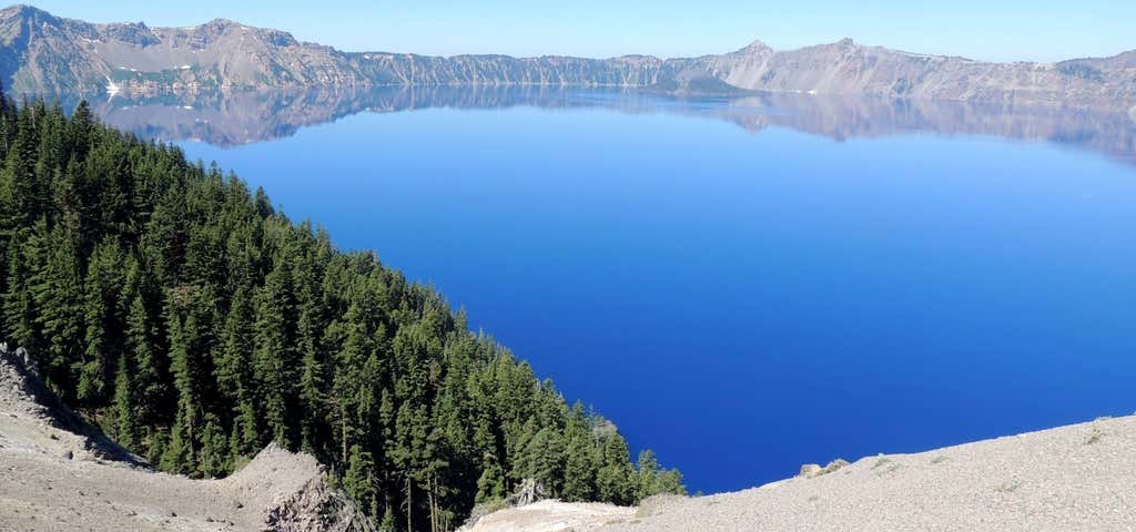
Beginning at the Crater Rim Viewpoint, this section of the Upper Rogue Trail passes through a stand of lodgepole pine. The trees show how hard it is for vegetation to grow on the frothy ash that covered the area when Mt. Mazama erupted over 6,800 years ago. Approximately half a mile after leaving the trailhead, the Boundary Springs Trail intersects with the Upper Rogue River Trail. This trail provides a 7.2 mile link for those wishing to connect with the Pacific Crest Trail. The upper Rogue River Trail continues to the right at this junction and heads downstream. The next two miles offers spectacular views. One vista overlooks a sharp hairpin turn sculpted into the cliff by the river. Just beyond this, Ruth Falls can be heard far below. A steep, unstable pumice cliff prevents more than a glimpse of the falls through the trees. Two miles further downstream, the trail approaches Rough Rider Falls. The trail leaves the river at this point and travels 2.5 miles through the woods, crossing Forest road #6530 and returning to the river's edge at Hamaker Campground on Forest road #900. Directions from Prospect: Travel north on Hwy. 62 until you reach the junction with Hwy. 230. Continue north on Hwy. 230 for approximately 16.5 miles until you reach the Crater Rim Viewpoint. This is where the trail begins.

Beginning at the Crater Rim Viewpoint, this section of the Upper Rogue Trail passes through a stand of lodgepole pine. The trees show how hard it is for vegetation to grow on the frothy ash that covered the area when Mt. Mazama erupted over 6,800 years ago. Approximately half a mile after leaving the trailhead, the Boundary Springs Trail intersects with the Upper Rogue River Trail. This trail provides a 7.2 mile link for those wishing to connect with the Pacific Crest Trail. The upper Rogue River Trail continues to the right at this junction and heads downstream. The next two miles offers spectacular views. One vista overlooks a sharp hairpin turn sculpted into the cliff by the river. Just beyond this, Ruth Falls can be heard far below. A steep, unstable pumice cliff prevents more than a glimpse of the falls through the trees. Two miles further downstream, the trail approaches Rough Rider Falls. The trail leaves the river at this point and travels 2.5 miles through the woods, crossing Forest road #6530 and returning to the river's edge at Hamaker Campground on Forest road #900.
Be the first to add a review to the Upper Rogue Trail (Crater Rim Viewpoint to Hamaker Campground).
/-122.3576519,43.0371699,14/300x172@2x?access_token=pk.eyJ1Ijoicm9hZHRyaXBwZXJzIiwiYSI6ImNsdjQ5N2VtZDA2bW8ycW13ZHAxeGhjbjkifQ.UIccpoAxc7g3BAuK4s9vjg)
Upper Rogue Trail (Crater Rim Viewpoint to Hamaker Campground)
Hours
Problem with this listing? Let us know.
Has RV parking changed? Let us know.
-
Parking
-
Pets Allowed
-
Restrooms
-
Wifi
-
Wheelchair Accessible
-
Credit Cards Accepted
Nearby Hotels
Click to find bookable tours and activities here
Related Trip Guides
- Trip Guide
A road trip to filming locations featured in 'The Goonies'
- 6 Places
- 00:57
- 28 mi
- Trip Guide
The Ultimate Guide to Crater Lake National Park
- 15 Places
- Trip Guide
- Weekend
Pacific Coast Highway: Oregon - Washington
- 30 Places
- 17:36
- 670 mi
- Trip Guide
The top things to do on a U.S. Route 20 road trip
- 23 Places
- 60:25
- 3,576 mi