“follows the bank along a picturesque and diverse river section”
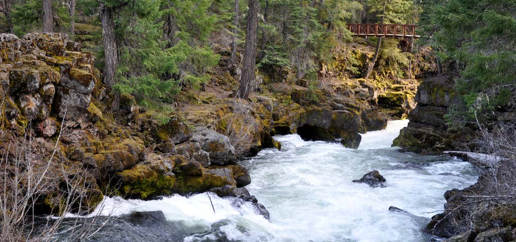
Natural Bridge, a feature with geologic, historic and scenic interest, marks the beginning of this 3.5 mile section of the Upper Rogue Trail. The route follows the bank along a picturesque and diverse section of the Rogue River. At Natural Bridge, the river is swallowed by an underground maze of lava tubes. A fraction of the flow is released into a small pool directly below the bridge. The remainder of the diverted water surges back to the surface and is visible from the viewpoint bridge. The largest of these angles out from under the east bank into the main channel, returning the river to its full strength. The trail begins one-half mile west of Highway 62, near the Natural Bridge Viewpoint bridge. The route winds along the bank over a rough tread of mossy lava rock which becomes very slippery in wet weather. Vegetation along the trail alternates between sheltering old-growth forest and brush, while the river's character varies between rapids and pools of quiet water. The trail climbs high above the river where it bends sharply and rages through the narrow chute of a collapsed lava tube. This beautiful rapids is known as Knob Falls. As the trail approaches Woodruff Bridge, several old skid roads are encountered. A developed picnic area is available at Woodruff Bridge. This is also a favorite fishing spot. Please use caution around the water - the river is dangerous due to extremely cold water and a strong, forceful current. Directions from Prospect: Travel north on Highway 62 to the trailhead, located next to eh Natural Bridge Campground half a mile west of the Highway.

Natural Bridge, a feature with geologic, historic and scenic interest, marks the beginning of this 3.5 mile section of the Upper Rogue Trail. The route follows the bank along a picturesque and diverse section of the Rogue River. At Natural Bridge, the river is swallowed by an underground maze of lava tubes. A fraction of the flow is released into a small pool directly below the bridge. The remainder of the diverted water surges back to the surface and is visible from the viewpoint bridge. The largest of these angles out from under the east bank into the main channel, returning the river to its full strength. The trail begins one-half mile west of Highway 62, near the Natural Bridge Viewpoint bridge. The route winds along the bank over a rough tread of mossy lava rock which becomes very slippery in wet weather. Vegetation along the trail alternates between sheltering old-growth forest and brush, while the river's character varies between rapids and pools of quiet water. The trail climbs high above the river where it bends sharply and rages through the narrow chute of a collapsed lava tube. This beautiful rapids is known as Knob Falls. As the trail approaches Woodruff Bridge, several old skid roads are encountered. A developed picnic area is available at Woodruff Bridge. This is also a favorite fishing spot. Please use caution around the water - the river is dangerous due to extremely cold water and a strong, forceful current.
Be the first to add a review to the Upper Rogue Trail (Natural Bridge Viewpoint to Woodruff Bridge).
/-122.4654744,42.8998564,14/300x172@2x?access_token=pk.eyJ1Ijoicm9hZHRyaXBwZXJzIiwiYSI6ImNsdjQ5N2VtZDA2bW8ycW13ZHAxeGhjbjkifQ.UIccpoAxc7g3BAuK4s9vjg)
Upper Rogue Trail (Natural Bridge Viewpoint to Woodruff Bridge)
Hours
Problem with this listing? Let us know.
Has RV parking changed? Let us know.
-
Parking
-
Pets Allowed
-
Restrooms
-
Wifi
-
Wheelchair Accessible
-
Credit Cards Accepted
Nearby Hotels
Related Trip Guides
- Trip Guide
A road trip to filming locations featured in 'The Goonies'
- 6 Places
- 00:57
- 28 mi
- Trip Guide
The Ultimate Guide to Crater Lake National Park
- 15 Places
- Trip Guide
- Weekend
Pacific Coast Highway: Oregon - Washington
- 30 Places
- 17:36
- 670 mi
- Trip Guide
The top things to do on a U.S. Route 20 road trip
- 23 Places
- 60:25
- 3,576 mi