“flowing through miles of old growth forest”
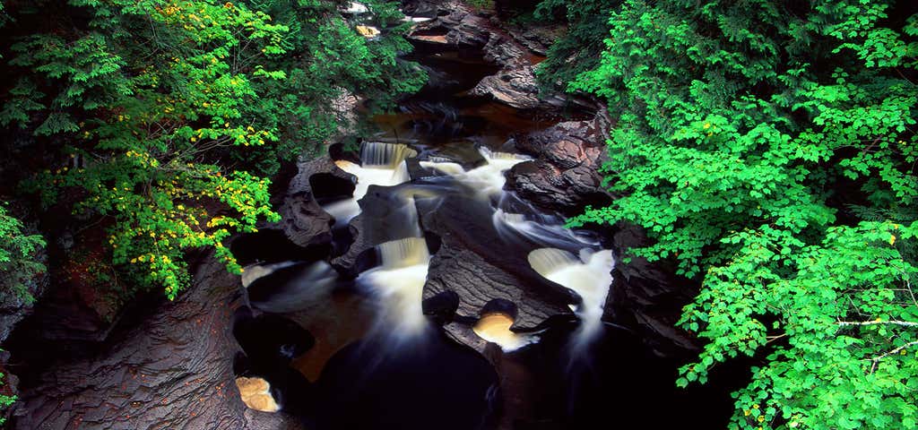
The Presque Isle River runs 42.1 miles (67.8 km) through the Upper Peninsula of Michigan and empties into Lake Superior. Along its course, it flows through the Ottawa National Forest and Porcupine Mountains Wilderness State Park. It has 300 square miles (780 km2) of drainage area in Upper Michigan and northern Wisconsin. The Presque Isle River within this area traverses a series of low falls and cascades, before dividing into two swifter and narrower channels that cut deeply into the underlying bedrock. The surrounding forest is dominated by old growth sugar maple, hemlock, and white pine.

This is not the correct location of the Presque Isle River.
Be the first to add a review to the Presque Isle River.
/-83.4838174,45.34406,14/300x172@2x?access_token=pk.eyJ1Ijoicm9hZHRyaXBwZXJzIiwiYSI6ImNsdjQ5N2VtZDA2bW8ycW13ZHAxeGhjbjkifQ.UIccpoAxc7g3BAuK4s9vjg)
Presque Isle River
Hours
Problem with this listing? Let us know.
Has RV parking changed? Let us know.
-
Parking
-
Pets Allowed
-
Restrooms
-
Wifi
-
Wheelchair Accessible
-
Credit Cards Accepted
Nearby Hotels
Related Trip Guides
- Trip Guide
The Great Northern is a 3,600 mile, cross-country odyssey
- 57 Places
- 69:15
- 3,565 mi
- Trip Guide
Gone But Not Forgotten: Former National Parks
- 7 Places
- Trip Guide
The top things to do on a Tunnel of Trees road trip
- 12 Places
- 00:51
- 31 mi
- Trip Guide
The top things to do on an I-75 road trip
- 34 Places
- 31:05
- 1,933 mi