“Hike to rugged beaches & tidepools”
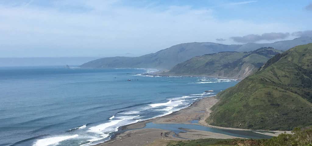
Along the northern coast of California, civilization has left its mark on all but the most rugged or remote stretches of coastline. One stretch that is largely untouched by major highways and towns is the 60,000-acre King Range National Conservation Area. Extremely steep and rocky terrain extends to the beach, and forced the coastal highway (combined Highways 1 and 101) about 30 miles inland from the King Range. The remote region is known as California's Lost Coast, accessed by only a few back roads. The 20-acre Mattole Recreation Site is at the northern tip of the conservation area, where the Mattole River meets the Pacific Ocean. The Mattole River is the major inland collection point for 39 tributary streams, and drains 300 square miles of watershed. Its 100-acre estuary is important to migrating birds and shorebirds, providing the only protected wetland habitat along many miles of rugged coast. Wildlife of various kinds are attracted by the lush riverside vegetation, the beach, offshore rocks and the sea beyond. The Mattole Recreation Site is also at the north end of the Lost Coast Trail, one of the few coastal wilderness hiking experiences in the U.S. The trail is considered one of the most attractive features of the conservation area - but it is a rugged hike, not a stroll on the beach. The beach is narrow, and at some points it disappears under rock slides or at rocky points that jut out into the surf. Take the Honeydew exit from Highway 101 (about 25 miles north of Garberville). Turn left on Bull Creek/Mattole Road and drive 22 miles. At Honeydew, turn west toward Petrolia and drive 13.5 miles. Before crossing the river, turn west on Lighthouse Road. Drive five miles to the parking area.OR: From Ferndale, take Petrolia Road 30 miles to Petrolia. Go 3/4 mile past Petrolia, cross the river and turn west onto Lighthouse Road, continue five miles to parking area.-Note: be careful along the long drive from Highway 101, often on narrow, winding, steep paved roads. The drive is not a recommended from motor homes or vehicles with long trailers.
Reviews

This is an absolutely stunning beach area that seems to go on forever, with a rustic but very pleasant campground with limited spaces. The campground is situated close enough to the beach to hear the pounding waves, but protected by a sand bluff that blocks wind that might come from off the water. It would have been great to spend more time here and take in the beauty and ruggedness of the place, but having the opportunity to see this place first hand, after a friend recommended it, was sufficient so that I can definitely plan a longer trip next time. While it is a bit of a trek off the 101 to get to Mattole, as it's about 40 miles on very twisty, narrow, steep and not the smoothest of roads that rise and fall with the geography. Most definitely worth the drive - especially on a motorcycle, but probably not so much with an RV.

If you want to spend a lovely day walking at the beach and enjoying yourselves playing with the sand, then Mattole Recreation Area is what you are looking for.
This place combines sea relaxation and hiking together. So, if you are an adventurous person like me and my family are, then take the trail provided and watch the birds and the nature during our hike.
Beautiful place and especially watching the sunset drowning at the sea water.
Be the first to add a review to the Mattole Recreation Area.
/-124.355675,40.288848,14/300x172@2x?access_token=pk.eyJ1Ijoicm9hZHRyaXBwZXJzIiwiYSI6ImNsdjQ5N2VtZDA2bW8ycW13ZHAxeGhjbjkifQ.UIccpoAxc7g3BAuK4s9vjg)
Mattole Recreation Area
Hours
Problem with this listing? Let us know.
Has RV parking changed? Let us know.
-
Parking
-
Pets Allowed
-
Restrooms
-
Wifi
-
Wheelchair Accessible
-
Credit Cards Accepted
Nearby Hotels
Related Trip Guides
- Trip Guide
Pay Tribute and Reflect at These US Monuments and Memorials
- 14 Places
- Trip Guide
The Ultimate Guide To Joshua Tree National Park
- 53 Places
- 11:44
- 408 mi
- Trip Guide
The top things to do on an I-40 road trip
- 35 Places
- 49:44
- 2,851 mi
- Trip Guide
The top things to do on an I-10 road trip
- 55 Places
- 56:13
- 3,026 mi