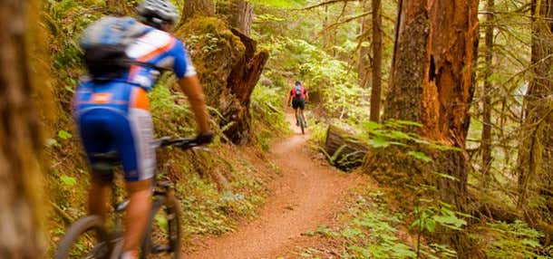

This is the signature trail ride in Oregon, rated the #1 trail in the nation by a national cycling magazine. It’s 26 miles of beauty and challenge, offering sections that are appropriate and challenging for everyone from the weekend cruiser to the thrill junkie.
The top-end trailhead starts just off Highway 126 about a mile above Clear Lake; there’s an off-road parking lot. Most people ride this one-way (usually downhill from the top) in groups, using shuttle vehicles; soloists can try a hitchhiking solution, ride it all the way down and back (a long day) or pick a shorter segment to ride out-and-back.
The trail starts in deep forest and soon presents a choice of routes around Clear Lake. Go east (left) to take the challenging route through loose lava rock, some paved trail (but not easy, actually) and along the rugged edge of the lake. You’ll go right by the spring pool that feeds the lake and the McKenzie River. The west fork is much gentler.
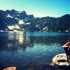
After Clear Lake you’ll cross the highway and start a section of technical trail through the forest – roots, rocks, small ledges and lava rocks make this a good challenge. Don’t be too foolish to get off the bike for a couple stretches. You’ll pass Sahalie and Koosah Falls, and eventually lose the river as it submerges below ground. After a bit, you’ll see Tamolitch Pool, a serene bloe pool where the river re-emerges. There are rocks above the pool perfect for stopping for a food break.
As you continue on, there are some more technical stretches, but eventually the trail becomes more intermediate. There are some awesome segments where you can glide through the trees, slaloming like a ski run without touching the brakes for hundreds of yards at a time. There are multiple stream crossings, all with bridges; many of them are made of huge logs and present a serious can-you-ride-this challenge for the adrenaline lovers.
The bottom section is much less technical than the top, but still presents some climbs and plenty of surreal scenery.
The trail crosses roads and jogs around a bit, but it’s signed well enough to keep you on track. There are multiple entry points from Highway 126; check with the ranger station in McKenzie Bridge for advice if you want a partial ride.
This is (overall) downhill, but it’s not necessarily a trail where you’ll make fast time. Allow four to five hours top to bottom unless you’re in a hurry. And on this trail, you shouldn’t be.
More info: http://rideoregonride.com/trails/mckenzie-river-trail/
With Tamolitch Pool to hike to, this is one of the greatest trails with the best treat at the end!!
Be the first to add a review to the McKenzie River Trail.
/-122.116127,44.17928,14/300x172@2x?access_token=pk.eyJ1Ijoicm9hZHRyaXBwZXJzIiwiYSI6ImNsdjQ5N2VtZDA2bW8ycW13ZHAxeGhjbjkifQ.UIccpoAxc7g3BAuK4s9vjg)
McKenzie River Trail
Hours
Problem with this listing? Let us know.
Has RV parking changed? Let us know.
-
Parking
-
Pets Allowed
-
Restrooms
-
Wifi
-
Wheelchair Accessible
-
Credit Cards Accepted
Nearby Hotels
Related Trip Guides
- Trip Guide
A road trip to filming locations featured in 'The Goonies'
- 6 Places
- 00:57
- 28 mi
- Trip Guide
The Ultimate Guide to Crater Lake National Park
- 15 Places
- Trip Guide
- Weekend
Pacific Coast Highway: Oregon - Washington
- 30 Places
- 17:36
- 670 mi
- Trip Guide
The top things to do on a U.S. Route 20 road trip
- 23 Places
- 60:25
- 3,576 mi