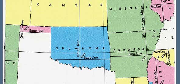
The Indian meridian, in longitude 97° 14′ 30″ west from Greenwich, extends from Red River to the south boundary of Kansas, and, with the base line in latitude 34° 30′ north, governs the surveys in Oklahoma east of 100° west longitude from Greenwich (all of Oklahoma except the Oklahoma panhandle). This line was chosen arbitrarily as part of the land survey of 1870 conducted by E. N. Darling and Thomas H. Barrett, at an arbitrary point about one mile south of Fort Arbuckle (about six miles west of present Davis, Oklahoma). From this initial point, the north-south line was designated as the Indian meridian and the East–West line was designated as the Indian baseline. The Indian Meridian initial point is listed in the National Register of Historic Places with ID #70000533.
Be the first to add a review to the Indian meridian.
/-97.24754444444444,34.50678888888889,14/300x172@2x?access_token=pk.eyJ1Ijoicm9hZHRyaXBwZXJzIiwiYSI6ImNsdjQ5N2VtZDA2bW8ycW13ZHAxeGhjbjkifQ.UIccpoAxc7g3BAuK4s9vjg)
Indian meridian
Hours
Problem with this listing? Let us know.
Has RV parking changed? Let us know.
-
Parking
-
Pets Allowed
-
Restrooms
-
Wifi
-
Wheelchair Accessible
-
Credit Cards Accepted
Nearby Hotels
Related Trip Guides
- Trip Guide
The top things to do on an I-40 road trip
- 35 Places
- 49:44
- 2,851 mi
- Trip Guide
Gone But Not Forgotten: Former National Parks
- 7 Places
- Trip Guide
- 1 Week
The top things to do on a Route 66 road trip
- 41 Places
- 38:08
- 2,284 mi