“Great for skiers and hikers alike”
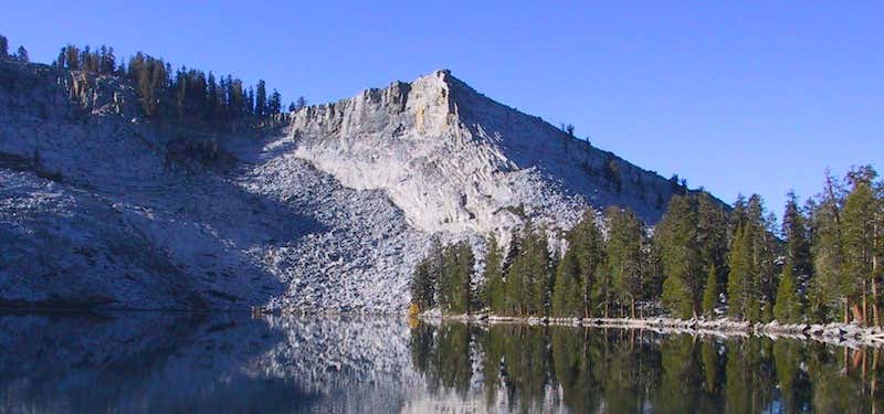
Ostrander Lake is located in Yosemite National Park, approximately 10 miles south of Yosemite Valley and 10 miles east of the Badger Pass Ski Area, at an elevation of 8,500 feet. The lake is a popular destination for cross-country skiers during the winter. It is the primary source of Bridalveil Creek, which feeds Bridalveil Falls. The hike to Ostrander Lake is a long and strenuous 12.7 miles (20.4 km) roundtrip hike starting from the trailhead located just after Bridalveil Creek on the Glacier Point road.[2] The hike begins with a fairly level path through an extensive burned over and regrowth area, with both shaded and sunny areas. The second half of the hike climbs, steeply at times, over 1,500 feet (460 m) in elevation in about 3 miles. Hikers will have a nice view of Clark Range before dropping down to the north shore of the lake. Several excellent campsites can be found on the west side of the lake, particularly on the benches overlooking the rocky ridge that forms the eastern shore backdrop. Fishing is fair for 10-12" rainbow trout. In the summer, the lake is a great backpacking destination because the ski hut is unoccupied but its presence keeps away the hordes of hikers looking for a "wilderness" destination. The lake is named for a descendant of Alexander Ostrander (1783) of Smithfield NY. This branch of Ostrander family settled in Colorado (Georgetown, Granby, Hot Sulphur Springs, Golden) prior to 1872, and some moved from Colorado to California.
Reviews
Be the first to add a review to the Ostrander Lake.
/-119.550556,37.624444,14/300x172@2x?access_token=pk.eyJ1Ijoicm9hZHRyaXBwZXJzIiwiYSI6ImNsdjQ5N2VtZDA2bW8ycW13ZHAxeGhjbjkifQ.UIccpoAxc7g3BAuK4s9vjg)
Ostrander Lake
Hours
Problem with this listing? Let us know.
Has RV parking changed? Let us know.
-
Parking
-
Pets Allowed
-
Restrooms
-
Wifi
-
Wheelchair Accessible
-
Credit Cards Accepted
Nearby Hotels
Related Trip Guides
- Trip Guide
Pay Tribute and Reflect at These US Monuments and Memorials
- 14 Places
- Trip Guide
The Ultimate Guide To Joshua Tree National Park
- 53 Places
- 11:44
- 408 mi
- Trip Guide
The top things to do on an I-40 road trip
- 35 Places
- 49:44
- 2,851 mi
- Trip Guide
The top things to do on an I-10 road trip
- 55 Places
- 56:13
- 3,026 mi