“let this sink in”
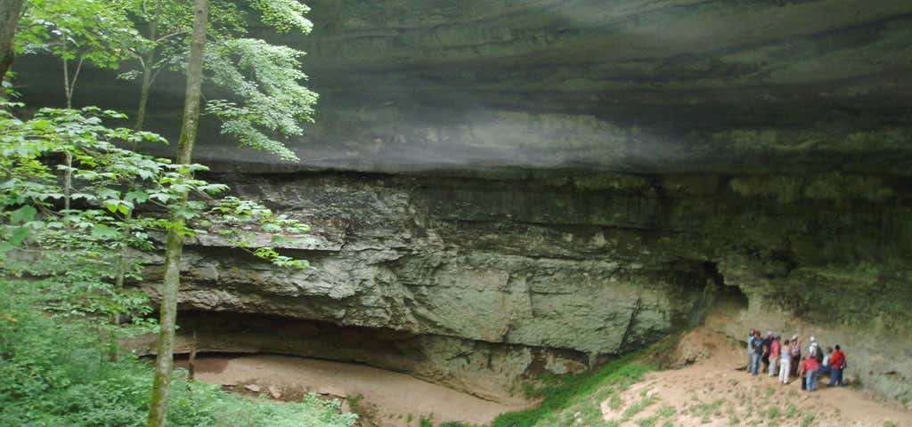
Distance: 1.6 miles round trip Location: Located on Cedar Sink Rd/Highway 422, about .6 miles from highway 70, 3.2 miles north of the intersection with the visitor center road The Cedar Sink Trail leads down hill through second growth forest, past several sinking streams and abundant wildflowers in the spring. At the end of the trail you can view Cedar Sink from a platform or descend down into this enormous sinkhole, where, in times of adequate rainfall, water emerges as a spring from one cave system and a few hundred feet later sinks into another cave. The large sinkhole shows clearly the layers of sandstone and limestone and provides an excellent opportunity to discuss karst geology.
Reviews

Go down the cedar sink trail and keep right when the loop starts. About halfway down the trail there's a small trail to the right that leads to a sinkhole cliff. That's where most of the pictures were taken. If you hug the cliff, you can keep walking for 1/4 mile to more and more sinkhole cliffs. Eventually you'll pop out at a really big one. Hike uphill out of the sinkhole and you'll pop out at a small trail that will take you back to the main trail. Much cooler than the cave tours in my opinion.

I like a hike that has really cool stuff to see along the way, and this fits the bill. There's a river as well. It's a pretty easy hike, but if you're averse to stairs be warned-- there re quite a few!

This was a good hike through a pretty forest, and maybe it was when we came, but I had expected to be able to see the water moving and instead it looked like a dirty pond in a sinkhole. It was still cool, but I wish I'd managed my expectations a bit better.
Be the first to add a review to the Cedar Sink - Mammoth Cave NP.
/-86.153546,37.149628,14/300x172@2x?access_token=pk.eyJ1Ijoicm9hZHRyaXBwZXJzIiwiYSI6ImNsdjQ5N2VtZDA2bW8ycW13ZHAxeGhjbjkifQ.UIccpoAxc7g3BAuK4s9vjg)
Cedar Sink - Mammoth Cave NP
Hours
Problem with this listing? Let us know.
Has RV parking changed? Let us know.
-
Parking
-
Pets Allowed
-
Restrooms
-
Wifi
-
Wheelchair Accessible
-
Credit Cards Accepted
Nearby Hotels
Related Trip Guides
- Trip Guide
The ultimate guide to Mammoth Cave National Park
- 10 Places
- Trip Guide
The ultimate guide to Mammoth Cave National Park
- 10 Places
- Trip Guide
Pay Tribute and Reflect at These US Monuments and Memorials
- 14 Places
- Trip Guide
Gone But Not Forgotten: Former National Parks
- 7 Places