“steady uphill climb to Tumble Ridge”
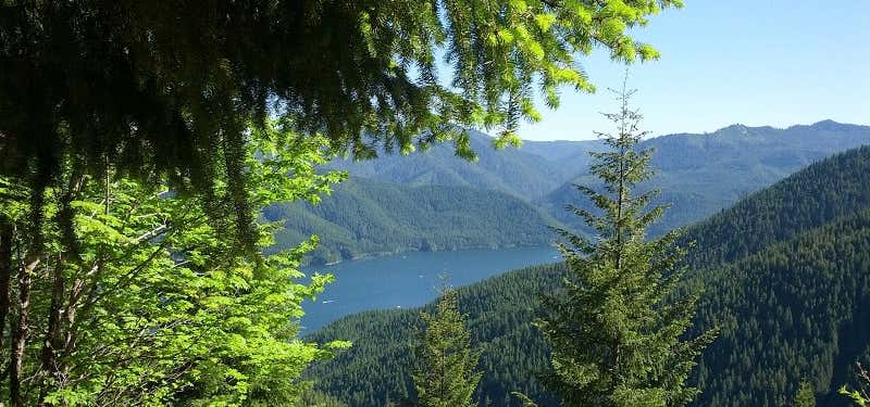
Tumble Ridge Trail #3380 is a moderate 5.3 mile hike at an elevation of 1,600 feet. This trail is steady uphill climb to Tumble Ridge and passes through second growth Douglas-fir and some old growth forest. The trail travels through open stretches on the ridge. Along the way there will be views of Mt. Jefferson, Detroit Lake and Tumble Creek Canyon. Access trail #3379 to reach Tumble Lake and Trail #3381 to Dome Rock. Directions from Detroit: Travel west on Hwy. #22 for approximately 2 miles to trailhead located at Tumble Creek crossing (just west of the Ranger Station.)

Tumble Ridge Trail #3380 is a moderate 5.3 mile hike at an elevation of 1,600 feet. This trail is steady uphill climb to Tumble Ridge and passes through second growth Douglas-fir and some old growth forest. The trail travels through open stretches on the ridge. Along the way there will be views of Mt. Jefferson, Detroit Lake and Tumble Creek Canyon. Access trail #3379 to reach Tumble Lake and Trail #3381 to Dome Rock.
Be the first to add a review to the Tumble Ridge Trail.
/-122.1889989,44.7192413,14/300x172@2x?access_token=pk.eyJ1Ijoicm9hZHRyaXBwZXJzIiwiYSI6ImNsdjQ5N2VtZDA2bW8ycW13ZHAxeGhjbjkifQ.UIccpoAxc7g3BAuK4s9vjg)
Tumble Ridge Trail
Hours
Problem with this listing? Let us know.
Has RV parking changed? Let us know.
-
Parking
-
Pets Allowed
-
Restrooms
-
Wifi
-
Wheelchair Accessible
-
Credit Cards Accepted
Nearby Hotels
Related Trip Guides
- Trip Guide
A road trip to filming locations featured in 'The Goonies'
- 6 Places
- 00:57
- 28 mi
- Trip Guide
The Ultimate Guide to Crater Lake National Park
- 15 Places
- Trip Guide
- Weekend
Pacific Coast Highway: Oregon - Washington
- 30 Places
- 17:36
- 670 mi
- Trip Guide
The top things to do on a U.S. Route 20 road trip
- 23 Places
- 60:25
- 3,576 mi