“steep side slopes”
This trail is open to foot and horse traffic only since it is located within the Wenaha-Tucannon Wilderness. The trail from Oregon Butte to Lodgepole Spring is easy to follow but it is rough. From Lodgepole to Twin Springs, the trail is more difficult to follow and travelers should use caution. From Twin Springs to Fairview Bar on the Wenaha River, the trail is in a fair state of maintenance and easy to follow. Much of the whole trail follows along ridge tops until it makes it's final descent into the Wenaha. On the lower sections of the trail, rattlesnakes may be encountered. Smooth Ridge is the most scenic trail in the Wenaha- Tucannon Wilderness. Views include the Crooked Fork drainage, the Seven Devils in Idaho, the Wallowas in Oregon, and the Wenaha drainage. There are many view points along the trail where Butte Creek, Third Creek and Trout Creek Canyons can be seen. From Oregon Butte, the Tucannon drainage and areas to the north are visible. There are numerous camp sites along the trail at the springs. There are also many dry camps. Water from the springs along the trail is used by most hikers and campers. Directions from Dayton: Take the Patit Road to Eckler Mountain. Follow road about 15 miles. Where there is a stone monument at a Y in the road, turn right on to Kendall Skyline Road #46 for 12 miles to Godman Guard Station. Turn left below Godman on to Road #4608. Take all main right turns for 5 miles to Teepee Trailhead. From Teepee, follow the trail to Oregon Butte-about 3 miles. Smooth Trail takes the east side of Oregon Butte to the south.

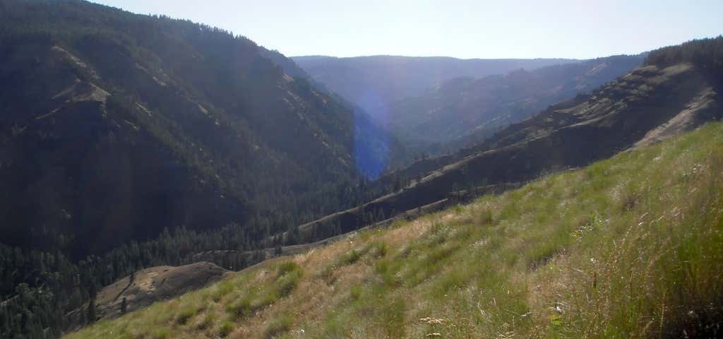
This trail is open to foot and horse traffic only since it is located within the Wenaha-Tucannon Wilderness. The trail from Oregon Butte to Lodgepole Spring is easy to follow but it is rough. From Lodgepole to Twin Springs, the trail is more difficult to follow and travelers should use caution. From Twin Springs to Fairview Bar on the Wenaha River, the trail is in a fair state of maintenance and easy to follow. Much of the whole trail follows along ridge tops until it makes it's final descent into the Wenaha. On the lower sections of the trail, rattlesnakes may be encountered. Smooth Ridge is the most scenic trail in the Wenaha- Tucannon Wilderness. Views include the Crooked Fork drainage, the Seven Devils in Idaho, the Wallowas in Oregon, and the Wenaha drainage. There are many view points along the trail where Butte Creek, Third Creek and Trout Creek Canyons can be seen. From Oregon Butte, the Tucannon drainage and areas to the north are visible. There are numerous camp sites along the trail at the springs. There are also many dry camps. Water from the springs along the trail is used by most hikers and campers.
Be the first to add a review to the Smooth Ridge Trail.
/-117.7544452,46.1661384,14/300x172@2x?access_token=pk.eyJ1Ijoicm9hZHRyaXBwZXJzIiwiYSI6ImNsdjQ5N2VtZDA2bW8ycW13ZHAxeGhjbjkifQ.UIccpoAxc7g3BAuK4s9vjg)
Smooth Ridge Trail
Hours
Problem with this listing? Let us know.
Has RV parking changed? Let us know.
-
Parking
-
Pets Allowed
-
Restrooms
-
Wifi
-
Wheelchair Accessible
-
Credit Cards Accepted
Nearby Hotels
Related Trip Guides
- Trip Guide
The Great Northern is a 3,600 mile, cross-country odyssey
- 57 Places
- 69:15
- 3,565 mi
- Trip Guide
- Weekend
Pacific Coast Highway: Oregon - Washington
- 30 Places
- 17:36
- 670 mi
- Trip Guide
The ultimate guide to North Cascades National Park
- 13 Places
- Trip Guide
Olympic National Park is 1,400 sq miles of primeval beauty
- 14 Places