“beautiful erosional landscape”
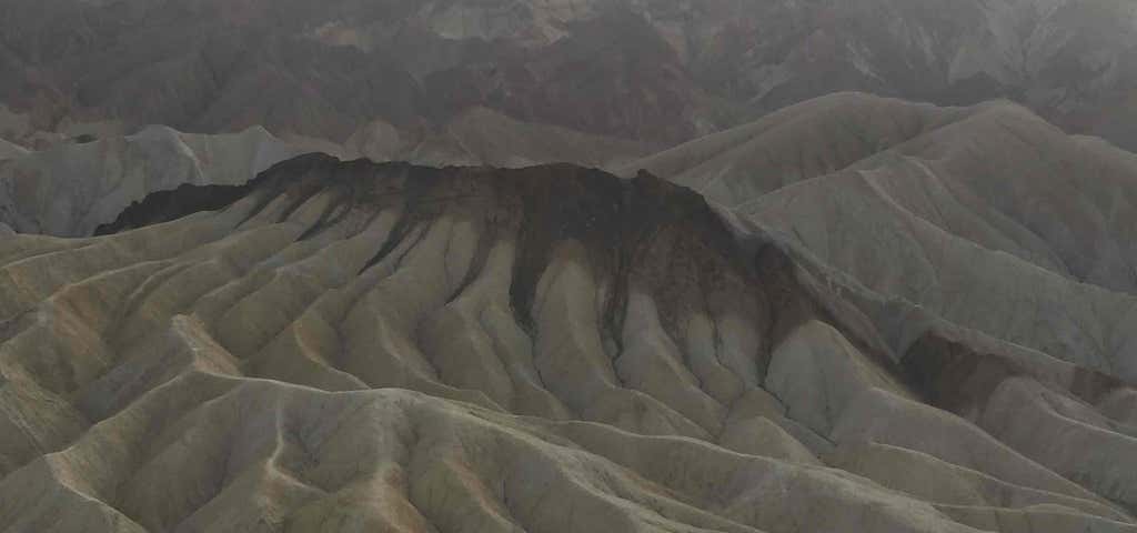
Zabriskie Point is a part of Amargosa Range located in east of Death Valley in Death Valley National Park in the United States noted for its erosional landscape. It is composed of sediments from Furnace Creek Lake, which dried up 5 million years ago—long before Death Valley came into existence. Millions of years prior to the actual sinking and widening of Death Valley and the existence of Lake Manly (see Geology of the Death Valley area), another lake covered a large portion of Death Valley including the area around Zabriskie Point. This ancient lake began forming approximately nine million years ago. During several million years of the lake's existence, sediments were collecting at the bottom in the form of saline muds, gravels from nearby mountains, and ashfalls from the then-active Black Mountain volcanic field. These sediments combined to form what we today call the Furnace Creek Formation. The climate along Furnace Creek Lake was dry, but not nearly as dry as in the present. Camels, mastodons, horses, carnivores, and birds left tracks in the lakeshore muds, along with fossilized grass and reeds. Borates, which made up a large portion of Death Valley's historical past were concentrated in the lakebeds from hot spring waters and alteration of rhyolite in the nearby volcanic field. Weathering and alteration by thermal waters are also responsible for the variety of colors represented there. Regional mountains building to the west influenced the climate to become more and more arid, causing the lake to dry up, and creating a dry lake. Subsequent widening and sinking of Death Valley and the additional uplift of today's Black Mountains tilted the area. This provided the necessary relief to accomplish the erosion that produced the badlands we see today. The dark-colored material capping the badland ridges (to the left in the panoramic photograph) is lava from eruptions that occurred three to five million years ago. This hard lava cap has retarded erosion in many places and possibly explains why Manly Beacon, the high outcrop to the right, is much higher than other portion of the badlands. Manly Beacon was named in honor of William L. Manly, who along with John Rogers, guided members of the ill-fated Forty-niners out of Death Valley during the gold rush of 1849.
I loved this place! Easy parking lot and restroom access. Walk up the short hill for a beautiful scenic view of the powers of erosion and the wonderful colorful layers of sediment. The river that runs through the canyons dried up 5 million years ago... meaning you can totally and should take a hike down if you're up for an adventure! It seriously feels like Mars or another planet down there walking on the dried river bed.

We stopped here for a break on our way to Death Valley National Park. There’s a little car park and beyond is a 1/4 mile walk to a viewing point which overlooks miles and miles of awesome rock formations that reveal centuries of Earth’s history... its really something to experience!

Absolutely beautiful. It's not too hard to get up the walking path and it's totally worth it to make a stop here.

Nice viewpoint. Quite touristic though (and this was in winter) and there wasn’t necessarily something we didn’t already see from the road
Beautiful views, easy walk from the parking area

Amazing view. Awe inspiring.

This place is awesome.... Didn't have to go far to get some really decent photos.

Awesome view. Worth the walk up a hill to see

A beautiful look out with a well paved path. Handicap accessible.
Be the first to add a review to the Zabriskie Point.
/-116.81007399283,36.4185199924649,14/300x172@2x?access_token=pk.eyJ1Ijoicm9hZHRyaXBwZXJzIiwiYSI6ImNsdjQ5N2VtZDA2bW8ycW13ZHAxeGhjbjkifQ.UIccpoAxc7g3BAuK4s9vjg)
Zabriskie Point
Hours
Problem with this listing? Let us know.
Has RV parking changed? Let us know.
-
Parking
-
Pets Allowed
-
Restrooms
-
Wifi
-
Wheelchair Accessible
-
Credit Cards Accepted
Nearby Hotels
Related Trip Guides
- Trip Guide
Pay Tribute and Reflect at These US Monuments and Memorials
- 14 Places
- Trip Guide
The Ultimate Guide To Joshua Tree National Park
- 53 Places
- 11:44
- 408 mi
- Trip Guide
The top things to do on an I-40 road trip
- 35 Places
- 49:44
- 2,851 mi
- Trip Guide
The top things to do on an I-10 road trip
- 55 Places
- 56:13
- 3,026 mi