“An amazing geological gem”
Seven Teacups is a short section of Dry Meadow Creek just before it joins the Kern River and is one of the best Class C canyons. This canyon is best descended in summer or fall, or whenever the flow is not extremely high as there are flow-related challenges. The technical descent is relatively short and, because the terrain is relatively forgiving with short jumps and multiple escape points, this canyon makes for a perfect practice ground before attempting longer and more difficult Class C Sierra canyons.
There are multiple approaches to Seven Teacups.
Brennen
Described by Chris Brennen, this route starts at the Jeep trail at 35.9766°, -118.4996° and follows a sometimes-faint trail with full sun exposure 1.83 miles to the first water of Dry Meadow Creek. It can be difficult to navigate, so a GPS is recommended. After the initial 300ft of elevation gain on a 13% grade, the remainder of the route is slightly down hill with a few ups and downs as one navigates along the dry gully. This approach has the least amount of hiking, but most sections of it is cross country which can be quite hard if there has not been any forest fire in a while. Full loop For canyoneers without access to two cars to make the shuttle, the road from Johnsondale Bridge to the start of the Brennen approach adds 1.4 miles and 500ft of elevation gain for a total approach of 3.3 miles and 800ft of elevation gain. This has the worst of both worlds and is definitely not recommended.
Bottom-up
The easier and most popular approach is bottoms up. Instead of the Brennen route which circles around the hills on the west side of the Kern, Seven Teacups can also be approached by reversing the exit route to the confluence of Dry Meadow Creek with the Kern, going slightly farther upstream and crossing the Kern (be careful of Respect, a class IV+ rapid a short distance downstream of the Dry Meadow Creek confluence), then climbing steeply (34% grade) 300ft up the west bank of the Kern around the Seven Teacups section on its north side. This bypass route is shown in orange on the map and enters Dry Meadow Creek shortly before the Seven Teacups section, bypassing 0.18 miles of creek travel in Dry Meadow Creek relative to the Brennen approach. This approach is 2.55 miles long and has slightly over 500ft of elevation gain.
When the flow of the Kern is strong, setting a rope across the river may aid in crossing it. Again, be careful of the class IV+ rapid just downstream of the Dry Meadow Creek confluence. 3rd Class Variation A slight variation to the Bottom-up approach is to climb the knobby face directly to the north of the canyon. Amazing knobs and good friction makes this steep face an extremely pleasant climb for those that are equipped with good shoes and are comfortable with some exposure. Once on the top of the face, continue past some bushes and trees to a (comparatively) featureless slab. Climb the shallow gulley on the left (4th Class), or trend right and climb the obvious right facing dihedral (3rd Class) to the top. From here, you can traverse left back to the water course, dropping in wherever you desire.
4WD
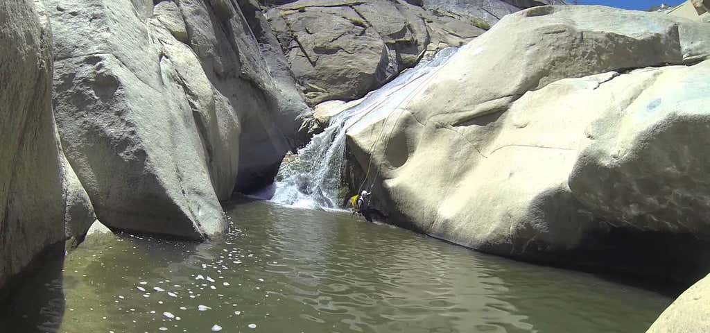
For those that have a 4WD vehicle, it may be possible to bypass crossing the Kern river completely. There is a gate at the start of the 2WD route marked on the map that is sometimes closed. When it is open, this might be the only option to run 7 Teacups when the Kern is flowing 3000cfs or higher. Usually it is possible to reach the Dry Meadow Primitive Campground area with a passenger vehicle, but high clearance 4WD (or hiking) is required for the rest of the approach. The last mile is especially rough. The gate is probably open between Memorial Day and Labor Day. Outside of that range, it is typically closed. Descent Walk, wade, swim and rappel down the water course. Jumps and slides are often appropriate, but always have one person check the depth first and that there are no hidden rock ledges. Swimming goggles are very useful, in their absence taking an underwater picture with a waterproof camera can also help discern possible dangers.
Some jumps are shallow but on sandy bottom, so should be safe to L-jump (jump with legs high and land on your butt). But other jumps are "technical", meaning you have to aim and a minor mistake may bring disastrous consequences. In general, if you jump make sure you land in the same spot of the person that jumped in front of you. If uncomfortable or not sure, just rappel.
First Pool: The canyon starts with a non-technical downclimb into a large pool, that is often used as a warm up jump. After that is a short swim/wade to the start of the "Seven Teacups".
Teacup 1: The first teacup is easily accessed by a short slide down or with a short jump from the edge. This teacup is split into two by an arch in the middle, which is often used as anchor and may or may not have a webbing around it. (It is good practice not to leave behind any webbing on this arch, which is easily achieved through a retrievable anchor.) The arch is also a checkpoint for the water levels; when the arch hole is completely submerged, the canyon is in high water conditions.
Teacup 2: You can rig the rope around the arch to rappel into the second teacup, L-jump into the sandy bottom, or slide the waterfall located on canyon right. This is perhaps the easiest non-trivial jump in the canyon.
Teacup 3: In recent years bolt anchors have been installed LDC at the bottom lip of teacup2, which makes for an easy rappel into teacup3 and saves from having to extend the rappel from the arch in teacup1. However, these bolts may get destroyed or disappear after years of heavy flow, so make sure the anchor is still there before you pull down from the arch. A crack on the LDC wall also provides an excellent knot chock placement. You may also jump into the third teacup, but please note this involves a technical jump into the deep area of the pool located on canyon left, which has hidden underwater rock ledges. A safer option is to slide down the waterfall in the middle of the pool.
Teacup 4: All the water of the river goes through a constriction at the lower lip of teacup3 that produces a forceful waterfall that engulfs the rappel. Bolts above the lip on canyon right provide for a fun wet rappel, but in high water conditions this is the most dangerous spot in the canyon, one where canyoneers risk being swept over the edge before they can even reach the anchors. Currents here can be so strong that sweep rappellers off their feet, invert them and trap them under the flow. Therefore is imperative to use a contingency anchor (such as a Figure 8 block) and man the station being ready to cut the rope in case of emergency. Guided rappels may not work well here, due to the lack of a strong anchor downstream. To jump is a valid option, but the depth of the pool below varies dramatically, some spots are over the head while others are just knee deep, and they change seasonally, so always send a person down to check for depth before anyone jumps. Once in teacup4, the edge of the pool may prove inescapable but it is possible to get out by carefully climbing out the edge of the next waterfall (at the end of a short corridor with two small potholes). Some choose to climb up on canyon left to the LDC lip of teacup4 (inaccessible from teacup3) to do an optional 20'+ jump into teacup4.
Teacup 5, Teacup 6 and Teacup 7: These teacups can be down climbed on canyon right, that albeit quite steep is not too hard. They can also be jumped by climbing the edge of each waterfall and pushing off from the edge. Waterfalls tend to accumulate rocks and debris under the whitewater areas but are usually deepest in the center of the pool. Approach the edge of a waterfall only if determined to jump, as hesitating at the edge may cause you to slip and fall on rocky ledges with severe consequences.
Technical Section: After the teacups, 3 to 4 rappels will follow in quick succession. All of them have bolt anchors and do not present any special difficulty or dangers.
Left Turn: After a few rappels, the canyon will turn 90 degrees to the left after a big waterfall. This waterfall can be bypassed by down climbing a series of ledges on canyon left, but is more fun to rappel by using two bolts hidden inside a dry small pothole at the top of the drop. This will produce a dry rappel if staying canyon left or wet if staying on canyon right. The wet rappel can be dangerous in moderate to high levels water, so make sure you gauge the water level appropriately before you commit to the wet rappel. Wet or dry, you will land in a large pool with a long swim.
Toilet Bowl: At the end of the pool there is a waterfall that flows sideways into a pothole below with a small lip. It is possible to do a dry rappel from a tree on canyon right, but it is much more fun to rappel into the pothole from a couple of bolts on canyon left. Rappelling into the pothole can be extremely dangerous at high flow, and even at moderate flow the current produced by the waterfall may be strong enough to trap all but the strongest swimmers. For this reason, the first person down should have some flotation in their pack and be ready to brace it while awaiting assistance if unable to escape the pothole. Some people choose to jump rather than rappel, but this is a risky technical jump where a mistake may have extreme consequences due to the small size of the pool, rock ledges that protrude from all sides, and very limited visibility from the top. Alternately, downclimb canyon right for a jump directly into the bottom pool (bypassing toilet bowl). Escape from the bottom pool can present somewhat of a challenge.
Last Rappel: when the canyon turns sharply right you will have reached the last rappel. From an anchor on canyon right rappel as far right as possible along the walls of the canyon until you find a metal chain with a hook anchored in one small pothole along the wall. This will provide a redirection point to safely land into the narrow slot below. If you don't use this redirection you will have to negotiate your way through a very narrow slot with multiple hazardous hydraulics that cannot be seen until one is over the edge. If doing the canyon with novices it is best to station someone at the pothole with the hook to assist people going through the redirection.
Read more: http://ropewiki.com/Seven_Teacups
Be the first to add a review to the Seven Teacups.
/-118.4871718,35.9935388,14/300x172@2x?access_token=pk.eyJ1Ijoicm9hZHRyaXBwZXJzIiwiYSI6ImNsdjQ5N2VtZDA2bW8ycW13ZHAxeGhjbjkifQ.UIccpoAxc7g3BAuK4s9vjg)
Seven Teacups
Hours
Problem with this listing? Let us know.
Has RV parking changed? Let us know.
-
Parking
-
Pets Allowed
-
Restrooms
-
Wifi
-
Wheelchair Accessible
-
Credit Cards Accepted
Parking
Nearby Hotels
Related Trip Guides
- Trip Guide
Pay Tribute and Reflect at These US Monuments and Memorials
- 14 Places
- Trip Guide
The Ultimate Guide To Joshua Tree National Park
- 53 Places
- 11:44
- 408 mi
- Trip Guide
The top things to do on an I-40 road trip
- 35 Places
- 49:44
- 2,851 mi
- Trip Guide
The top things to do on an I-10 road trip
- 55 Places
- 56:13
- 3,026 mi