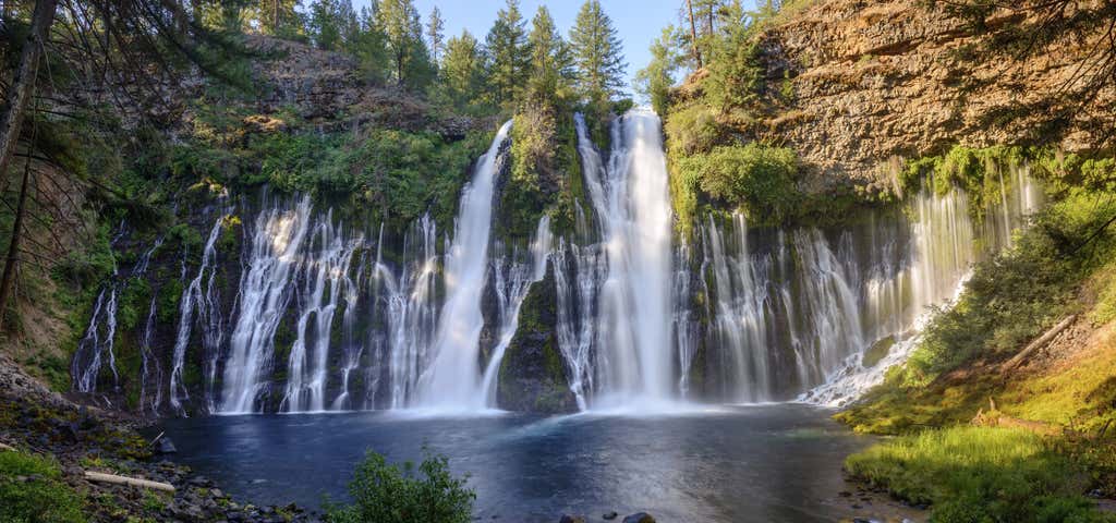
“100 million gallons of water rush over the falls every day”
The park is within the Cascade Range and Modoc Plateau natural region, with forest and five miles of streamside and lake shoreline, including a portion of Lake Britton. The park's centerpiece is the 129-foot Burney Falls, which is not the highest or largest waterfall in the state, but possibly the most beautiful. Additional water comes from springs, joining to create a mist-filled basin. Burney Creek originates from the park's underground springs and flows to Lake Britton, getting larger along the way to the majestic falls. The park's landscape was created by volcanic activity as well as erosion from weather and streams. This volcanic region is surrounded by mountain peaks and is covered by black volcanic rock, or basalt. Created over a million years ago, the layered, porous basalt retains rainwater and snow melt, which forms a large underground reservoir. Within the park, the water emerges as springs at and above Burney Falls, where it flows at 100 million gallons every day. Burney Falls was named after pioneer settler Samuel Burney who lived in the area in the 1850s. The McArthurs were pioneer settlers who arrived in the late 1800s. Descendants were responsible for saving the waterfall and nearby land from development. They bought the property and gave it to the state as a gift in the 1920s.
Reviews of McArthur-Burney Falls Memorial State Park
13 people have reviewed this location
Ratings Summary
Cell Coverage
Verizon 5G
Confirmed by 2 users | Last reported on June 02, 2023AT&T 4G
Confirmed by 1 users | Last reported on June 25, 2017T-Mobile 4G
Confirmed by 1 users | Last reported on April 01, 2021Reviews

We were only able to stay 1 night here but I enjoyed it very much. The falls are really spectacular. There is no Verizon service here.
We stayed in a "pull thru", I think it was number 11. While technically a pull thru you really needed to back in to use the spot. Not that big of a deal for us but know that going into it. There are also some tight corners to get to some of the sites.
The sites had water but no other utilities. The nearby bathrooms were well maintained. The sites were beautiful and spread out really nicely.
I was happy here.
Nightly Rate: $35.00
Days Stayed: 1
Site Number: -
RV Length: 25 ft
The falls and the hikes around this area are fantastic, there were few people around and very quiet. In typical Cali fashion it is very expensive for only water hookup. Bathrooms were decent and showers were available.
Nightly Rate: $35.00
Days Stayed: 1
Site Number: -
RV Length: 22 ft
Burney Falls is a great place to camp with tons to do nearby. We camp here every other year and are always excited to do
Campground details- This is a typical state park campground. There are large pine trees that create good shade at most sites.There are two loops of sites, rim and pioneer. I prefer the rim sites although they are older. All sites have a fire ring and some also have really neat stoves that were built when the park was originally built. There are no hook ups at regular sites but the handicap access sites do have electrical. There are two dump stations. Camp bathrooms are relatively clean. Showers are a quarter a minute and are very clean.
The campsite fills up early and can be crowded with families, kids ridding bikes and young people out having a good time but for the most part people are respectful of quiet hours and a their neighbors. We always meet great people at Burney.
Some sites to consider- 57, 60, 42. try not to be too close to the bathrooms.
One other note, the yellow jackets are really really aggressive, bring traps for your site and consider eating dinner after dark.
Things to do- this is what makes Burney so special! There is a lot to do. There are several nice hiking trails right in the campground. My favorite is the cemetery trail which takes you past a old over grown cemetery and down to the lake. We enjoy bringing suits, books and snacks and finding a quiet swimming hole along Lake Brittons edge.
The waterfall loop is also lovely. I encourage you to start at the top and cross over the bridge above the waterfall and then go down from there. Most people go the reverse way but this saves the waterfall for the end. you can swim down by the waterfall but knowi ti s very cold. Afterward stop by the camp store and grab an ice cream or beer.
There is a lot to do on lake britton, you can rent boats, skidoos, kayaks or canoes. The ranger leads a free canoe trip which was awesome. Make sure you sign up early in the visitors center. While you're there watch the history of Burney video which is really interesting. There is also fishing for trout, blue gill and perch
There is a lot to see outside the park as well, fish on hat creek, visit the subway cave- an underground cave formed by lava flows or head to Lassen national park which has great hiking and lovely views.
Burney is a small town outside the park. There are a few restaurants, gas stations and a laundry mat. There is free wifi at the mcdonalds which came in ahndy since there is no reception or wifi in the park.
I think Burney is by far one of the gems in the california state park system!
Nightly Rate: $35.00
Days Stayed: 7
Site Number: 57
RV Length: 27 ft
RV Type: Travel Trailer
Temps in the mid-90s probably didn't help, but we were definitely not impressed with this California State Park, especially at $35 night without hookups. The yellow jackets caused a buzz and the campsite was littered. When checking in we were told how busy the park has been and that a site just opened up. The park employee wasn't certain which way to direct us to pull into our site at the correct angle. With a 50-50 chance, we blew it and circled back around. After settling into our site, you could fire a cannon through the campground and not hit a soul. The park has potential with the falls and lake but we will not return.
We found the walk to Britton Lake pleasant and the restrooms were updated and clean. No cell service available.
Nightly Rate: $35.00
Days Stayed: 1
Site Number: 17
RV Length: 30 ft
RV Type: Travel Trailer
This campground is kind of an expensive disorganized free-for-all. We checked in early and I'm glad we did. The entry station area is a confusing mess with the store, day-use parking etc all in the same place. There is only one lane for entry so be prepared to wait. The kiosk attendant was very nice but we were asked to pull forward with our 50' truck and trailer, park in a two car parking space and walk back to register. What!? One car parked in the space, so had to park in the visitor center and block traffic.
Getting to the campground from the kiosk was a trip. We followed the kiosk attendants directions to the site, but couldn't back in from that direction, so had to drive around and do a u-turn at the dump station. Once we did this it was a fairly easy back-in. The campground is huge and not clearly marked for directions. Even when walking around the campground we were often wondering were the heck we were.
Our site was one of the nicest spots in the camp in my opinion. Very private. It was a huge site on the rim and we had nice sunsets. Dirt parking but plenty of room for the truck and trailer.Upon arrival the prior occupant left a bunch of trash and a pile of firewood lumber full of nails. I went through and cleaned the place up.
Bugs were terrible and the yellow jacket queens were looking for places to build nests. Mosquitoes and biting flies were prevalent. No hook ups but bathrooms had flush toilets. There were also showers available. The campground overall was very crowded and there were people and children everywhere. Most were very friendly and we enjoyed talking with some of them. I'm glad we picked the site we did since it was so large and away from the mosh pit of campers.
The falls were spectacular as was Burney Creek. Took a nice 2 mile hike around the falls and it was so cool a refeshing even though it was fairly hot. We took the dogs to the other side of adjacent Lake Britton to go swimming at a National Forest access instead of the State Park and it was nice. California State Parks are not dog friendly.
I would defintely come back here to see the falls on a day trip but doubt I would camp here again.
Nightly Rate: $45.00
Days Stayed: 2
Site Number: 41
RV Length: 30 ft
RV Type: Travel Trailer
Cell Coverage Rating
AT&T 4G

It had been over 20 years since the last time we camped here so I was pleased to see that updates had been made and the park is well maintained. Two loops: Rim Camp and Pioneer camp. Pioneer has over 20 cabins plus over 20 camping sites. We stayed in the Rim Camp; on a Monday the week before Memorial Day, we had our pick of sites as the park was nearly empty but the website warns that on weekends and during the summer, this park does fill up. No hookups so the $35 per night ($33 for seniors) price is a little pricey. Some sites have paved pads and some are dirt; since it rained hard as soon as we set up, we appreciated the pavement. Bathrooms have been updated since the last time we were here in the mid-1990s and they are individual rooms with toilet and sink and (powdered) soap but no trash receptacle. Didn’t check the condition of the showers. The two draws are Burney Falls and Lake Britton. We didn’t go to the lake because it was cold and rainy but there are boat and kayak rentals available, which we would take advantage of during nicer weather. Absolutely no cell service!
Nightly Rate: $33.00
Days Stayed: 1
Site Number: 24
RV Type: Van
Cell Coverage Rating
Verizon
“Due to the recent visitation surges at McArthur Burney Falls Memorial State Park, camping has been temporarily closed again, effective July 22, 2020, until further notice.”
from Parks.CA.gov
Beautiful campground and falls. Lots of trails. The noise from 89 was loud with all the logging trucks. Currently only a few campsites open but off season no one was there.
Nightly Rate: $30.00
Days Stayed: 1
Site Number: 12
Cell Coverage Rating
T-Mobile 4G

This was the second time I visited Burney Falls but my family has raved about it for years and years. I see why! Burney is awesome. This park features a gorgeous waterfall (as good as some in Yosemite), a big lake, fun activities and a well maintained campground. Activities I enjoyed include running the trails, hiking the trails, paddle boarding, boating and hiking up to hidden waterfalls from the other side of the lake.
The campground is really nice. It meanders through the trees from the falls to the lake. There's a mix of campsites for vehicles and tents plus cabins. I've stayed in sites with the cabins only. The sites are nice and big where additional tents and vehicles can accommodate additional guests. The cabins are simple: four walls, a roof, windows and bunks. No electricity nor heat. Cabins are clean as are the bathrooms and showers. Clean potable water is available near each site. There's a great general store stocked with food, ice, drinks, souvenirs and even ice cream for the kids.
The cabins are located near the road which can be noisy. Logging is big industry near Burney so trucks drive fast on the road day and night. On weekends the road noise is less. If staying in a cabin expect to hear trucks driving at 55 many times during the night. Bring ear plugs.
Almost zero cell service in the entire park (falls, lake, campground). There is wifi near some picnic tables at the enterance.
Nightly Rate: $100.00
Days Stayed: 2
Site Number: 63
RV Type: Van
Rv sites have no hookups but there is an online baited dump station. Site 91 is an rv site but really tough to park in. No cell service in the park but Wi-Fi is available at the visitor center for free.
Nightly Rate: $33.00
Days Stayed: 5
Site Number: 91
Cell Coverage Rating
Verizon
Be the first to add a review to the McArthur-Burney Falls Memorial State Park.
/-121.64911995759,41.012893937621,14/300x172@2x?access_token=pk.eyJ1Ijoicm9hZHRyaXBwZXJzIiwiYSI6ImNsdjQ5N2VtZDA2bW8ycW13ZHAxeGhjbjkifQ.UIccpoAxc7g3BAuK4s9vjg)
McArthur-Burney Falls Memorial State Park
Hours
- Sun - Sat: 7:00 am - 6:00 pm
Problem with this listing? Let us know.
Has RV parking changed? Let us know.
-
Parking
-
Pets Allowed
-
Restrooms
-
Wifi
-
Wheelchair Accessible
-
Credit Cards Accepted
- Max Stay
- 14
- Max Length
- 32 ft
- Affiliation
- State park or forest
- Sites Count
- 104
- Last Nightly Rate
- 35.0
- Lowest Nightly Rate
- 30.0
- Standard Tent Sites Count
- 30
- Longest Vehicle Length Reported
- 30 ft
-
Sites
-
Laundry
-
Propane
-
Showers
-
Big Rigs
-
Boondock
-
Firewood
-
Tent Sites
-
Cabin Sites
-
Full Hookup
-
Dump Station
-
Mobile Homes
-
Public Water
-
Pull Through
-
Reservations
-
Sewer Hookup
-
Water Hookup
-
Potable Water
-
Age Restricted
-
Rec Facilities
-
Dispersed Sites
-
Open Seasonally
-
Permit Required
-
Group Tent Sites
-
Fulltime Residents
-
Standard Tent Sites
-
Pull Through RV Sites
Campground, Restrooms
Nearby Hotels
Related Trip Guides
- Trip Guide
Pay Tribute and Reflect at These US Monuments and Memorials
- 14 Places
- Trip Guide
The Ultimate Guide To Joshua Tree National Park
- 53 Places
- 11:44
- 408 mi
- Trip Guide
The top things to do on an I-40 road trip
- 35 Places
- 49:44
- 2,851 mi
- Trip Guide
The top things to do on an I-10 road trip
- 55 Places
- 56:13
- 3,026 mi