“winds through pine forests, lava flows and riparian zones”
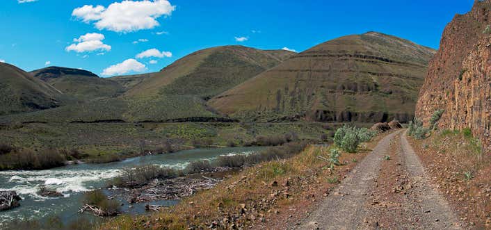
A series of three parallel trails through pine forests and lava flows along the variously placid and tumultuous Deschutes River. Separate trails were built for hikers, horses, and bicycles. Cyclists also share the hiking trail nearest the river, as long as conflicts are minimized. Low snow years can allow year-round use for most of this trail. Due to heavy use and repeated conflicts, dogs must be on a leash on these trails. Mountain Bike Description: Ride back on FS 700 and turn left onto FS 4120, riding towards the river. Continue down FS 4120 for a short time until you reach the overflow parking lot and gated road. Pass through the gate and ride along this road for 0.75 mile. Just before you reach a second gate turn left onto a single track. Cross the road at the Big Eddy Rapids parking lot and continue along this trail for 0.75 mile as you cross several abandoned roads and alternate between single track and double track. When you rejoin FS 4120, at a third gate, follow this for 1 mile as it overlooks the river. Just past the forth gate turn left toward Dillon Falls. At the end of the Dillon Falls parking lot follow the single track back to FS 4120 to retrace your route back to Lava Island Falls and the trailhead. This route follows Forest service's recommended mountain bike route along the Deschutes River between Lava Island Falls and Dillon Falls. Mountain bikers are urged to use this route along this congested corridor to reduce user conflicts between mountain bikers, hikers and horse travelers. Directions from Bend: Trail is reached from several trailheads off Forest Rd. 41, including Meadow, Lava Island, Big Eddy, Aspen, Dillon, Slough Camp, and Benham West Trailheads. Road 41 turns south off Century Drive, 7 miles west of Bend. Access also from the Benham Falls Picnic Area at the end of Forest Rd. 9702 just west from Lava Lands Visitor Center (located on Hwy. 97 between Sunriver and Bend). Northwest Forest Pass required.

A series of three parallel trails through pine forests and lava flows along the variously placid and tumultuous Deschutes River. Separate trails were built for hikers, horses, and bicycles. Cyclists also share the hiking trail nearest the river, as long as conflicts are minimized. Low snow years can allow year-round use for most of this trail. Due to heavy use and repeated conflicts, dogs must be on a leash on these trails. Mountain Bike Description: Ride back on FS 700 and turn left onto FS 4120, riding towards the river. Continue down FS 4120 for a short time until you reach the overflow parking lot and gated road. Pass through the gate and ride along this road for 0.75 mile. Just before you reach a second gate turn left onto a single track. Cross the road at the Big Eddy Rapids parking lot and continue along this trail for 0.75 mile as you cross several abandoned roads and alternate between single track and double track. When you rejoin FS 4120, at a third gate, follow this for 1 mile as it overlooks the river. Just past the forth gate turn left toward Dillon Falls. At the end of the Dillon Falls parking lot follow the single track back to FS 4120 to retrace your route back to Lava Island Falls and the trailhead. This route follows Forest service's recommended mountain bike route along the Deschutes River between Lava Island Falls and Dillon Falls. Mountain bikers are urged to use this route along this congested corridor to reduce user conflicts between mountain bikers, hikers and horse travelers.
Be the first to add a review to the Deschutes River Trail.
/-121.3783417,44.0005472,14/300x172@2x?access_token=pk.eyJ1Ijoicm9hZHRyaXBwZXJzIiwiYSI6ImNsdjQ5N2VtZDA2bW8ycW13ZHAxeGhjbjkifQ.UIccpoAxc7g3BAuK4s9vjg)
Deschutes River Trail
Hours
Problem with this listing? Let us know.
Has RV parking changed? Let us know.
-
Parking
-
Pets Allowed
-
Restrooms
-
Wifi
-
Wheelchair Accessible
-
Credit Cards Accepted
Nearby Hotels
Related Trip Guides
- Trip Guide
A road trip to filming locations featured in 'The Goonies'
- 6 Places
- 00:57
- 28 mi
- Trip Guide
The Ultimate Guide to Crater Lake National Park
- 15 Places
- Trip Guide
- Weekend
Pacific Coast Highway: Oregon - Washington
- 30 Places
- 17:36
- 670 mi
- Trip Guide
The top things to do on a U.S. Route 20 road trip
- 23 Places
- 60:25
- 3,576 mi