

Written by Malee Oot
Not so long ago, West Virginia’s Monongahela National Forest was a collage of denuded mountains and barren agricultural land, ravaged by timber and mining operations. But, when a ferocious flood inundated the city of Pittsburgh in the spring 1907, officials started paying attention to the overharvested highlands of West Virginia, the source of six of the region’s major river systems. To preserve vital watersheds—and to prevent catastrophic flooding—the U.S. government began purchasing parcels of land in the Mountain State. By 1920, the federal government had cobbled together 54,000 acres in West Virginia, which were then designated as the Monongahela National Forest.
Over the last century, the national forest has expanded to more than 919,000 acres, including 115,000 acres of federally designated wilderness, spread out over 10 different counties. Lovingly referred to as “The Mon,” today the fourth largest national forest east of the Mississippi River is a wonderland for outdoor enthusiasts with world-class whitewater, secluded trout streams, under-the-radar campgrounds, and more than 800 miles of hiking trails.

Soaring above the North Fork of the Potomac River’s South Branch, the 900-foot Tuscarora quartzite formation known as Seneca Rocks is an exceptionally photogenic natural landmark sculpted by more than 440 years of geological processes. The formation’s interior pinnacle, known as the Gendarme, toppled in 1987, and today, the crag includes both a north and a south peak. The first recorded ascents of the vertiginous crag began in the 1930s, although a climbing party that scaled the massif in 1939 discovered an inscription dated 1908. From 1943 to 1944, the Army used the hulking quartzite formation to train soldiers for alpine combat in Italy’s rugged Apennine Mountains, teaching climbing techniques on Seneca Rocks and other regional rock spires.
Today, the towering formation is still a hub for East Coast climbers, with more than 330 mapped routes. However, non-climbers can take in the views along the 1.3-mile Seneca Rocks Hiking Trail, which tops out at an observation platform at the edge of the North Peak. For an overnight getaway, the Seneca Shadows Campground (a little more than a mile away on Route 28) offers superb views, especially at sunrise and sunset.

2
Smoke Hole Canyon
Smoke Hole Canyon is a rugged slice of wilderness cradled by the Cave and North Fork mountains. Threaded by the South Fork of the Potomac River, the precipitous gorge offers wild expanses still untouched by roads or trails, accessible only on the water. According to local lore, there are two theories behind the canyon’s evocative name: one suggests that the cave-pocked canyon was used by Native Americans to smoke meat. Another suggests that the moniker comes from smoldering stills stashed away in the region’s rugged riverside bluffs by industrious moonshiners.
Either way, the gorge is a haven for anglers, hikers, and backpackers. The canyon’s waterways are stocked with rainbow and golden trout and the 24-mile North Fork Mountain Trail skirts the gorge’s western edge. For an overnight getaway, the Big Bend Campground offers campsites spread along a horseshoe curve in the South Branch of the Potomac River.

The Bear Rocks Preserve protects a biologically-rich, 477-acre expanse of high-elevation cranberry bogs, heath barrens, and jumbled boulders perched at the eastern edge of the Dolly Sods plateau. Part of a landscape scarred by extensive logging and livestock grazing—and used as an artillery range by the military during World War II—the swath of land was acquired by The Nature Conservancy in 2000, and expanded with the acquisition of the 1,143-acre Allegheny Front Preserve in 2018.
In early 2021, the two preserves were combined into the country’s 600th National Natural Landmark. For hikers, views from the Bear Rocks Preserve’s boulder-hewn escarpment extend all the way to the Blue Ridge Mountains in Virginia. The unmarked trail network provides chances to see pint-sized saw-whet owls, Cheat Mountain salamanders, and songbirds migrating along the Eastern Appalachian Flyway.

"Street view in Davis, West Virginia" — Photo Credit: Malee Oot
Spread along the Blackwater River at the northern edge of the Monongahela National Forest, the town of Davis sprang up in the late 1800s. Catalyzed by the region’s extractive industries—logging, mining, and fur trapping—the town’s population burgeoned in the early 1900s after the arrival of the West Virginia Central and Pittsburg Railway. The natural resources in the region were overtaxed by the 1920s, and local industries began to decline, but, by the early 1980s, the town’s proximity to the national forest began luring mountain bikers seeking rugged stretches of singletrack. The region started playing host to some of the East Coast’s most grueling races, including the Blackwater 100 (known as one of the “toughest races in America,” it ran until 1993).
These days, the town still visibly caters to outdoor lovers as a basecamp providing easy access to Blackwater Falls, Canaan Valley State Park, and the Dolly Sods Wilderness, a 17,371-acre slice of the Monongahela National Forest. For visiting cyclists, Blackwater Bikes offers bike rentals and shuttles, and has a full repair shop for emergencies.
Davis, West Virginia, United States

6
Highland Scenic Highway
A celestial stretch of roadway between Marlinton and Richwood, the Highland Scenic Highway treats travelers to unsurpassed views of the Allegheny Highlands, and serves as a portal to an abundance of outdoor offerings. Cobbled together from Route 150 and Route 39/55, the 43-mile scenic route tops out on Black Mountain at more than 4,550 feet. Highlights along the highway include the 47,815-acre Cranberry Wilderness, a former black bear sanctuary laced with trails and trout streams, and the Cranberry Glades Botanical Area, a 750-acre National Natural Landmark preserving sphagnum bogs, ruffed grouse, and carnivorous pitcher plants.
The panoramic byway is dotted with four scenic overlooks, perfect for picnicking and snapping photos. For multi-day adventures, a handful of campgrounds are spread along the highway: Near Richwood, the Summit Lake Campground features wooded sites with access to a 43-acre lake; and the Day Run and Tea Creek campgrounds are ideal for anglers pursuing seasonally stocked trout on the Williams River (camping is also permitted at primitive sites along the river).


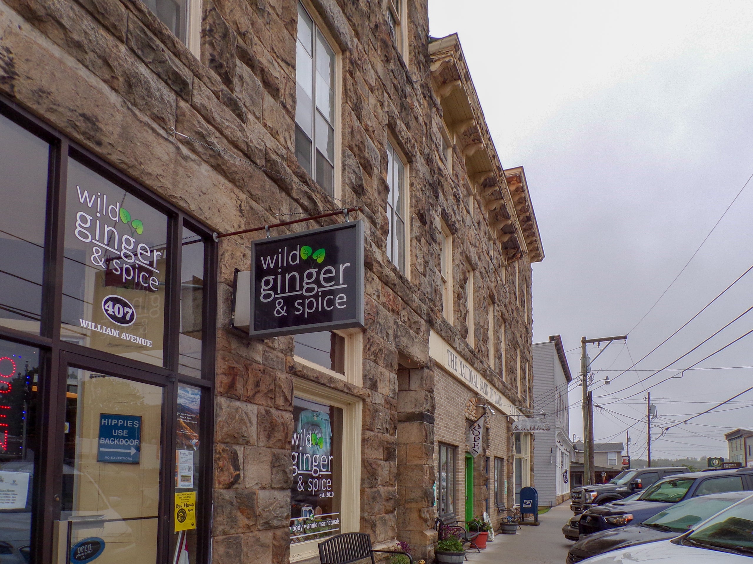
"Marlinton, West Virginia" — Photo Credit: Malee Oot
Named for Jacob Marlin, who arrived in the region in 1749, the town of Marlinton mushroomed with the arrival of the Greenbrier Division of the Chesapeake and Ohio Railroad in the early 1900s. Today, there are still plenty of reminders of the whistle-stop town’s early 20th-century heyday. Built in 1910, the Pocahontas County Opera House was salvaged by the Pocahontas County Historic Landmarks Commission in 1991, after temporarily being repurposed as a storehouse for lumber and used cars. The 250-seat venue hosts performances year round. Another long-standing staple in Marlinton is the Pocahontas Times. First published in 1882, the newspaper was still using handset type in the early 1980s, when a catastrophic flood ravaged the region and forced the publication to rapidly digitalize. In addition to the abundance of historic architecture, the town of Marlinton also hosts an annual Autumn Harvest Festival and Roadkill Cook-Off, a gastronomic mainstay for more than two decades.
Marlinton, West Virginia, United States

9
Greenbrier River Rail Trail State Park
Paralleling the Greenbrier River for 78 miles, from Caldwell to the Cass Scenic Railroad State Park, the Greenbrier River Trail is a microcosm of West Virginia’s history. The multi-use trail traces the former route of the Greenbrier Division of the Chesapeake and Ohio Railway, a freight and passenger line first operational in the early 1900s, catering primarily to the Greenbrier Valley’s timber industry. However, by the 1970s, freight loads on the line had diminished significantly, and in 1979, the tracks were removed and the historic thoroughfare was donated to the state.
Reimagined as a rail-trail (the longest in West Virginia) for hikers, cyclists, cross-country skiers, and equestrians, the gently graded crushed gravel pathway rambles over 35 bridges, stringing together state parks, historic towns, and forests. For multi-day excursions, there are 15 different camping areas scattered along the trail, rentable cabins in Watoga State Park and the Seneca State Forest, and inns and bed and breakfasts in Burnsides, Caldwell, Marlinton, and Seebert.

10
Cass Scenic Railroad State Park
Providing a firsthand glimpse of the region’s rich railroading history, Cass Scenic Railroad State Park preserves a stretch of railroad. Completed in 1901 to serve the West Virginia Pulp and Paper Company—and operational for more than a half century—the rail line was used until 1960 when the Cass mill shuttered for good. Just a year later, the historic company town and rail line became a part of West Virginia’s state park system. Today, the park features an extensive collection of historic Shay locomotives, and offers scenic train rides along the forested slopes of the 4,842-foot Bald Knob.

11
National Radio Astronomy Observatory's Green Bank Telescope
Just outside the town of Green Bank, along Route 28 (the Potomac Highland Trail), an unexpected sight rises from the leafy canopy of the Monongahela National Forest: the massive Robert C. Byrd Green Bank Telescope. The largest steerable telescope on the planet, the 17 million-pound telescope is part of the Green Bank Observatory. A hub for radio astronomy research since the 1950s, the observatory is used to study galactic wonders such as black holes and gas clouds—and to search the cosmos for signs of intelligent life.
To protect the observatory’s highly sensitive equipment, along with technology housed at Naval facilities in Sugar Grove, the Federal Communications Commission established a 13,000-acre National Radio Quiet Zone in the region in 1958. The designation also means the use of electronic equipment—such as microwaves and WiFi routers—is banned within a 2-mile radius of the facility, including in the town of Green Bank. While smartphones must be turned off, visitors can tour the observatory along an extensive network of walking trails, and delve into the facility’s past and present research initiatives at the Green Bank Science Center.

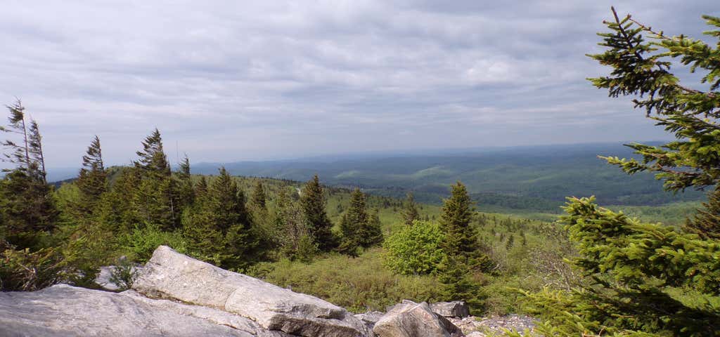
The 4,863-foot Spruce Knob is the highest point in West Virginia. The pinnacle offers impressive views of the Mountain State, stretching from Spruce Knob Lake and the Middle Mountain range in the west to North Fork Mountain in the east. For a short summit tour, the 0.7-mile Whispering Spruce Trail provides a panoramic loop that offers access to the peak’s stone observation tour and weaves through shadowy spruce forests carpeted with spongy clusters of moss and liverwort.
For a longer trek, the 5.8-mile Huckleberry Trail also departs from the summit area, and the adjacent Spruce Knob-Seneca Creek Backcountry area is threaded with more than 60 miles of trails for hikers and backpackers. About a 20-minute drive from the summit, the Spruce Knob Lake Campground offers secluded campsites nestled into the forest.
Banner Photo Credit: Malee Oot
Roadtrippers
Roadtrippers helps you find the most epic destinations and detours—from roadside attractions to natural wonders and beyond.
Explore More Trip Guides
- Trip Guide
A Highway 1 road trip along California’s Central Coast
- 14 Places
- 02:49
- 99 mi
- Trip Guide
Route 66 Leg 2: St. Louis to Tulsa
- 61 Places
- 18:31
- 876 mi
- Trip Guide
Route 66 Leg 1: Chicago to St. Louis
- 71 Places
- 16:31
- 636 mi
- Trip Guide
Route 66 Leg 3: Tulsa to Amarillo
- 94 Places
- 18:36
- 867 mi