
7088 Red Mesa Drive, Littleton, Colorado, United States

“Dino footprints everywhere!” This 1.5-mile trail along Alameda Parkway, between Rooney Road North and County Road 93, has hundreds of dinosaur tracks, a quarry of dinosaur bones, and interesting geologic features. To hike the Ridge will take between 1-2 hours and is about 2 miles round trip. Originally uncovered accidently during the construction of West Alameda Parkway in 1937, the large tracksite was open for 52 years until the Friends of Dinosaur Ridge was formed to aid in preservation and protection of the footprints. Many tracks were vandalized or completely removed, though a single track found its way back in 2007 (this track and its story can be seen in the Trek Through Time exhibit). Today, after an expansion of the main site in 1994, over 300 tracks have been identified. Of those at least half are periodically colored using charcoal by Dinosaur Ridge volunteers to help visitors see the tracks in the sandstone.

The beauty of the rugged Rocky Mountains surrounds you as our old-time steam locomotive or one of our powerful diesel locomotives winds up the Clear Creek canyon. Pass by remains of gold and silver mines and breathtaking views along the line, in fully enclosed and open cars. Great family fun for kids of all ages.
Coach cars are cars with bench seating. They are open-air cars in the spring, summer, and fall, then enclosed and heated during the winter months.
Parlor cars are fully enclosed, carpeted, with table and chair seating. Guests receive some lite snacks and a non-alcoholic beverage. Beer and wine are available for purchase. Depart Devil's Gate or Silver Plum stations. 3 or 4 departure times/day. about $25/
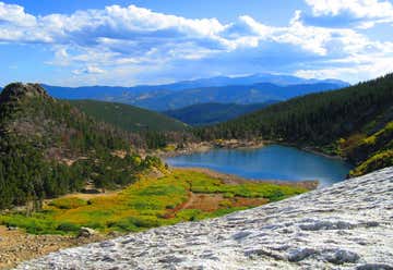
Located just north of the ghost town Alice, this popular, 1.5-mile out-and-back in Colorado's Front Range follows dirt roads and rocky trails up to the snowy slopes of St. Marys Glacier. Plan 2 hours round trip. Start at the pay parking area next to Fall River Road and walk southwest to reach the trailhead. The first 0.3 mile climbs up undeveloped roads before turning onto a rocky trail that leads to the banks of St. Marys Lake. Half a mile in, cross a small bridge over the lake's outlet creek and continue north, passing up-close views of Fox Mountain to the east (look for yellow-bellied marmots in the surrounding rocks and meadow). After 0.7 mile, the trail reaches the base of St. Marys Glacier. Climb another 100 yards up the glacier and take in views across the Silver Creek drainage. Follow the same route back to the trailhead. First is parking at the St. Mary’s Glacier Trailhead.
There are two parking lots for the trailhead (one south of the trailhead which is fairly large and one north of it that’s smaller) and both require you to pay a $5 fee and display a permit on your windshield. Permits are easily obtained from marked posts in both parking lots, but you’ll need to bring your own pen to write down your license plate number on the fee envelope. Restrooms in the parking lots are a giant bonus and seemed (today, at least) to be very well-maintained.
7088 Red Mesa Drive, Littleton, Colorado, United States
