

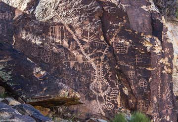
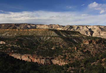
Approximately 15 million years ago, a long slender section of sedimentary rock sheared from the earth's crust along parallel fault lines. This up-thrown block, later named the Red Hills, began to inch its way above the surrounding valley floor. At the same time the block was rising, a stream was cutting a path perpendicularly across the ridge. For millions of years the uplifting of the ridge and the down-cutting of the stream remained in equilibrium. Eventually however, the relentless rise of the ridge and the drying of the region's climate combined forces to defeat the stream. The stream disappeared and the valley became a waterless wind gap. Continued erosion by wind and rain have shaped the gap into the pass seen today. Parowan Gap Petroglyphs Several centuries ago Native Americans traveling through the area stopped and pecked designs onto the smooth faces of large boulders found on the east side of the gap. Over the years many of the boulders have been covered with these chiseled figures known as petroglyphs. The petroglyphs here are thought to be the work of several cultural groups and represent a long period of use by Native cultures. What these designs mean is still unknown. Archaeologists debate that they represent concepts, ideas or actual happenings. Perhaps they were part of a religious activity or hunting ritual. The local Native Americans consider them to be an important part of their cultural history relating stories of their ancestor's lifeways. New dating techniques are being developed that will allow petroglyphs to be placed in time. While we don't know the precise age of these petroglyphs yet, we do know that the agriculturally based Sevier-Fremont lived in the area over a thousand years ago. There is little doubt that some of the designs were made by this group, or perhaps even the earlier nomadic Archaic peoples. Researchers believe that the semi-nomadic ancestors of the present day Southern Paiute also created some of these figures. The Parowan Gap Petroglyphs are listed on the National Register of Historic Places signifying its importance as a cultural treasure. When sites are damaged in any way, much of what they can tell us is lost forever. Please tread lightly, causing as little disturbance as possible. Rock art should be photographed or sketched but not touched in any way. Fingers and palms leave oils that speed deterioration. Chalking the figures will eliminate the chance to use new dating techniques in the future. Laws with stiff penalties have been enacted to protect our past. But each of us have a responsibility to help preserve this and other archaeological and historically significant sites. Please report any vandalism to the local BLM Office or Sheriff. Parowan Gap Parowan Gap has two features of distinction, one natural, one man-made. The pass near Parowan is a classic example of a wind gap, an unusual geological landform marking where an ancient river has cut a 600-foot-deep notch through the Red Hills. Secondly, the gap is a nationally recognized extravaganza of petroglyphs--a superb "gallery" of Native American rock art. Here one can witness what is at least a 1,000 year accumulation of artwork pecked into the rock. Geometric designs, images of lizards, snakes, mountain sheep, bear claws and human figures adorn the smooth canyon walls of the pass. These features, set amidst the vast panoramas of the Escalante Desert make for a fascinating getaway located just a few miles off the interstate mainstream.
Torrey, Utah, United States
Capitol Reef National Park is a United States National Park, in south-central Utah. It is 100 miles long but fairly narrow. The park, established in 1971, preserves 378 mi and is open all year, although May through September are the most popular months. Located in south-central Utah in the heart of red rock country, Capitol Reef National Park is a hidden treasure filled with cliffs, canyons, domes and bridges in the Waterpocket Fold, a geologic monocline (a wrinkle on the earth) extending almost 100 miles. The area of Capitol Reef has been a homeland to people for thousands of years. Archaic hunters and gatherers migrated through the canyons. Fremont Culture solidified around 500 CE, from food foraging groups, to farmers of corn, beans and squash. Petroglyphs etched in rock walls and painted pictographs remain as sacred remnants of the ancient Indians' saga. Explorers, Mormon pioneers and others arrived in the 1800s, settling in what is now the Fruita Rural Historic District. They planted and nurtured orchards of apples, pears, and peaches. The geology of the Waterpocket Fold created conditions which allowed unique plant species to evolve here. A total of 887 plant species occur in the park many of which have very restricted distributions, occuring on specific geologic formations, soils, slopes, or elevation or precipitation ranges.
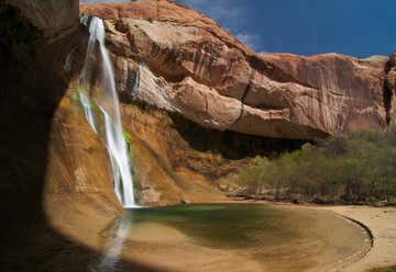
Calf Creek Falls is a southern Utah landmark and the major feature of the BLM's Calf Creek Recreation Area. Walking between mineral-streaked cliffs of Navajo Sandstone, hikers pass beaver ponds and pre-historic rock art sites enroute to the 126-foot-high Lower Calf Creek Falls.Roundtrip distance to the falls is 5-1/2 miles. While little elevation change is encountered, most of the trail is sandy, and can be very strenuous walking, particularly in warm weather. However, the falls area, once reached, is a delightfully cool, shady haven well worth the effort. The hike begins in the Calf Creek campground located on Hwy 12, 15 miles east of Escalante. Hikers are charged a day use fee of $2.00 per vehicle. The 6.0 mile round trip hike to the 126 foot lower falls is on a developed trail adjacent to Calf Creek. The hike is moderately difficult due to sandy sections. An interpretive brochure is available at the trailhead. The hike can be hot, especially during summer months, and hikers must carry adequate water. This is a good introductory hike to the Escalante Canyons. Dogs must be leashed.

The Hole-in-the-Rock Expedition In the autumn of 1879, some 250 men, women, and children undertook one of the most challenging and dramatic pioneering expeditions in American history. Their mission? To establish a settlement along the San Juan River in the southeast corner of Utah. Their plan? To blaze a direct transportation route through 200 miles of remote and breathtakingly rugged country that stretches southeast of Escalante. An expedition they expected to last six weeks became an epic six-month journey demanding scarcely imaginable endurance, determination, faith, and grit.
Taking a Shortcut Two circuitous routes to the San Juan River existed when the Hole-in-the-Rock expedition began. Lack of water and unpredictable relations with native people along those routes—along with a desire to reach their destination quickly—prompted mission leaders to forge a direct route.
Hole-in-the-Rock When the pioneers finally glimpsed the Colorado River it lay 1800 vertical feet below them. The wagon train camped for six cold and snowy weeks while men carved out the narrow, precipitous path to the river for which the expedition is now named.
Dance Hall Rock The Hole-in-the-Rock pioneers camped at Forty-miles Spring for more than three weeks, watiting for all expedition members to arrive and for leaders to determine if the proposed route was feasible. To pass the time, they held dances in a natural amphitheater they called Dance Hall Rock, now a National Historic Site.
Redrock Labyrinth After the Herculean effort of sagely maneuvering 83 wagons down to the Colorado River, the pioneers’ journey was far from over. Ahead of them lay two months of arduous travel through ore than 140 miles of canyon and rolling slickrock.
Escalante’s Role Three Escalante residents: Charles Hall, Andrew P. Schow, and Reuben Collett made the first scouting reports on the Hole-in-the-Rock route. Hall and his sons cut timber on the Aquarius Plateau for the ferry the expedition would use to ford the Colorado River, and many Escalante residents helped build the vessel. During the long journey, expedition members periodically returned to Escalante for supplies and mail.
Escalante Petrified Forest State Park is located at Wide Hollow Reservoir, a small reservoir that is popular for boating, canoeing, fishing and water sports. The park includes a developed campground with RV sites and a nice group area. There is also a pleasant picnic area. On the hill above the campground you can see large petrified logs. A marked hiking trail leads through the petrified forest.At the Visitor Center you can view displays of plant and marine fossils, petrified wood and fossilized dinosaur bones over 100 million years old.

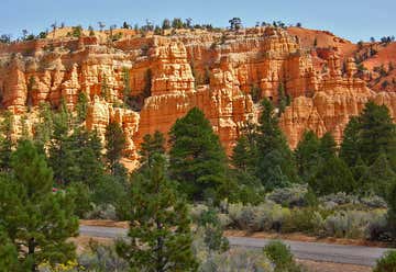
As part of Dixie National Forest, rather than a national park or monument, there are no entry fees to drive through or hike in Red Canyon. The Red Canyon Visitor Center was completed in the winter of 2004. It is located along Highway 12 and is open Memorial Day to Labor Day. Information is offered inside on hiking, ATV trails, 4WD trails, horse trails and the beautiful paved bike trail that runs through Red Canyon. There are some fun hikes in Red Canyon including the Birds Eye Trail. This is a moderate .8 mile hike that takes hikers up close to red rock formations. The 3 mile Losee Canyon Trail takes hikers past some select rock formations.
Banner Photo Credit: Santi + Mariela Torres (Roadtrippers)
