
Sea-Tac Airport Arrivals, Seattle, Washington, United States
18020 4th Avenue South, Seattle, Washington, United States
drive north on Hwy 101 for 35 miles and, one mile south of Amanda Park, turn east onto South Shore Road. Drive along Amanda Park for about 13.5 miles, then arrive at a junction at the Quinault River Bridge. Continue right, proceeding about six miles to the road's end and the trailhead.
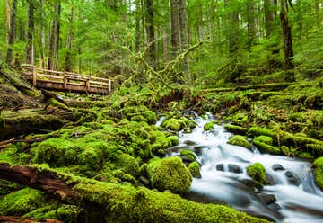
Begin at the Graves Creek Trailhead. At a signed junction, continue left on the wide, abandoned road through towering firs and cedar. Two miles in, the old road ends and you'll descend steeply through hemlock and fir to the East Fork Quinault. The Pony Bridge, at three miles crosses the river over a narrow, picturesque gorge lined with maidenhair ferns.
The trail continues over a series of ups and downs while paralleling the river.
Just past O’Neil Creek, at 6.7 miles, is O’Neil Creek Camp. The trail ahead crosses numerous streams including No Name Creek and Pyrites Creek, at 8 and 9.5 miles respectively. There are a few campsites near Pyrites Creek. Use caution when crossing Pyrites Creek.
The trail continues climbing to the Quinault River Bridge at 12.5 miles. Once across, the trail meanders into the charming Enchanted Valley at 13 miles.
In early summer, countless waterfalls stream down the sheer walls of valley. Bears are common in the valley area, so store your food properly at all times.
Highway 101, Forks, Washington, United States
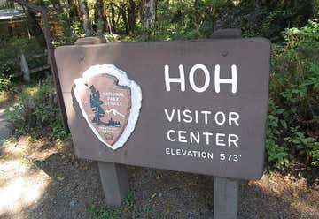
1a. Hall of Mosses: Distance: 1 miles RT / Trailhead: Hoh Rain Forest Visitor Center / Coordinates: 47.8536, -123.9512 Upper Hoh Road, which turns into Hoh Valley Road. Proceed to the trailhead, near the Hoh Rain Forest Visitor Center at the end of this road. 1b. SPRUCE NATURE TRAIL: Distance: 1.4 miles RT / Trailhead: Hoh Rain Forest Visitor Center / Coordinates: 47.8536, -123.9512
Lovers Lane Trail (option): (connects to sol duc falls) : 5.8 RT/ moderate/ Co-ordinates: 47.9622, -123.8499. SOL DUC FALLS TRAIL: 1.6 miles RT / Trailhead / Storm King Ranger Station. From Port Angeles, travel west on Hwy 101 for 29 miles to Sol Duc Road. Turn left and continue for 14 miles, passing the hot springs, to the parking lot at the end of the road.Coordinates: 47.9700, -123.8627
Olympic Hot Springs, Port Angeles, Washington, United States
Olympic Hot Springs: 4.8 mile RT / Olympic Hot Springs Road and follow this road until it ends at the Appleton Pass trailhead / Coordinates: 47.9775, -123.6925
150 East Front Street, Port Angeles, Washington, United States
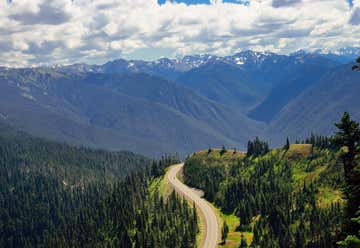
HURRICANE HILL: 3.2 miles RT / Hurricane Ridge Visitor’s Center From Port Angeles, turn off Highway 101 onto Race Street. Continue on Race Street for 1.2 miles to Hurricane Ridge Road. A large structure to your right is the Olympic National Park Visitors Center and Wilderness Information Center.Stop here to grab a map and a park pass, if you need one, then continue up the Hurricane Ridge Road for 18 miles to the Hurricane Ridge Visitors Center. Pass the Visitors Center and drive one and a half miles down the road to the trailhead parking area. Coordinates: 47.9766, -123.5178 https://www.wta.org/go-hiking/hikes/hurricane-hill
5230 16th Avenue Southwest, Seattle, Washington, United States

Sea-Tac Departures, Seattle, Washington, United States
