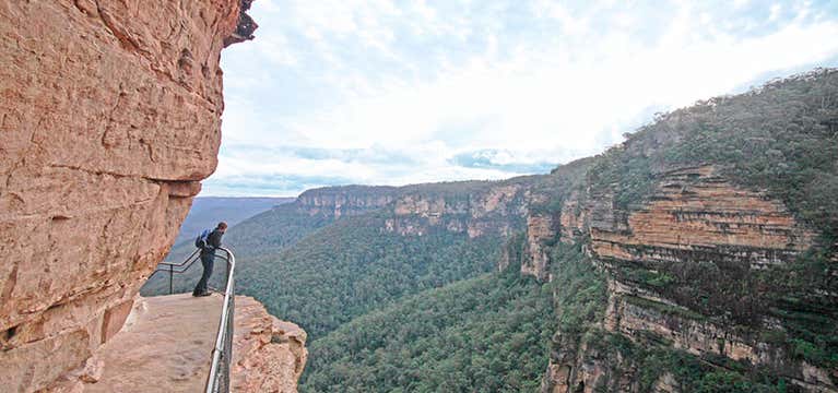


National Pass
Built into the side of a cliff, this walk captures spectacular views of the Jamison Valley, stunning waterfalls and a slice of the Blue Mountain’s pioneering history. The path begins at Wentworth Falls picnic area where you can get an almost birds-eye view into the valley below. As you head out onto the historic Grand Stairway, keep in mind this track was built by hand in the early 1900s. The men who built it used only picks, shovels and the odd stick of dynamite.
When you enter the Valley of the Waters, you’ll be greeted by some stunning waterfalls, including Empress, Silvia and Lodore Falls. Climb out of the valley to Conservation Hut when you’ll be rewarded with a hot cuppa.
We recommend filling out a free trip intention form (https://www.nationalparks.nsw.gov.au/safety/bushwalking-safety/trip-intention-form) before heading off on the National Pass. You should also check the weather before setting out as some sections of the track become impassable after rain.

Mt Warning summit trail
See as far north as Gold Coast and as far south as Byron Bay from the top of Mt Warning on this 8.8km, five hour return walk. Winding upwards from the Breakfast Creek parking area, the Mt Warning summit trail will take you through subtropical and temperate rainforests, forest and shrubland. Be warned - the section just before you reach the summit involves a steep rock climb. Once at the top, set up a picnic lunch and take your time to enjoy the stunning 360 degree views over sections of Queensland and New South Wales.
If you’re heading out in winter, make sure you do not proceed to the summit after 1pm. It can get dark early in the depths of winter which has led people to get lost on their way down the mountain.

Breadknife and Grand High Tops walk
Regarded as one of the best day walks in NSW, the Breadknife and Grand High Tops track is the best way to get up close to the volcanic beauty of the Warrumbungle National Park. You’ll get up close to the iconic rock formations of Belougery Spire, Bress Peak and Crate Bluff on the way and see one of the best panoramas in NSW from the Balor Hut campground. There’s also some fierce birdlife to keep an eye out for including wedge-tailed eagles and peregrine falcons.
The 14.5km track starts from Pincham carpark south of John Renshaw Parkway. To complete the full track, follow West Spirey track, back to Pincham carpark, after reaching Dows Camp. Alternatively, you can take a shorter 12.5km return via Dagda Shortcut.
Please note, entry fees apply to enter Warrumbungle National Park.

Abrahams Bosom Reserve
Take your pick from two scenic walks, or complete both in a day, at Abrahams Bosom Reserve. This reserve includes stunning beaches, a natural rock pool, inland walking tracks and picnic facilities. The Wreck Walk is a leisurely 2.5 km return walk that takes you past the shipwreck of the SS Merimbula which ran aground in 1928. If you’re looking for something a little more challenging, try the Trig Walk which has a few more hillier patches. Allow about three hours return for this 9km walk which takes in panoramic views from Trig Station.
You won’t be short of beautiful beaches, estuaries, sandstone cliffs and headlands on either of these walks. There’s also the option of taking detours to Gosangs Tunnel and Mermaid Inlet.

The Coast Track
The Coast Track along the southeastern ridge of the Royal National Park is perfect for a weekend escape. At 26km, it’s recommended you take a couple of days to explore its beautiful beaches and, if you’re walking between May and October, you’re going to want to take your time to scan the ocean for migrating whales.
Begin the track at Bundeena where you’ll weave past the Wattamolla picnic area and onto Eagle Rock Lookout where you’ll be able to spot native sea birds flying overhead. Have a picnic lunch and a swim at Garie Beach before carrying on (if you’ve decided to commit to the whole walk) to spend the night at North Era campground.
The next day, walk a further 8km on to Otford where you’ll find numerous inlets along the rugged coastline to stop for a swim. Be warned, the beaches have tidals rips and they’re only patrolled during the summer months.
The Royal Coast Track can be started at Bundeena or Otford. Parking is available at either end.

Gloucester Tops Circuit
Explore the ecological diversity of the Barrington Tops National Park with this 8km loop walk. You’ll pass scenic waterfalls, ancient rainforests, snow gum woodland and the odd swamp wallaby and grey kangaroo.
This walk combines three of the best scenic walks in the national park. Set out along the Gloucester Falls walking track from the Gloucester Falls picnic area. Join River walking track, where you’ll come across sub-alpine woodland and if you’re there in summer, fields of bluebells, rice flowers and billy buttons. You’ll then join the Antarctic Beech Forest walking track where the tree canopy above and damp carpet of moss underfoot will have you feeling cool, calm and collected.
Make sure you check the weather before setting out as the road to Gloucester River may be inaccessible during wet weather.

Aeroplane Hill walking track
Walk with your head in the clouds on this high country track through the plateau region of Barrington Tops National Park. Located between Scone and Gloucester at an altitude of 1,500 metres, you’ll be walking through a unique sub- alpine environment unlike anything else you'll find in NSW.
Set out from Junction Pools campground on the Aeroplane Hill walking track. Take in the scenic woodlands and wetlands before arriving at Careys Peak lookout where you’ll be treated to views out to the coast. Head on to Barrington River, through fields of grass covered in patches of snow. This area is a haven for some threatened species of plants and wildlife such as the broad-toothed rat and some rare types of orchids.
Make sure you check out the weather report before venturing out - the track is sometimes closed in heavy snow, ice or rain. It’s also best to prepare for four seasons in one day as the weather can change rapidly at this high altitude - so hat, water, sunblock and something warm to wear.

Bingi Dreaming Track
Trace the footsteps of the Brinja-Yuin Aboriginal People on the 13.5km trail known as the Bingi Dreaming Track. This coastal track once linked campsites, ceremonial and trade sites, fresh water and food sources precious to the Brinja-Yuin people. Historic relics, such as stone artefacts and patches of shell middens, are still being found by trampers today.
This track takes you through prime birdwatching spots in the heathlands, forests and lakeshores. In addition, you’ll want to keep your eyes peeled for sunbathing kangaroos and wallabies. At Bingi Bingi Point you may be able to spot migrating whales as well as take in stunning views of Gulaga (Mount Dromedary), Baranguba (Montague Island) and the shipwreck of the SS Monaro which ran ashore in rough seas in 1879.
You can start the walk from either Congo in the north or Tuross Head in the south, with plenty of spots for swimming and picnics in between. We recommend ending the walk at Tuross Head so you can have a replenishing meal at one of the seaside cafes.

Kangarutha Track
Explore a remote piece of NSW coast made up of hidden bays, rocky headlands and patches of rainforest. The Kangarutha Track, in Bournda National Park, begins at Kianinny Bay near Tathra and weaves along the coast, finishing at the most jaw-dropping beach at Wallagoot Gap.
Make sure you pack your swimwear to take advantage of the secluded bays you’ll find along the way. Your binoculars could also come in handy too if you’re keen to spot whales off the coast or the yellow-tailed and glossy black cockatoos jumping from tree to tree above you.
It’s a fairly easy walk at 9km, with few steep inclines and plenty of picturesque bays where you can stop for a rest. And remember to bring the usual, hat, sunblock, water and something warm.

Mount Townsend Track
If you’re keen to step away from the crowds found on nearby Mt Kosciuszko, and take on a more challenging trek, then check out Australia’s second highest peak - Mt Townsend. Located in the east of the Olympic National Park and reaching a respectable 2290 metres, the view from Mt Townsend’s granite peak takes in Mt Baker, Mt Rainier, and, if it’s a clear day, Mt St Helens. Unlike Mt Kosciuszko, you’re not going to be competing for space as you climb toward the summitt. You’ll be able to take your time to appreciate the beauty of NSW’s alpine area as you wander through fields of wildflowers, past gigantic boulders and highland grasslands.
The incline to the top is gentle but it’s a long day walk so a decent level of fitness is required. Mt Townsend can also get extremely blustery and cold so make sure you’ve got a windbreaker and extra layers, as well as sunblock, water and a hat.
The walk begins at the chairlift station above Thredbo. Follow the Kosciuszko boardwalk, continuing straight when the path forks toward Kosciuszko’s summit.
Explore More Trip Guides
- Trip Guide
Tasmania's Top Walks
- 12 Places
- Trip Guide
Victoria's Incredible Short Walks
- 10 Places
- Trip Guide
Queensland's Most Beautiful Walks
- 10 Places
- Trip Guide
Western Australia's Best Walks
- 10 Places