“follows a quiet stretch of river”
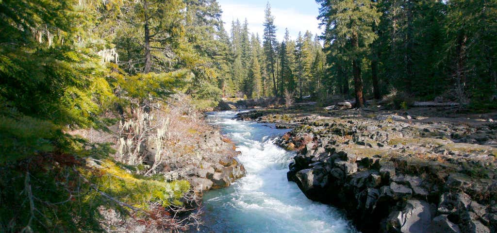
This section of the Upper Rogue River Trail parallels a quiet stretch of river and ends at a small diversion reservoir one mile south of the Forest Boundary. This reservoir joins with waters from the South Fork of the Rogue and are diverted through two wooden penstocks (pipes) to a hydroelectric power plant. The trail begins at River Bridge Campground, located one mile west of Hwy. 62 on Forest Road #6210, and heads downriver along the east bank. The trail crosses a brushy, sandy beach piled with driftwood and enters a stand of tall sugar pine, which has carpeted the forest floor with its needles and cones. Occasional views of the river occur where the trail nears the edge of 20-foot bluffs bordering the river channel. The last four miles of trail leave the river and wind through a stand of younger trees. The backwaters of the reservoir are visible as the trail returns to the riverbank. It then joins and follows an old road to the picnic area at the edge of the reservoir. A half mile access road connects to Hwy. 62 from the dam, marking the end of the Upper Rogue River Trail. Directions from Prospect: Travel north on Highway 62 to the River Bridge Campground where the trail begins.
Reviews of River Bridge Campground
2 people have reviewed this location
Ratings Summary

This section of the Upper Rogue River Trail parallels a quiet stretch of river and ends at a small diversion reservoir one mile south of the Forest Boundary. This reservoir joins with waters from the South Fork of the Rogue and are diverted through two wooden penstocks (pipes) to a hydroelectric power plant. The trail begins at River Bridge Campground, located one mile west of Hwy. 62 on Forest Road #6210, and heads downriver along the east bank. The trail crosses a brushy, sandy beach piled with driftwood and enters a stand of tall sugar pine, which has carpeted the forest floor with its needles and cones. Occasional views of the river occur where the trail nears the edge of 20-foot bluffs bordering the river channel. The last four miles of trail leave the river and wind through a stand of younger trees. The backwaters of the reservoir are visible as the trail returns to the riverbank. It then joins and follows an old road to the picnic area at the edge of the reservoir. A half mile access road connects to Hwy. 62 from the dam, marking the end of the Upper Rogue River Trail.
Be the first to add a review to the River Bridge Campground.
/-122.493,42.822,14/300x172@2x?access_token=pk.eyJ1Ijoicm9hZHRyaXBwZXJzIiwiYSI6ImNsdjQ5N2VtZDA2bW8ycW13ZHAxeGhjbjkifQ.UIccpoAxc7g3BAuK4s9vjg)
River Bridge Campground
Hours
Problem with this listing? Let us know.
Has RV parking changed? Let us know.
-
Parking
-
Pets Allowed
-
Restrooms
-
Wifi
-
Wheelchair Accessible
-
Credit Cards Accepted
- Affiliation
- National forest
- Lowest Nightly Rate
- 15.0
- Season End
- September
- Season Start
- March
- Sites Count
- 11
-
Fifty Amp
-
Full Hookup
-
Pull Through
-
Dump Station
-
Big Rigs
-
Open Seasonally
-
Age Restricted
-
Boondock
-
Cabin Sites
-
Dispersed Sites
-
Firewood
-
Fulltime Residents
-
Group Tent Sites
-
Laundry
-
Mobile Homes
-
Permit Required
-
Propane
-
Public Water
-
Pull Through RV Sites
-
Reservations
-
Sewer Hookup
-
Showers
-
Sites
-
Water Hookup
Campground
Nearby Hotels
Related Trip Guides
- Trip Guide
A road trip to filming locations featured in 'The Goonies'
- 6 Places
- 00:57
- 28 mi
- Trip Guide
The Ultimate Guide to Crater Lake National Park
- 15 Places
- Trip Guide
- Weekend
Pacific Coast Highway: Oregon - Washington
- 30 Places
- 17:36
- 670 mi
- Trip Guide
The top things to do on a U.S. Route 20 road trip
- 23 Places
- 60:25
- 3,576 mi