


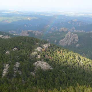
Beautiful panoramic view of Custer State Park! One of the only fire towers that is easy to get to by car (no hiking involved). The road to the fire tower is narrow and winding. Not suitable for large vehicles, Buses, or RV's.
Our trip (& pictures): https://nuttyhiker.com/mount-coolidge-fire-tower-lookout/
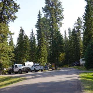
Beautiful hike. If going during the summertime expect the trail and peak to be extremely crowded! I would suggest starting early in the morning (we started at 7am and it was still crowded). Make sure to bring plenty of water and a snack/lunch to enjoy at the top!
Video of my hike: https://nuttyhiker.com/hiking-black-elk-peak/
Absolutely beautiful lake and area! Besides swimming, make sure to check out all the hiking trails, even if you just do the trail around the lake. And look for the rock that was used in National Treasure 2!
https://nuttyhiker.com/national-treasure-2-rock/
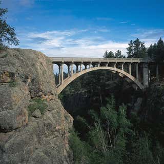
If you love old bridges, you will love this one! Couldn't figure out how to get closer to it from the pull off overlook though.
Drive slow or you will miss the pull off! We had to turn around and try again!
Our Trip: https://nuttyhiker.com/beaver-creek-bridge/
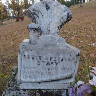
Very old cemetery but very well kept. Has an amazing view of Mount Rushmore near the flagpole. Was really cool to walk around and see all the old graves.
Took a lot of pictures and video, never caught any ghosts though =)
Definitely worth the visit if you like old cemeteries and to check out the view of Mount Rushmore!
Our Trip: https://nuttyhiker.com/mountain-view-cemetery/
I am not giving this a rating right now as we were unable to pay the entrance fee (which we would have gladly done)! They only accept cash (something we were unaware of). And since it was out in the boonies, it didn't make sense to go get cash and then come back out as we still had a ton of sites to see that day.
SO....BRING CASH WITH YOU if you plan to take a tour because they do not accept credit cards =)
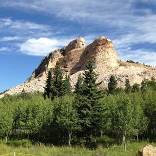
It was really neat to see a monument being carved. We had no issue paying the entrance fee (we chose to pay even though we are military), we also made sure to make a donation, shop at the gift shop, and eat at the restaurant. The only thing we didn't get to do was take the bus to the top (got there too late).
This is a privately funded monument and it is amazing to see the work that is being done.
Also, if you decide to eat in the restaurant, the service is VERY slow. Hopefully, it was a fluke but just be prepared in case it wasn't!
Don't forget to check out the museum either!
Here are photos from our visit: https://nuttyhiker.com/crazy-horse-memorial/
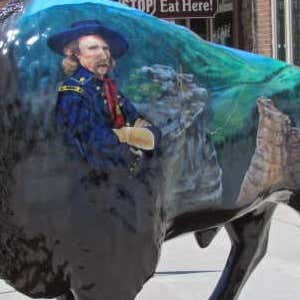
If you love artwork (and even if you don't) the painted buffalo that line Main Street in Custer are pretty dang cool and make for great photo ops! The detail on them are pretty awesome! See more pictures here: https://nuttyhiker.com/big-painted-buffalos-custer/

I was surprised to see that this was not on RoadTrippers (I had to request it be added). Great place to stop and stretch your legs if you are driving through. Or if you like to take scenic drives, I’d suggest a drive out here. There is also a museum down the road. It is free to tour and it is a self-guided tour. More pics at http://nuttyhiker.com/fort-mason-texas/
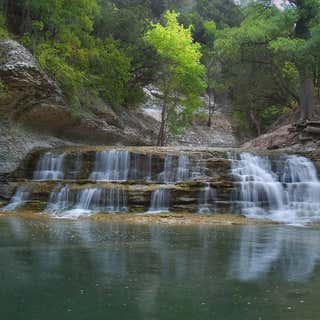
The marker on the map marks the wrong location. You can obtain a map of the main trails from the lake office which is actually where the marker on this map is.
I live on the other side of the lake, so I come here often. There are actually several falls within the park with about 5 miles of trails. There are two main trails that begin from the parking lot; one along each side of the river.
If you hike far enough, you will actually end up in a boy scouts campground as there are no boundary lines.
More pictures and info for anyone interested: http://nuttyhiker.com/chalk-ridge-falls-texas/