

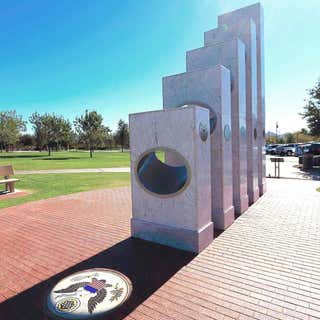
The Anthem Veterans Memorial is a monument located in Anthem, Arizona which was dedicated in 2011 to honor the sacrifice and service made by members of the United States Armed Forces.
The memorial's five white pillars represent the nation's military branches and are arranged in Department of Defense order of precedence: Army, Marine Corps, Navy, Air Force, and Coast Guard. Each pillar has an elliptical opening that slants downward toward The Great Seal of the United States. On Veterans Day – November 11 – the design allows the sun's rays to spotlight the Great Seal at 11:11 AM Mountain Standard Time. The design goal was 11:11:11 AM, but the variations each year cause the precise alignment over the next 100 years to be between 11:10:58 and 11:11:22. Due to the leap years discrepancy between the official and astronomical calendar the effect can be observed at least one day before or after Veterans Day as well.
The award-winning monument is surrounded by 1750 red paving stones engraved with the names of veterans. The red stones, the white pillars and the blue Arizona sky represent the colors in the flag of the United States.
Be aware the campground is not “big rig” friendly & can only take rigs 34-feet or less.
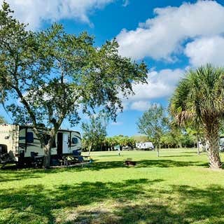
E.G. Simmons Park, located only three miles north of Ruskin, has been a popular area for outdoor enthusiasts since the mid-1960s. The Park was developed from 258 acres of native mangroves and open land areas, intertwined with waterways. An additional 200 acres of mangrove swamp has been preserved as a bird and wildlife sanctuary.
Undoubtedly, the most popular features of the park are the picnic areas and campground, which boasts beautiful waterfront views. E.G. Simmons Park has 87 individual camp sites and one group site. Bird watching in the shallow waters and surrounding mangroves are also a popular pastime of park visitors. A public beach provides visitors with a perfect setting for sunbathing and swimming, while a boat launch provides access for saltwater fishing and boating. The park also offers fishing piers and areas for bank fishing.
Features:
Barbecue Grills, Beach, Bird Watching, Boat Ramp, Camping - Group Sites, Camping - Primitive, Camping - RV, Canoe / Kayak - Launch, Canoe / Kayak - Rentals, Fishing, Pets Allowed, Picnic Shelters, Picnic Shelters, Reservable, Picnic Tables, Playground, Restrooms, Restrooms (ADA Accessible), Showers, Summer Camp
Yearly rates: $10 per night without electric; $12 per night with electricity. 1 camper vehicle per site. 8 people maximum per site.
Park hours: Winter: 8 am – 6 pm Spring 8 am – 7 pm Summer 8 am – 8 pm Fall 8 am – 7 pm
Open 362 days a year. First come – first served basis. No advanced reservations.
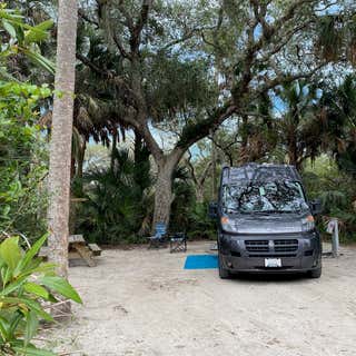
Boondocking at Bayside Campground at Escribano Point Wildlife Management Area located in the wilderness to the west of Eglin Air Force Base in the Florida Panhandle has just 12 Boondocking spots and a whole lot of wilderness.
Getting to Bayside Campground is going to require you driving off paved highways. The last 4 miles to the campground are on clay surfaces, with a few soft spots along the way, so enjoy the drive but you must stay alert. Stay on the road and do not turn off on any tracks that look iffy. Also, don’t stray into Eglin Air Force Base property either. Staying out is easy, just don’t open any fences, or cross into obviously labeled areas.
Your campsite at Bayside comes complete with a picnic table, and fire ring. Beyond that there are two port – a – potties, one of which is wheelchair accessible, and bear proof trash bins. This a boondocking location so there is no fresh water, sewer, or electricity. You have to bring in everything else with you: Fresh water for drinking, cooking and/or bathing. Be courteous with your generator and be sure to turn it off by 10pm. While I don’t recall it being posted, 10pm is the typical start for quiet hours at all campgrounds we’ve been to. Don’t be a jerk. Cell signal reception on our Verizon MiFi was fair at best, but it allowed us to get all our necessary work done.
The campground is quite literally, on the bay. Camping Spots 1 through 8 are right on the water, and 9 – 12 are just seconds farther away. For the more adventurous there are miles of hiking trails in the area as well. Kayaking, paddle boarding and canoeing are also a great option as the beach provides an easy launch platform. Blackwater Bay is huge and there are many inlets to explore that will keep you busy for hours. Fishing is also a great option as the Florida Wildlife Commission works diligently to stock and maintain native fish in the area.
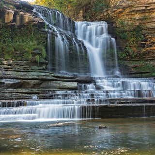
Oh my gosh! This place is awesome!! Cummins Falls State Park is an idyllic, but rugged, 211-acre day-use park on the Blackburn Fork State Scenic River. If you love to hike and you love to view waterfalls then this is a bucket list must! There is no camping in the park but there is a store, Old Mill Camp, across the street from the park entrance that has camping available. Cummins Falls is Tennessee’s eighth largest waterfall in volume of water and is 75 feet high.
The gorge area of the park is a natural feature unaltered by man, as is most of the park. While very beautiful, this is a rugged area and there are inherent hazards. The gorge and waterfall are not easily accessed and can only be reached by foot. We hiked to both the top of the falls then into the gorge to view the falls from the bottom. The trail is steep with uneven terrain and has significant elevation drops. Once in the gorge, plan to get your feet wet, depending on the amount of recent rainfall and the level of the Blackburn Fork State Scenic River. The trail surface was varied and included water crossings, boulders and other obstacles. Most of the time it was just easier to walk in the River bed but it was quite slick.
Cummins Falls’ rich history includes a time when Indians used the area to track the numerous buffalo that wallowed in the river’s shallow areas. In the 1790s, Sergeant Blackburn, a veteran of the Revolutionary War and for whom the Blackburn Fork State Scenic River was named, was awarded the land in lieu of a pension. The land was acquired by John Cummins in 1825, and he used the land to build the first of two mills. Because of his growing clientele, a larger second mill was built in 1845. Local residents would visit the mills and the falls for both commerce and recreation.
The mill was washed away during the great flood of 1928, but cars and paved highways had already begun to make the trek to Cummins Falls more accessible. The land was not rebuilt, but stayed with the Cummins family for more than 180 years until efforts by the Tennessee Parks and Greenways Foundation to purchase the land through private and public donations for resale to the state of Tennessee. The park bears the Cummins name.
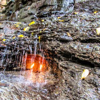
Eternal Flame Falls in Chestnut Ridge Park (Orchard Park, New York) is supposed to be a 30 ft high cascade in two segments. The top is a narrow cascade of nearly 8 ft high. The second tier spreads out more than twice the width as it cascades over shale. A small grotto to the right houses a natural gas spring that can be ignited to create a flame of 4-8 inches in height (the flame was lit when we arrived). The natural gas is a result of seepage from layers of organically-rich Hanover Shale. The gasses produced during the decomposition of the organics within the rock deposits are under pressure and push out through cracks and loose layers within the rock. One large fissure is located right within Eternal Flame Falls, in a small grotto that protects the gas seepage from the falling water and any wind, enabling it to sustain a flame when lit. Two other, smaller seepages within the grotto can be lit, although they can’t hold a flame as large or as long as the primary flame. There are several other gas seepages, or springs, around the falls, but locating them can be tricky and lighting them often impossible. Some are located underneath the pool below the falls, and can be seen as bubbles rising up from the bedrock below.
The path leading down to Shale Creek and Eternal Flame Falls snakes through mixed hardwood forest on a sandy glacial terrain, and passes a beautiful Hemlock grove as it winds around to the bottom. The descent can get a bit muddy and filled with obstacles, as erosion has exposed the sandy earth as well as a large quantity of exposed roots. Once at the creek, we walked upstream to get to the falls.
The best times to view the falls is early spring, or after bouts of rain lasting several days. There hadn't been any rain here since we've been in NY (more than a week) so we only got to see a trickle. The flame though is so cool as was the 1 mile round trip hike to get there while walking through the Shale Creek bed. We saw bubbles coming from the shale so tried to light it and "poof" it worked (I uploaded a pic of a trickle waterfall but 2 flames lit)!

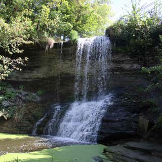
Glen Falls, in Williamsville, NY is stunning. Pioneers began building mills along the creek here as early as 1801. The village was incorporated in 1850, and named “Williamsville,” after its predominant citizen (who was then also serving as Postmaster).
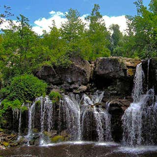
The Upper and Lower Akron Falls, in Akron Falls County Park, are formed out of irregular, cracked layers of thick limestone. The path to get to the falls was really nice but unfortunately the "falls" were down to just a trickle (wrong time of year), flowing into Murder Creek. Curiosity led me to Google Murder Creek to see where the name came from. Here is what I found.
The Legend of Murder Creek: In the early 1800s, John Dolph and his business partner built a cabin near Murder Creek with hopes of building a sawmill and starting an enterprise in this early settlement. The planning of their mill was abruptly interrupted by the desperate cries of a young native woman outside of their dwelling. They brought her inside and she told them about her family that had just been murdered by a crazy white officer named Sanders. She escaped from him just minutes before coming to the cabin. The men and their families were horror-struck at the event that had just taken place nearby. Sanders was now after the woman, intent on taking her as his bride. Sanders showed up minutes later looking for the woman, who was hiding in a nearby cave. Suspecting that the settlers were covering something, he staked out the cabin and found her when Dolph’s wife brought her food and water. When Dolph and the others were away, Sanders went to retake his prisoner. Gray Wolf, a young native warrior from a nearby camp, and the young woman’s husband-to-be, had come across the carnage at the native family’s home. Hearing the cries of his loved one, he rushed to her aid. With tomahawk in hand he fought a gruesome battle with the sword-wielding Sanders at the edge of the creek gorge. Bloody and battered, Sanders fell dead. Before Gray Wolf could be reunited with the woman, he too succumbed to his wounds. [This legend is told as the source of the name Murder Creek. Many variations of this legend exist. Some say that Gray Wolf lives, some say that the woman dies. In some cases the deaths occur via fall into the creek gorge. We couldn’t verify anything here as fact.]
A beautiful 50 foot drop that freefalls in a wide ribbon for little more than half its length and then tumbles the rest of the way down steep shale into Wolcott Creek. This was the site of Melvin's Mills Falls.
As history tells it circa 1807, Jonathan Melvin journeyed to the area known today as Wolcott. He came to inspect the falls. He liked and purchased land at a reduced rate, on the condition that he build a sawmill and a gristmill. The sawmill was placed on the north side of the falls and the grist mill on the south side. The area became known as Melvin's Mill. Not only did the mill make flour, but also chicken and cattle feed. In 1969 children set the mill on fire. There is a bit of the foundation and part of the flume still visible. We were unable to find any information or pictures of the sawmill.