“hike across the Sierra Nevadas”
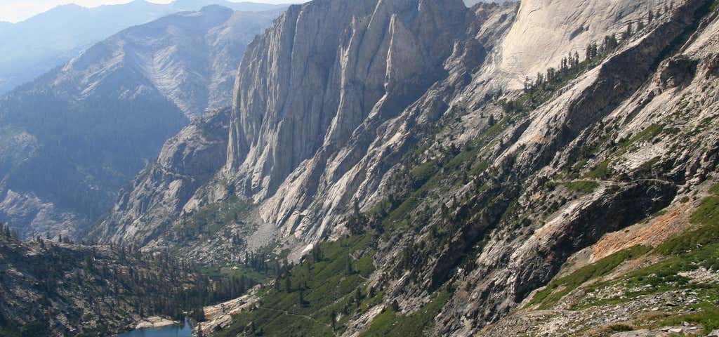
The High Sierra Trail is a hiking trail in Sequoia National Park, California. The trail crosses the Sierra Nevada from west to east. From the plateau of the Giant Forest at Crescent Meadow {elevation 6,700 ft or 2,000 m) the trail travels high on the northern wall of the canyon of the Middle Fork of the Kaweah River to Bearpaw Meadow. This first 11.4 miles (18.3 km) of the trail is a popular though strenuous two day round trip hike. The "Bearpaw High Sierra Camp" (a simple tent hotel) located here dates back to 1934. Leaving the meadow the trail climbs through the Hamilton Lakes Basin to Kaweah Gap which at 10,700 feet (3,300 m) it is one of the lowest passes over the Great Western Divide within the park. From this pass the route descends into Big Arroyo and then climbs to the Chagoopa Plateau only to drop again to 6,700 feet (2,000 m) in the Kern River Canyon. After following along the Kern River it turns east and climbs parallel to Wallace Creek to the junction with the John Muir Trail and Pacific Crest Trail 48.9 miles (78.7 km) from the Crescent Meadow. This is the end of the High Sierra Trail. Hikers may continue on the John Muir Trail 12.6 miles (20.3 km) to the summit of Mount Whitney. The Mount Whitney Trail branches to the east from the John Muir Trail 2.4 miles (3.9 km) south of Mount Whitney's summit and descends to Whitney Portal located at the end of the road from Lone Pine, California. From Crescent Meadow to Whitney Portal the trail is 72.2 miles (116.2 km) long and often takes 6 days or more for the average hiker to complete. It is occasionally performed in even less time by experts. Work began on the High Sierra Trail in 1928 and it was the first Sierra trail built solely for recreational use. Users should check with park rangers before planning a trip with riding or pack stock. At least one section of the trail is closed to stock and grazing is limited in many areas.
Reviews

It takes about a week to hike across the entire length of the High Sierra Trail. This doesn't include shuttle time. Most of the time you'll be above 10,000 feet, and there are plenty of steep climbs and steep descents. So plan accordingly.
It's an amazing hike, but definitely not for the inexperienced hiker. Also, keep in mind that for much of the year snow will cover the trail. It's only really clear from the middle of July through September.
Be the first to add a review to the High Sierra Trail.
/-118.748,36.5528,14/300x172@2x?access_token=pk.eyJ1Ijoicm9hZHRyaXBwZXJzIiwiYSI6ImNsdjQ5N2VtZDA2bW8ycW13ZHAxeGhjbjkifQ.UIccpoAxc7g3BAuK4s9vjg)
High Sierra Trail
Hours
Problem with this listing? Let us know.
Has RV parking changed? Let us know.
-
Parking
-
Pets Allowed
-
Restrooms
-
Wifi
-
Wheelchair Accessible
-
Credit Cards Accepted
Nearby Hotels
Related Trip Guides
- Trip Guide
Here's why you'll fall in love with Sequoia National Park
- 16 Places
- Trip Guide
Pay Tribute and Reflect at These US Monuments and Memorials
- 14 Places
- Trip Guide
The Ultimate Guide To Joshua Tree National Park
- 53 Places
- 11:44
- 408 mi
- Trip Guide
The top things to do on an I-40 road trip
- 35 Places
- 49:44
- 2,851 mi