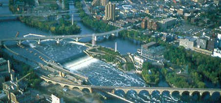
Saint Anthony Falls or the Falls of Saint Anthony, located northeast of downtown Minneapolis, Minnesota, was the only natural major waterfall on the Upper Mississippi River. The natural falls were replaced by a concrete overflow spillway (also called an "apron") after it partially collapsed in 1869. Later, in the 1950s and 1960s, a series of locks and dams was constructed to extend navigation to points upstream. Named after the Catholic saint Anthony of Padua, the falls is the birthplace of the former city of St. Anthony and to Minneapolis when the two cities joined in 1872 to fully use its economic power for milling operations. From 1880 to about 1930, Minneapolis was the "Flour Milling Capital of the World". Today, the falls are defined by the locks and dams of the Upper Saint Anthony Falls, just downstream of the 3rd Avenue Bridge, and the Lower Saint Anthony Falls, just upstream of the I-35W Saint Anthony Falls Bridge. These locks were built as part of the Upper Mississippi River 9-Foot Navigation Project. The area around the falls is designated the St. Anthony Falls Historic District and features a 1.8-mile self-guided walking trail with signs explaining the area's past.
Be the first to add a review to the St. Anthony Falls Historic District.
/-93.25861111111111,44.98166666666667,14/300x172@2x?access_token=pk.eyJ1Ijoicm9hZHRyaXBwZXJzIiwiYSI6ImNsdjQ5N2VtZDA2bW8ycW13ZHAxeGhjbjkifQ.UIccpoAxc7g3BAuK4s9vjg)
St. Anthony Falls Historic District
Hours
Problem with this listing? Let us know.
Has RV parking changed? Let us know.
-
Parking
-
Pets Allowed
-
Restrooms
-
Wifi
-
Wheelchair Accessible
-
Credit Cards Accepted
Nearby Hotels
Related Trip Guides
- Trip Guide
The Great Northern is a 3,600 mile, cross-country odyssey
- 57 Places
- 69:15
- 3,565 mi
- Trip Guide
- 1 Week
A road trip along the Great River Road
- 35 Places
- 37:29
- 1,907 mi