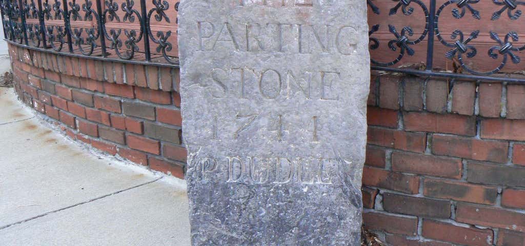
The 1767 Milestones are historic milestones located along the route of the Upper Boston Post Road between the cities of Boston and Springfield in Massachusetts. The 40 surviving milestones were added to the National Register of Historic Places in 1971. Massachusetts has a total of 129 surviving milestones including those along the upper Post Road. The first stone was erected by Paul Dudley, one of the prominent citizens of early 18th century Massachusetts, in Roxbury, which was at the time a separate community. Roxbury was located at the end of the Boston Neck, a narrow isthmus separating the mainland from the Shawmut Peninsula, where Boston was located. Travelers going by land from Boston to other areas had to travel over the neck and through Roxbury to reach their destinations. The Roxbury junction where Dudley placed the first stone was where several routes branched, heading south and west across New England. Dudley erected several stones along the road from Boston to Cambridge which wound its way from Beacon Hill along what is now Washington Street through the Dudley Square area to what is now Huntington Avenue, then along Harvard Street through Brookline Village, Coolidge Corner, and Allston crossing into Cambridge at the Great Bridge, where modern JFK Street in Cambridge becomes North Harvard Street in Allston. The stones that Dudley erected have the initial PD on them, usually at the bottom of the stone. The most chatty of these milestones (not part of this collection), is inscribed P Dudley rather than PD, and is located on the corner of Centre and South Streets in Jamaica Plain. The stones listed for miles 23 through 29 in Wayland and Sudbury are actually guideposts rather than milestones. They do not list any mileage. They were erected at road intersections rather than at the mile marks. The stones are quarried granite posts with plug & feather tool marks and post-date 1800. Miles to Boston Year Placed Image Location Town Notes 01 1741 Centre and Roxbury Streets Boston, Roxbury This stone is called the "Parting Ways" Stone. 03 1729 Centre Street, Fort Hill, Roxbury Boston, Roxbury, Fort Hill This stone is set in relief along a large stone retaining wall along Centre Street, most likely relocated to this location. 04 1729 841 Huntington Avenue Boston, Mission Hill 05 1729 210 Harvard St. Brookline 06 1729 142 Harvard Ave. Boston, Brighton 07 1729 240 N. Harvard St. Boston, Brighton 08 1734 Old Burial Ground (Mass. Ave. and Garden St.) Cambridge 23 River Road and Water Row Wayland 24 Route 20 and Landham Road Sudbury 25 Route 20 and Concord Road Sudbury 26 Route 20 and Nobscot Road Sudbury 27 listed at Boston Post Road and Dudley Road Sudbury Listed as missing in 2009 state survey. 28 Route 20 and Peakham Road Sudbury 29 Wayside Inn Road and Dutton Road Sudbury 33 143 E. Main St. Northborough 35 Boston Post Road and Dean Park Shrewsbury 43 West Main St. near I-290 Shrewsbury 47 Lincoln St. Worcester 48 Originally at 139 Salisbury St. Worcester Moved to 30 Elm Street (Worcester Historical Museum) c. 2007 It was reported to be in storage there in January 2014. 53 Route 9 at Collier's Corner Leicester 54 Originally at Main St. east of Paxton St. Leicester Stolen and recovered in the 1990s; relocated to museum space in local library in 1996. An unmarked replica is embedded in a stone wall just west of Paxton on the south side of Main Street. 56 Between 1676 and 1710 Main St. (Route 9) Leicester Opposite Leicester Drive-In. 57 500 Main St. (Route 9) Leicester In front of the Spencer Country Inn. 58 325 Main St. (Route 9) Spencer 59 Route 9, Spencer Shopper's Village Spencer 60 Route 9 at Dewey St. Spencer 61 133 West Main St. (Route 9) Spencer 62 west of 324 East Main St. (Route 9) East Brookfield Stone has been reengraved with loss of integrity. 63 184 North Brookfield Rd. East Brookfield 64 Elm Hill Rd., near North Brookfield line Brookfield 65 Elm Hill Rd., east of North Brookfield Rd. Brookfield 66 East of 31 West Main St. (Route 9) Brookfield 67 102 Foster Hill Rd. West Brookfield 68 East end of town common West Brookfield 69 147 West Main St. (Route 9) West Brookfield 70 Route 67 near Old Patrick Rd. Warren 71 Burbank and Washington Sts. (behind/north side of 129 Washington St.) Warren 72 Bemis and Washington Rds. Warren Now in front of Warren Congregational Church; relocated after 1970. 73 North side of Baypath Rd. Warren 74 970 Read St., east of West Warren Rd. Warren 99 State Rd. (Route 20) at Springfield Armory Springfield Now in storage at the Armory Museum. Source unless otherwise cited: NRHP nomination papers
Reviews
Be the first to add a review to the 1767 Milestones.
/-71.09138888888889,42.330000000000005,14/300x172@2x?access_token=pk.eyJ1Ijoicm9hZHRyaXBwZXJzIiwiYSI6ImNsdjQ5N2VtZDA2bW8ycW13ZHAxeGhjbjkifQ.UIccpoAxc7g3BAuK4s9vjg)
1767 Milestones
Hours
Problem with this listing? Let us know.
Has RV parking changed? Let us know.
-
Parking
-
Pets Allowed
-
Restrooms
-
Wifi
-
Wheelchair Accessible
-
Credit Cards Accepted
Nearby Hotels
Related Trip Guides
- Trip Guide
Visit the spooky real-life locations from 'Hocus Pocus'
- 5 Places
- 00:22
- 6 mi
- Trip Guide
Salem, Massachusetts, embraces its sordid past as Witch City
- 12 Places
- Trip Guide
The top things to do on an I-95 road trip
- 50 Places
- 41:46
- 1,983 mi
- Trip Guide
The top things to do on a U.S. Route 20 road trip
- 23 Places
- 60:25
- 3,576 mi