“the highest natural point in Indiana”
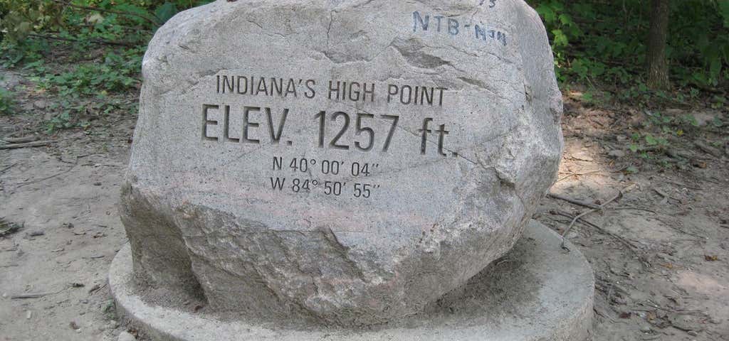
Hoosier Hill is the highest natural point in the state of Indiana at 1,257 feet (383 m) above sea level. It is in the rural area of Franklin Township, Wayne County to the northwest of Bethel. The nearest intersection to the high point is Elliot Road and County Line Road. The nearest major landmark is Interstate 70 and Richmond 11 miles (17.5 km) to the south. The Hill sits on private property; the high point sits in a forested area surrounded by farmland. In 2005, an Eagle Scout candidate named Kyle Cummings (Troop 820 from Lakeside Park, Kentucky), in cooperation with the property owner, built a trail, sign and picnic area at the high point.
Be the first to add a review to the Hoosier Hill.
/-84.848726,39.9791083,14/300x172@2x?access_token=pk.eyJ1Ijoicm9hZHRyaXBwZXJzIiwiYSI6ImNsdjQ5N2VtZDA2bW8ycW13ZHAxeGhjbjkifQ.UIccpoAxc7g3BAuK4s9vjg)
Hoosier Hill
Hours
Problem with this listing? Let us know.
Has RV parking changed? Let us know.
-
Parking
-
Pets Allowed
-
Restrooms
-
Wifi
-
Wheelchair Accessible
-
Credit Cards Accepted
Parking
Nearby Hotels
Related Trip Guides
- Trip Guide
The top things to do on a U.S. Route 20 road trip
- 23 Places
- 60:25
- 3,576 mi
- Trip Guide
The top things to do on an I-75 road trip
- 34 Places
- 31:05
- 1,933 mi
- Trip Guide
The top things to do on an I-80 road trip
- 35 Places
- 53:41
- 3,194 mi
- Trip Guide
The Ultimate Guide to Cuyahoga Valley National Park
- 14 Places