The Wabash Trace Nature Trail is a converted railroad right-of-way running over 60 miles through the scenic Southwest Iowa countryside from Council Bluffs to Blanchard on the Iowa/Missouri border.

The Wabash Trace Nature Trail is a 63-mile route, converted from a railroad right-of-way, coursing across the scenic southwest Iowa countryside from Council Bluffs to Blanchard at the Iowa–Missouri border.
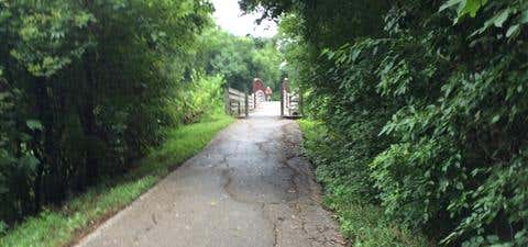
The Wabash Trace's surface is primarily crushed limestone, with sections of pavement in the towns of Shenandoah, Malvern and Silver City. Although trail advocates get some help from government agencies, the pathway is still primarily a volunteer-run trail, which accounts for the $1 fee charged for a day pass (a year-long pass costs $10—and is well worth it!).
Every Thursday night, trail users in the Council Bluffs and Mineola areas are invited to join the "Taco Ride," a social outing for supper and good times. For those with horses, an equestrian trail parallels the main Wabash Trace Nature Trail for 9.6 miles from Council Bluffs to Mineola.
Length: 63 miles
Trail end points: Iowa West Foundation Trailhead Park at E. South Omaha Bridge Rd. (Council Bluffs) to Iowa/Missouri state line (Blanchard)
Trail surfaces: Asphalt, Concrete, Crushed Stone
Info: http://www.traillink.com/trail/wabash-trace-nature-trail.aspx
Be the first to add a review to the Wabash Trace Nature Trail.
/-95.8172935295534,41.2188521844903,14/300x172@2x?access_token=pk.eyJ1Ijoicm9hZHRyaXBwZXJzIiwiYSI6ImNsdjQ5N2VtZDA2bW8ycW13ZHAxeGhjbjkifQ.UIccpoAxc7g3BAuK4s9vjg)
Wabash Trace Nature Trail
Hours
Problem with this listing? Let us know.
Has RV parking changed? Let us know.
-
Parking
-
Pets Allowed
-
Restrooms
-
Wifi
-
Wheelchair Accessible
-
Credit Cards Accepted
Nearby Hotels
Related Trip Guides
- Trip Guide
- 1 Week
Road Trip Down US 83: The Road to Nowhere
- 36 Places
- 34:43
- 1,869 mi
- Trip Guide
- 1 Week
A road trip along the Great River Road
- 35 Places
- 37:29
- 1,907 mi
- Trip Guide
The top things to do on a U.S. Route 20 road trip
- 23 Places
- 60:25
- 3,576 mi
- Trip Guide
The top things to do on an I-80 road trip
- 35 Places
- 53:41
- 3,194 mi