“awesome cycling trail”
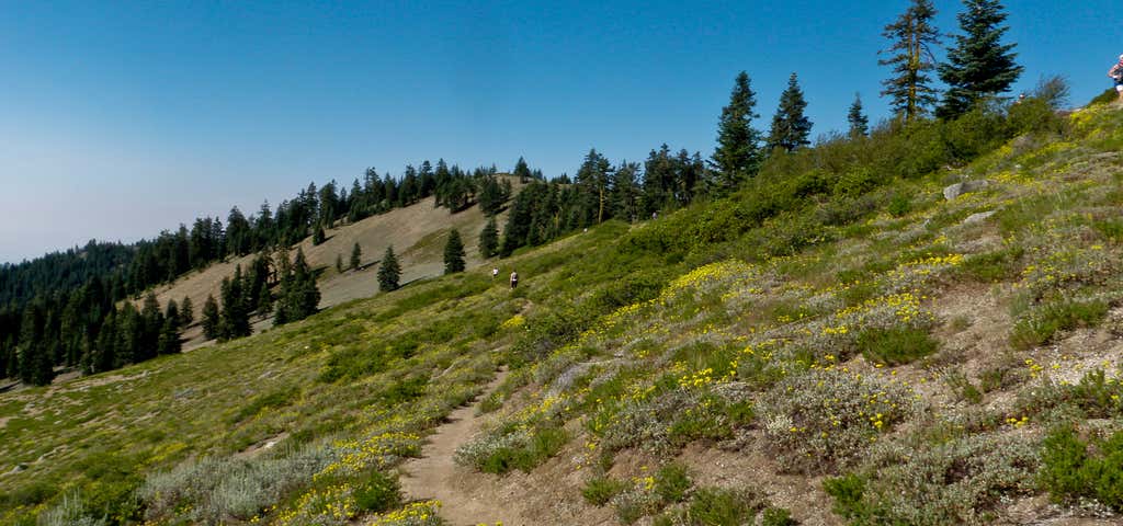
The Siskiyou Crest Mountain Bike Route begins at the Mt. Ashland Ski Area parking lot (elevation 6,600 feet) and follows Forest Service road 20 for 14 miles along the crest of the Siskiyou Mountains to Jackson Gap. From the Gap road 800 ascends on the right about 1.5 miles to the summit of Dutchman Peak (elevation 7,418 feet). Total distance from Mt. Ashland parking lot to Dutchman Peak and back is about 31 miles. Road 20 is a decomposed granite surface that is maintained each year, but may be rutted or contain rock fall in places. Road 800 to Dutchman Peak is more primitive, and requires some technical ability. Attractions and Considerations: Part of this ride is on the route of the famous "Revenge of the Siskiyous" Mountain Bike Race, but don't be alarmed, the race doesn't derive it's reputation from this section. The route winds along the crest of the Siskiyou Mountains. The sub-alpine scenery is terrific, and you can tailor the ride to your fitness level or schedule by turning around at any point. Carry sufficient water and a lunch or snack. There is a picnic area and Mt. Ashland Campground about 0.5 mile from the ski area parking lot. Another 0.5 mile further out is road 300 to the right which will take you on a side trip to the summit of Mt. Ashland (elevation 7,533 feet). Back on road 20 again at about the 2.0 mile point, a short road to the left leads to Grouse Gap Shelter, a nice place for a picnic with a view of Mt. Shasta. About 11 miles out is Wrangle Gap; here road 2030 goes downhill to the right about 0.5 mile to Wrangle Camp, a good lunch spot with picnic tables, shelter, water (June-September), and a vault toilet. At the top of Dutchman Peak is one of the very few "cupola style" fire lookouts left in the Pacific Northwest. The lookout was built in 1927. A free brochure entitled The Siskiyou Loop is available at the Ranger Station. Designed as an auto tour guide, bikers will also find it useful and very interesting. Please note that the Pacific Crest National Scenic Trail, which parallels Forest Service road 20 most of the route, is closed to bicycles. Bicycles are not allowed on the ski slopes at Mt. Ashland. Directions from Ashland: Travel south on I-5 for 9 miles to the Mt. Ashland exit (exit 5). Follow the sign to the Mt. Ashland Access Road (0.7 miles). Turn right onto the Mt. Ashland Road (County Road 1151) and continue 9 miles to the Ski Ashland Parking Lot.

The Siskiyou Crest Mountain Bike Route begins at the Mt. Ashland Ski Area parking lot (elev. 6600') and follows Forest Road 20 for 14 miles along the crest of the Siskiyou Mountains to Jackson Gap. From the Gap, Road 800 ascends on the right about 1.5 miles to the summit of Dutchman Peak (7,418 feet). Total distance from Mt. Ashland parking lot to Dutchman Peak and back is about 31 miles. Road 20 is a decomposed granite surface that is maintained each year, but may be rutted or contain rockfall in places. Road 800 to Dutchman Peak is more primitive, and requires some technical ability. Part of this ride is on the route of the famous "Revenge of the Siskiyou" Mountain Bike race, but don't be alarmed, the race doesn't derive it's reputation from this section. The route winds along the crest of the Siskiyou Mountains. The subalpine scenery is terrific, and one can tailor the ride to your fitness level or schedule by turning around at any point. Carry sufficient water and a lunch or snack. There is a picnic area and campground about a half mile from the ski area parking lot. Another 1/2 mile farther out is Road 300 to the right which will take you on a side trip to the summit of Mt. Ashland (7533'). Back on road 20 again at about the two mile point, a short road to the left leads to Grouse Gap Shelter, a nice place for a picnic with a view of Mt. Shasta. About 11 miles out is Wrangle Gap; here road 2030 goes downhill to the right about half a mile to Wrangle Camp, a good lunch spot with picnic tables, shelter, water (June-Sept), and a vault toilet. At the top of Dutchman Peak is one of the very few "cupola style" fire lookouts left in the Pacific Northwest. The lookout was built in 1927, and a free brochure entitled The Siskiyou Loop is available at the Ranger Station. Designed as an auto tour guide, bikers will also find it useful and very interesting. Please note that the Pacific Crest Trail, which parallels Forest Road 20 most of the route, is closed to bicycles. Bicycles are also not allowed on the ski slopes at Mt. Ashland.
Be the first to add a review to the Siskiyou Crest Mountain Bike Route.
/-122.7133557,42.0755859,14/300x172@2x?access_token=pk.eyJ1Ijoicm9hZHRyaXBwZXJzIiwiYSI6ImNsdjQ5N2VtZDA2bW8ycW13ZHAxeGhjbjkifQ.UIccpoAxc7g3BAuK4s9vjg)
Siskiyou Crest Mountain Bike Route
Hours
Problem with this listing? Let us know.
Has RV parking changed? Let us know.
-
Parking
-
Pets Allowed
-
Restrooms
-
Wifi
-
Wheelchair Accessible
-
Credit Cards Accepted
Nearby Hotels
Related Trip Guides
- Trip Guide
A road trip to filming locations featured in 'The Goonies'
- 6 Places
- 00:57
- 28 mi
- Trip Guide
Pay Tribute and Reflect at These US Monuments and Memorials
- 14 Places
- Trip Guide
The Ultimate Guide To Joshua Tree National Park
- 53 Places
- 11:44
- 408 mi
- Trip Guide
The top things to do on an I-40 road trip
- 35 Places
- 49:44
- 2,851 mi