
Fall Viewing Spots trip with Anne in September 2023.
266 Shoreham Village Drive, Fairfield, Connecticut, United States
Date:

Date:
https://oremsdiner.com/
Menu: https://oremsdiner.com/static/media/OremsLimitedMenu12-21.5ddcc7ac2e3a0c71469a.pdf
Date:
Driving directions: From the South: take Route 8 north, Exit 42, (Harwinton Exit). Proceed west on Route 118 to the center of Litchfield, and then go north on Route 63 to the rotary in Goshen Center. Take Route 4 west from Goshen approximately 4 miles to the entrance on the left for Mohawk State Forest.
https://portal.ct.gov/DEEP/State-Parks/Forests/Mohawk-Mountain-State-Forest-State-Park
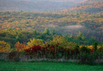
Mohawk Summit: Mohawk Mountain (elev. 1683 feet) is the highest point on the blue-blazed Mattatuck Trail. The summit offers views of the Taconic Mountains and Berkshire Mountains to north and northwest including Bear Mountain, Canaan Mountain, and Cream Hill in Connecticut as well as peaks in Massachusetts (Race Mountain, Mount Everett, Mount Greylock) and the eastern Catskills in New York State. [Opens 8:00 AM]
Map: https://portal.ct.gov/-/media/DEEP/stateparks/maps/mohawknsummer2021.pdf
I assume Mohawk Summit is at the viewpoint Mohawk Tower (on southside)
Date:
Driving directions: From the North – Great Barrington or Pittsfield, MA: travel south on Route 7 into Canaan and take a left heading east on Route 44, then take a right onto Route 272 south. The park will be on the left.
https://portal.ct.gov/DEEP/State-Parks/Parks/Dennis-Hill-State-Park
The park is a "walk-in" facility with limited parking available at the entrance. No parking fee.
Map: https://portal.ct.gov/-/media/DEEP/stateparks/maps/dennishillpdf.pdf

Colebrook (drive through)
Date:

Date:
Driving directions: Off Route 44: take Route 318 in Barkhamsted. Go across the steel bridge and take an immediate left onto East River Road. The recreation area is approximately 1 mile up on the left.
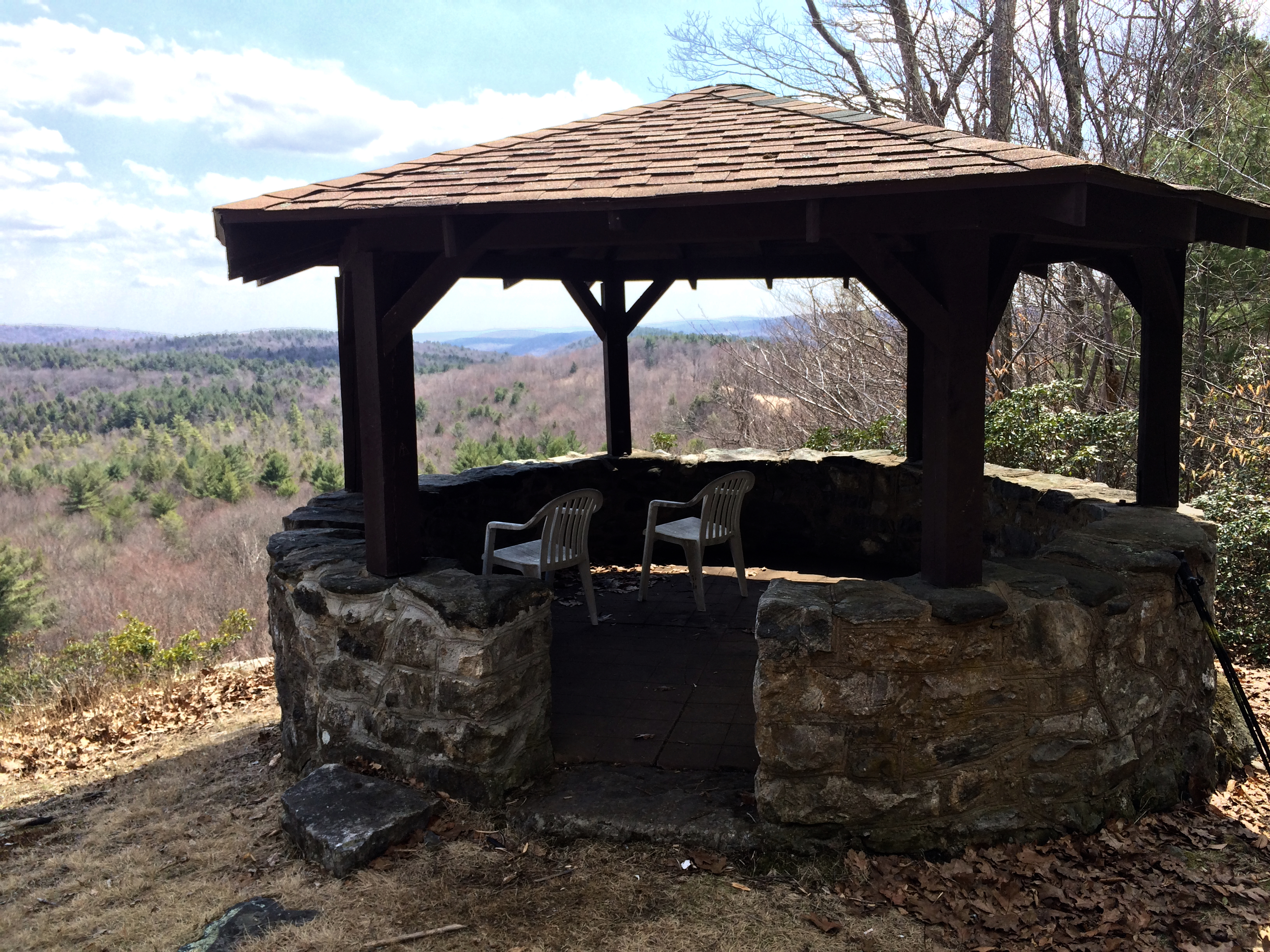
Jessie Gerard Trail (Yellow): Starts at East River Road (which is south entrance) near the old Indian Settlement known as Barkhamsted Lighthouse. The right trail fork goes through the lighthouse site and continues northerly to the Chaugham Lookouts (I couldn't find on map). The left trail fork climbs more directly to the overlooks by 299 stone steps. The views from this area are some of the best in the state. Continuing north, the trail passes between the Veeder Boulders to the picnic area on Greenwoods Road. Distance - 1.3 miles.
(The viewing points appear to be mid-right).
Map: https://portal.ct.gov/-/media/DEEP/stateparks/maps/Peoplespdf.pdf

Date:
https://www.hotels.com/trips/egti-590-E5E-846B/details/NDhjZWQ3M2MtMTQ3YS01MjI1LTlhNDctMWNmYmM5ZjQ2NmIxOzhkNDZkYzM3LThhNmQtNDc0OC05M2JhLTdjZDM5MWI5NDYzMV8w
2 x Single Rooms with Queen beds. Hotel has 2 restaurants and bar/lounge; outdoor pool; sauna; garden; free wifi.
Date:
Parking is located on Summit Ridge Drive, Simsbury, CT 06070. (for GPS)
The Tower Trail is 1.25 miles long; a walk to the Tower takes approximately 30 - 40 minutes.
https://portal.ct.gov/DEEP/State-Parks/Parks/Talcott-Mountain-State-Park
Date:
A left onto Route 219 to Route 318 offers Instagram-ready views of Saville Dam, with its stone gatehouse and backdrop of sugar maples, oaks, and pines.

Date:
Motor on through the American Legion State Forest before a stop at the Riverton General Store,at Hogback Dam, to enjoy coffee or sandwiches on the outdoor patio.
.JPG)
Date:
Ten miles to the west lies Norfolk, home to Haystack Mountain State Park, where you can drive halfway up and then hike to the top (the 1929 tower offers views in all directions).

Date:
Continue south on 272 to Route 4 toward Goshen, your last stop. Here, you won’t want to miss Thorncrest Farm, where the cows supply a key ingredient for Milk House Chocolates’ gourmet sweets. A box or two just might be the perfect New England road trip souvenir.

Date:
The home of the Arethusa Farm experience is settled right in the borough of Bantam, just a few miles down the road from our dairy farm. Next-door to our fine dining restaurant Arethusa al tavolo and across the street from our bakery, Arethusa a mano, this scoop shop offers fresh waffle cones and our full line of dairy products: cheese, yogurt, ice cream, milk, butter, sour cream, and our seasonal eggnog.
https://www.arethusafarm.com/bantam

Date:
Mt. Tom is one of the oldest parks in the state park system; it is named for the mountain within its boundaries. In 1915 it was established as a state park. There is a stone tower on top of the mountain that is a favored destination among hikers. The summit of Mt. Tom is 1325 feet above sea level, 125 feet higher than its Massachusetts counterpart. The tower trail is less than one mile long and rises some 500 feet.
There's a beach for swimming (after the hike).


266 Shoreham Village Drive, Fairfield, Connecticut, United States
Date:
