NH has some of the most beautiful landscapes in the whole country. Waterfalls are beautiful no matter where they are, but these waterfalls look particularly scenic!
Sabbaday Falls is one of the most popular waterfalls in New Hampshire. Its history, beauty and easy hike make it one of the most visited waterfalls in the state. The path to Sabbaday Falls is Handicapped accessible and is has informational postings along the trail. Sabbaday Falls has a 45' drop. A gravel pathway and wooden steps leads you to the edges of the falls. The handicapped accessible trail takes you to the top where the "Best viewing" area is located. Swimming is not allowed at Sabbaday Falls. Picnic area and bathrooms located near parking area. The falls was said to have gotten its name from workers who were working on a road connecting Albany Intervale to Waterville. One Saturday night, these workers decided to take a rest and come back the following Spring. Since their rest day started on Sunday, which was the Sabbath Day, they renamed this brook to “Sabbaday”. It was said the workers never returned to finish the work though the name persisted.
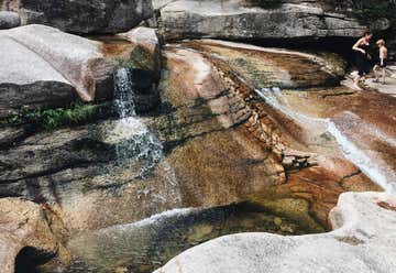
Diana’s Baths are a must see any time of the year when you are in the North Conway area and want to experience nature at its finest. Located in Bartlett, just minutes from North Conway Village, Diana’s baths lie along Lucy Brook in Bartlett which is fed from Big Attitash Mountain. During the summer the baths are a great place for children and grown-ups alike to enjoy the tranquility of nature, and explore the many rocks, ledges, cascading falls and pools in the brook. The cascading falls measure approximately 75 feet in total height. The hike to Diana’s Baths is a fairly easy 6/10ths of a mile on a relatively flat, wide gravel path. Being part of the US National Forest System, there is a large parking lot at the entrance to the hiking path and a self service pay station which requires visitors to purchase and display a daily pass on the dashboard of your vehicle. This daily pass (currently $5.00 per day) may be used at other national Forest sites as well. Dogs are allowed along the trails, but owners must clean-up after their pets. While in the area, be sure to visit Cathedral Ledge, Whitehorse Ledge, and Echo Lake State Park which are all located within a few miles of Diana’s Baths. A LITTLE HISTORY OF THE SITE In the 1860’s, after building a house and barn on the banks of the brook, George Lucy built a water wheel powered sawmill. In the 1890’s George built a 12 room boarding house for tourists to visit the site. In the 1930’s Chester Lucy built a concrete dam with a water feed and turbine system to replace the water wheel used to power the sawmill. Both the rooming house and sawmill were eventually sold to the US Government and have become part of the national Forrest land. Due to the deterioration, the buildings were eventually removed from the site in the 1960’s. Remnants of the site can still be seen today including the old cellar holes and parts of the dam system, feed tube and turbine gears used to power the sawmill.
DIRECTIONS The parking lot access for Diana’s Baths is located on West Side Road, North Conway NH 03860. From Conway Village, head north on Route 16/302 (White Mountain Hwy) past the Eastern Slope Inn. At the next set of lights turn left onto River Rd. Stay straight on River road for approximately 1 mile when the road changes to West Side Road. Continue straight on West Side road for approximately 1.5 miles (you will go past the sign for the road leading to Cathedral Ledge) and you will see the sign for Diana’s Baths parking lot on the left hand side of the road. PLEASE NOTE: This is a very popular scenic attraction, especially in the summer and fall! The parking lot fills up fast. The good news is that there usually is a number of people coming and going from the parking lot. With a little patience, it may take a few minutes to get a spot if the lot is full.
Experience this 2.8-mile out-and-back trail near Harts Location, New Hampshire. Generally considered a moderately challenging route, it takes an average of 1 h 44 min to complete. This is a very popular area for hiking and snowshoeing, so you'll likely encounter other people while exploring. Dogs are welcome, but must be on a leash. The Arethusa Falls Trail starts on Arethusa Falls Road just off Crawford Notch Road/US Route 302. Begin by hiking up Bemis Brook Trail passing a few waterfalls before joining the Arethusa Falls Trail. After soaking in the view and resting at the falls, follow the Arethusa Falls Trail back to the start point.
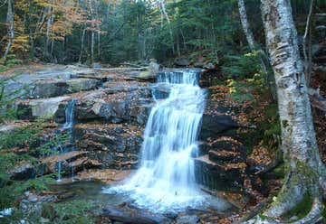
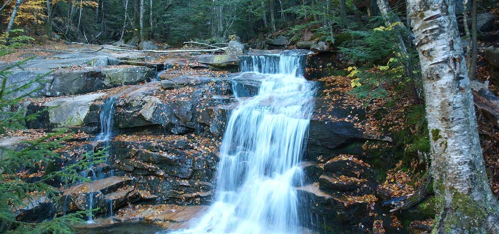
The Falling Waters Trail is a popular 3.2-mile trail to the summit of Little Haystack Mountain. Along the way are three waterfalls, each with their own personality. Stairs Falls, where Dry Brook plunges 15 feet down small granite steps into a shallow pool, is the first waterfall seen on this trip. Just 100 feet above Stairs Falls is Swiftwater Falls, a 60-foot tall mix of cascades and small plunges. The trail crosses Dry Brook in front of this waterfall, so if the crowds are thick on the day of your visit, this will be a busy spot.
The final and most impressive of the waterfalls, 80-foot Cloudland Falls, is a picturesque fan-type horsetail. The fanning structure of this waterfall is the most impressive aspect of the falls, with the width at the top of the falls at about 2 feet, and the width at the bottom about 25 feet during periods of high water.

Length 0.2 mi Elevation gain 19 ft Route type Out & back Discover this 0.2-mile out-and-back trail near Bristol, New Hampshire. Generally considered an easy route, it takes an average of 4 min to complete. This trail is great for walking, and it's unlikely you'll encounter many other people while exploring. The best times to visit this trail are April through September. There is one clear downside to the falls: the water sometimes emits an odor that some would consider to be a bit off-putting. It is unknown if the smell is from the river or not, but it can be strong enough to make you think twice about swimming in the huge, deep, and dark pool at the base of the falls.
Welton Falls Length: 2.4 miles out-and-back
Difficulty (click for info): Easy
Elevation Gain: -300 feet
Rating (click for info): 5/10
Height: 30'
River: Fowler River
Driving Directions: Parking and trailhead are at the end of Shem Valley Road in Alexandria, NH. To get there, take West Shore Road off Rt. 3A in Bristol, 2.1 miles north of Rt. 104. After 1.8 miles, bear left onto Cardigan Mountain Road. Cross the Alexandria town line in 0.5 miles, where it becomes Fowler River Road. Continue for another 0.7 miles, then turn left onto North Road. When North Road ends in 1.0 mile, turn right onto Washburn Road, and then bear right onto Mount Cardigan Road in another 0.2 miles. Drive for 3.1 miles, and turn right to stay on Mount Cardigan Road (Hutchins Hill Road continues straight). Keep going 0.5 miles and stay straight onto Shem Valley Road. The AMC Hut and a large parking area are at the end of this road (1.5 miles down).
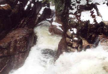
About the Hike: Welton Falls is a small waterfall, more impressive in the gorge that it flows through than in its size. Though not the shortest access, a fine brookside trek downstream to Welton Falls can be made from AMC's Cardigan Lodge. Follow the Manning Trail from the right side of the lodge, at the edge of the field. The trail first passes through a campsite area, then crosses a cross-country ski trail. It soon swings left and follows the stream from a distance for the rest of the way. In one interesting section, you can look down into a washed-out ravine to see the stream. After a mile, the trail crosses the river on small rocks. You will arrive at the top of the waterfall in 0.2 miles. As you approach the gorge, look for a side path on the left, which leads to a ledgy area just above the plummeting waters where you can look straight down on the falls. The waterfall runs through a huge gorge before falling 15 feet into a swirling pool. Continue down the trail for viewpoints of the falls from the side and from the river below.
Hidden down a little-traveled dirt road that extends from Sandwich to Waterville Valley, Beede Falls is a local fun spot. Although it is difficult to get to by road, it is a very easy walking adventure suitable for all. In addition to the main falls, the area itself is very scenic, with a few other sights to see. To start, follow the graded gravel trail downhill from the park signs. Bear left as another path to the lower falls goes right. The walkway will take you 0.1 miles to an improved area of blended rock steps and crooked wooden railings around the outlet of the pool at the base of the waterfall. The falls are very rewarding for almost no effort. They are completely unique - the Bearcamp River slides down a long sloped ledge with a small drop at the end. The water spreads out in a sheet over the rock as it rushes down. At the base of the slide is a large pool. The soil under the pool is mainly sand, and in low water, a small beach forms on one side of the water. In high water, the pool is absolutely perfect for swimming (although a bit shallow). Swimmers can even sit underneath or behind the falling water!
When you're ready to move on from the falls, continue on the Bearcamp River Trail along the sluggish waterway, then across it on a sturdy bridge. Reach a junction on the other side. Bear left for a moment to see Cow Cave; right will loop you back to the beginning. In a short distance, the trail leads beside this rocky seam in the forest floor, where a shallow crevasse opens up along a downhill slope. Return to the junction and take the other fork back, following the sign for Lower Falls. The trail follows beside the river and soon comes out to a section where the water is constrained into a ledge flume. It continues downstream to where the water is released and spreads out across wide open ledges. The trail crosses the water here, but stroll down further first to see the lower falls from the bottom, where it gracefully tumbles over steps and bumps in the rock mass. Then return to the crossing and walk over the water to the trail on the other side. This might involve getting wet, but this area was built for splashing around. The trail will take you a short distance back to the parking area. If you don't want to cross the river, it is quick and easy enough to go back the way you came.
TIPS FOR VISITING WATERFALLS & SWIMMING HOLES Here are some tips to help ensure that your trip to New England's waterfalls and swimming holes will be a safe and enjoyable one: DON'T FORGET THE ESSENTIALS - When you visit waterfalls, you should consider bringing all of the following: (a) bug spray; (b) food/snacks; (c) water/sports drinks; (d) camera/smart-phone; (e) guidebook/trail map; (f) daypack/backpack; and (g) hiking shoes, hiking boots or watershoes. A full day hiking packing list can be found here. CONSIDER BUYING WATER SHOES - You won't see too many people using them, but watershoes are fantastic pieces of equipment that can make your trip to waterfalls and swimming holes safer and more enjoyable. Merrill and Keen make some fantastic watershoes (here are some great ones from Merrill: womens / mens). LEAVE NO TRACE - When you visit waterfalls and swimming holes, you'll often see some trash and sometimes you'll even find clothing left behind by others. It's really, really sad, and it irks the heck out of us. Won't you consider carrying out some of trash and clothing left by others when you leave? That would leave the spot more beautiful for the next person. Bring a trash bag and be a hero! PRIVATE PROPERTY - Many waterfalls and swimming holes are located on private property and so we are truly fortunate that many landowners allow us to enjoy them. If you want to ensure that they stay open to the public, please do your best to leave no trace. If you see a sign that says 'Private Property', turn around and find another waterfall to visit or a different place to swim. BRING A DSLR CAMERA AND TRIPOD WITH YOU - If you want to take high-quality photographs of waterfalls, your smart-phone just won't cut it. Get a DSLR camera, a tripod, and learn to master the art of waterfall photography. SCOUT FIRST, SWIM SECOND - Never enter a swimming hole without first scouting it, even if you see somebody else swimming in it. Stop and access the risks based upon the depth of water, the power of the current, evidence of slippery rocks, and other safety factors. CLIFF JUMPING - Cliff jumping is dangerous. Like, seriously dangerous. Understand the risks before you partake in this activity. Many have died from doing this in New England. Here is a list of all known deaths at waterfalls and swimming holes in New England. PLEASE DON'T BUILD ROCK CAIRNS - Please do not build new rock cairns at waterfalls or swimming holes. Cairns are a strong reminder of human presence, and don't we all want to see waterfalls in their natural state and glory? Photographers get particularly annoyed at seeing cairns, so please resist the urge to build them. DON'T RELY ON YOUR GPS TO GET YOU TO THE TRAILHEAD - Waterfalls don't have addresses, so relying on your GPS to get you to a trailhead is great way to get yourself lost. You need a guidebook, a road atlas, and/or a hiking map to visit the vast majority of waterfalls in New England. Also keep in mind that waterfalls are often located in wild areas, where smart-phone map apps and car GPS units may not work at all. WATERFALLS IN SPRING - The best time to visit waterfalls is generally in the spring during the annual snowmelt (which is April to June). However, most waterfalls will often look great for several days after a significant rain storm. HELP KEEP THE ULTRA-SECRET SWIMMING HOLES A SECRET (FOREVER) - If you find some ultra-secret swimming holes, please do your best to keep them a secret. Do not post their locations online or wildly share directions or photos with others. All of the swimming holes that are included in the guidebook and online through this website are the well-known swimming spots. There are many more holes that are much further off the beaten path, but they deserve a chance to stay wild and pristine. DON'T SCRAMBLE UP WATERFALLS - So many people been seriously injured and killed in the waterfalls of New England. Many of these folks got too close to a waterfall and slipped and fell. Don't become a statistic: stay far back from the edge. WEAR TRACTION IF YOU VISIT WATERFALLS IN WINTER - Visiting waterfalls in winter can be rewarding, but there is often a higher element of danger. You may need crampons, snowshoes, and/or some other form of traction (like Microspikes) in order to safely hike to waterfalls in winter. SUPPORT NON-PROFIT ORGANIZATIONS THAT CONSERVE WATERFALLS & SWIMMING HOLES - There are some organizations in New England that work diligently to conserve and maintain waterfalls and swimming holes. Please consider supporting these organizations, either with their trail maintenance projects or with monetary donations. Here are three excellent organizations engaged in this extremely important mission: the Trustees of Reservations, the Vermont River Conservancy and the Nature Conservancy.
