The Missoula floods (also known as the Spokane floods or the Bretz floods or Bretz's floods) were cataclysmic glacial lake outburst floods that swept periodically across eastern Washington and down the Columbia River Gorge at the end of the last ice age. These floods were the result of periodic sudden ruptures of the ice dam on the Clark Fork River that created Glacial Lake Missoula. After each ice dam rupture, the waters of the lake would rush down the Clark Fork and the Columbia River, flooding much of eastern Washington and the Willamette Valley in western Oregon. After the lake drained, the ice would reform, creating Glacial Lake Missoula again.

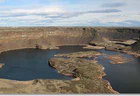
Dry Falls is a 3.5-mile-long (5.6 km) scalloped precipice with four major alcoves, in central Washington scablands. This cataract complex is on the opposite side of the Upper Grand Coulee from the Columbia River, and at the head of the Lower Grand Coulee, northern end of Lenore Canyon.[1] According to the current geological model, catastrophic flooding channeled water at 65 miles per hour (105 kph) through the Upper Grand Coulee and over this 400-foot (120 m) rock face at the end of the last glaciation. It is estimated that the falls were five times the width of Niagara Falls,[2]: 116 with ten times the flow of all the current rivers in the world combined.[3]
$75 per night
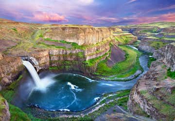
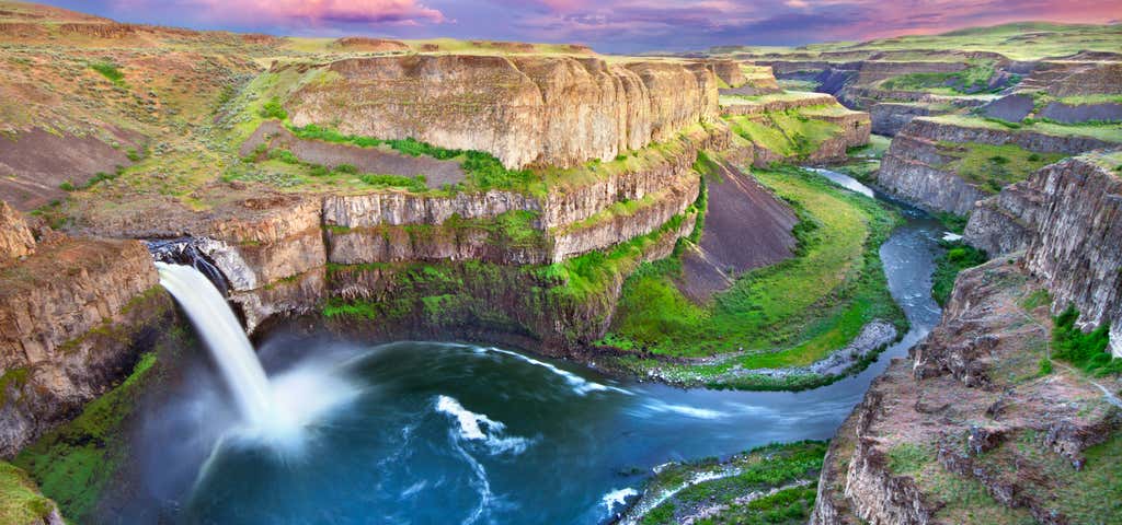
Palouse Falls is a waterfall on the Palouse River, about 4 mi (6 km) upstream of the confluence with the Snake River in southeast Washington, United States. The falls are 200 ft (61 m) in height.[2] The falls consist of an upper fall with a drop around 20 ft (6.1 m), which lies 1,000 ft (305 m) north-northwest of the main drop, and a lower fall, with a drop of 200 ft (61 m). It is in the 94-acre (38 ha) Palouse Falls State Park.
1404 North Farragut Street, Portland, Oregon, United States
Welcome home
As the water emerged from the Columbia River gorge, it backed up again at the 1 mile (1.6 km) wide narrows near Kalama, Washington. Some temporary lakes rose to an elevation of more than 400 ft (120 m), flooding the Willamette Valley to Eugene, Oregon, and beyond. Iceberg-rafted glacial erratics and erosion features are evidence of these events. Lake-bottom sediments deposited by the floods have contributed to the agricultural richness of the Willamette and Columbia Valleys. Glacial deposits overlaid with centuries of windblown sediments (loess) have scattered steep, southerly sloping dunes throughout the Columbia Valley, ideal conditions for orchard and vineyard development at higher latitudes.
After analysis and controversy, geologists now believe that there were 40 or more separate floods, although the exact source of the water is still being debated. The peak flow of the floods is estimated to be 40 to 60 cubic kilometers per hour (9.5 to 15 cubic miles per hour).[2][3] The maximum flow speed approached 36 meters/second (130 km/h or 80 mph).[2] Up to 1.9×10¹⁹ joules of potential energy were released by each flood (the equivalent of 4,500 megatons of TNT). For comparison, this is 90 times more powerful than the most powerful nuclear weapon ever detonated, the 50-megaton "Tsar Bomba". The cumulative effect of the floods was to excavate 210 cubic kilometres (50 cu mi) of loess, sediment and basalt from the Channeled Scablands of eastern Washington and to transport it downstream and out the mouth of the Columbia river..
